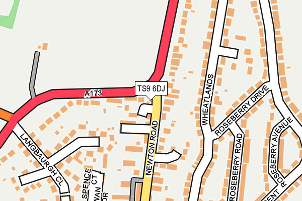
TS9 6DJ is located in the Great Ayton electoral ward, within the unitary authority of North Yorkshire and the English Parliamentary constituency of Richmond (Yorks). The Sub Integrated Care Board (ICB) Location is NHS Humber and North Yorkshire ICB - 42D and the police force is North Yorkshire. This postcode has been in use since January 1980.


GetTheData
Source: OS OpenMap – Local (Ordnance Survey)
Source: OS VectorMap District (Ordnance Survey)
Licence: Open Government Licence (requires attribution)
| Easting | 456310 |
| Northing | 511445 |
| Latitude | 54.495218 |
| Longitude | -1.132130 |
GetTheData
Source: Open Postcode Geo
Licence: Open Government Licence
| Country | England |
| Postcode District | TS9 |
| ➜ TS9 open data dashboard ➜ See where TS9 is on a map ➜ Where is Great Ayton? | |
GetTheData
Source: Land Registry Price Paid Data
Licence: Open Government Licence
Elevation or altitude of TS9 6DJ as distance above sea level:
| Metres | Feet | |
|---|---|---|
| Elevation | 100m | 328ft |
Elevation is measured from the approximate centre of the postcode, to the nearest point on an OS contour line from OS Terrain 50, which has contour spacing of ten vertical metres.
➜ How high above sea level am I? Find the elevation of your current position using your device's GPS.
GetTheData
Source: Open Postcode Elevation
Licence: Open Government Licence
| Ward | Great Ayton |
| Constituency | Richmond (Yorks) |
GetTheData
Source: ONS Postcode Database
Licence: Open Government Licence
| June 2022 | Shoplifting | On or near Bradleys Terrace | 63m |
| June 2022 | Anti-social behaviour | On or near California Grove | 119m |
| June 2022 | Criminal damage and arson | On or near Newton Road | 270m |
| ➜ Get more crime data in our Crime section | |||
GetTheData
Source: data.police.uk
Licence: Open Government Licence
| Guisborough Road | Great Ayton | 116m |
| Guisborough Road | Great Ayton | 116m |
| Stephens Garage (Newton Road) | Great Ayton | 124m |
| Stephens Garage (Newton Road) | Great Ayton | 168m |
| Roseberry Crescent (A173) | Great Ayton | 249m |
| Great Ayton Station | 1.3km |
| Nunthorpe Station | 4.4km |
| Kildale Station | 4.6km |
GetTheData
Source: NaPTAN
Licence: Open Government Licence
GetTheData
Source: ONS Postcode Database
Licence: Open Government Licence


➜ Get more ratings from the Food Standards Agency
GetTheData
Source: Food Standards Agency
Licence: FSA terms & conditions
| Last Collection | |||
|---|---|---|---|
| Location | Mon-Fri | Sat | Distance |
| Linden Grove | 17:15 | 09:00 | 531m |
| Great Ayton Post Office | 17:00 | 11:45 | 726m |
| Station Road | 16:45 | 09:00 | 889m |
GetTheData
Source: Dracos
Licence: Creative Commons Attribution-ShareAlike
| Facility | Distance |
|---|---|
| Roseberry Academy Roseberry Crescent, Great Ayton, Middlesbrough Grass Pitches | 382m |
| Christ Church Hall Guisborough Road, Great Ayton, Middlesbrough Sports Hall | 823m |
| Great Ayton Cricket & Football Club Easby Lane, Great Ayton, Middlesbrough Grass Pitches | 1km |
GetTheData
Source: Active Places
Licence: Open Government Licence
| School | Phase of Education | Distance |
|---|---|---|
| Roseberry Academy Roseberry Crescent, Great Ayton, Middlesbrough, TS9 6EP | Primary | 376m |
| Marwood Church of England Voluntary Controlled Infant School, Great Ayton Low Green, Great Ayton, Middlesbrough, TS9 6NN | Primary | 931m |
| Chandlers Ridge Academy Chandlers Ridge, Nunthorpe, Middlesbrough, TS7 0JL | Primary | 4.5km |
GetTheData
Source: Edubase
Licence: Open Government Licence
The below table lists the International Territorial Level (ITL) codes (formerly Nomenclature of Territorial Units for Statistics (NUTS) codes) and Local Administrative Units (LAU) codes for TS9 6DJ:
| ITL 1 Code | Name |
|---|---|
| TLE | Yorkshire and The Humber |
| ITL 2 Code | Name |
| TLE2 | North Yorkshire |
| ITL 3 Code | Name |
| TLE22 | North Yorkshire CC |
| LAU 1 Code | Name |
| E07000164 | Hambleton |
GetTheData
Source: ONS Postcode Directory
Licence: Open Government Licence
The below table lists the Census Output Area (OA), Lower Layer Super Output Area (LSOA), and Middle Layer Super Output Area (MSOA) for TS9 6DJ:
| Code | Name | |
|---|---|---|
| OA | E00140508 | |
| LSOA | E01027598 | Hambleton 002A |
| MSOA | E02005751 | Hambleton 002 |
GetTheData
Source: ONS Postcode Directory
Licence: Open Government Licence
| TS9 6DH | Newton Road | 42m |
| TS9 6DQ | Bradleys Terrace | 75m |
| TS9 6RW | California Grove | 105m |
| TS9 6EE | Wheatlands | 131m |
| TS9 6DL | Newton Road | 137m |
| TS9 6PW | Churchill Close | 141m |
| TS9 6DG | Newton Road | 145m |
| TS9 6EF | Wheatlands | 161m |
| TS9 6DE | Newton Road | 171m |
| TS9 6DN | Rowan Drive | 181m |
GetTheData
Source: Open Postcode Geo; Land Registry Price Paid Data
Licence: Open Government Licence