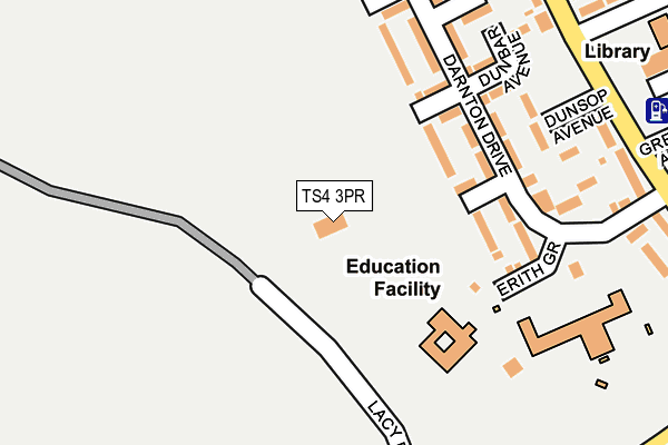
TS4 3PR is located in the Ladgate electoral ward, within the unitary authority of Middlesbrough and the English Parliamentary constituency of Middlesbrough South and East Cleveland. The Sub Integrated Care Board (ICB) Location is NHS North East and North Cumbria ICB - 16C and the police force is Cleveland. This postcode has been in use since July 2013.


GetTheData
Source: OS OpenMap – Local (Ordnance Survey)
Source: OS VectorMap District (Ordnance Survey)
Licence: Open Government Licence (requires attribution)
| Easting | 450492 |
| Northing | 516533 |
| Latitude | 54.541550 |
| Longitude | -1.221076 |
GetTheData
Source: Open Postcode Geo
Licence: Open Government Licence
| Country | England |
| Postcode District | TS4 |
| ➜ TS4 open data dashboard ➜ See where TS4 is on a map ➜ Where is Middlesbrough? | |
GetTheData
Source: Land Registry Price Paid Data
Licence: Open Government Licence
Elevation or altitude of TS4 3PR as distance above sea level:
| Metres | Feet | |
|---|---|---|
| Elevation | 30m | 98ft |
Elevation is measured from the approximate centre of the postcode, to the nearest point on an OS contour line from OS Terrain 50, which has contour spacing of ten vertical metres.
➜ How high above sea level am I? Find the elevation of your current position using your device's GPS.
GetTheData
Source: Open Postcode Elevation
Licence: Open Government Licence
| Ward | Ladgate |
| Constituency | Middlesbrough South And East Cleveland |
GetTheData
Source: ONS Postcode Database
Licence: Open Government Licence
| January 2024 | Violence and sexual offences | On or near Brettenham Avenue | 394m |
| November 2023 | Violence and sexual offences | On or near Brettenham Avenue | 394m |
| November 2023 | Vehicle crime | On or near Brettenham Avenue | 394m |
| ➜ Get more crime data in our Crime section | |||
GetTheData
Source: data.police.uk
Licence: Open Government Licence
| St Agnes Church (Broadwell Road) | Easterside | 277m |
| St Agnes Church (Broadwell Road) | Easterside | 281m |
| St Thomas More School (Broadwell Road) | Easterside | 317m |
| Pensby Avenue (Broadwell Road) | Easterside | 343m |
| Chippenham Road (Broadwell Road) | Easterside | 355m |
| James Cook University Hospital Station | 1.4km |
| Marton Station | 1.5km |
| Gypsy Lane Station | 2.9km |
GetTheData
Source: NaPTAN
Licence: Open Government Licence
GetTheData
Source: ONS Postcode Database
Licence: Open Government Licence

➜ Get more ratings from the Food Standards Agency
GetTheData
Source: Food Standards Agency
Licence: FSA terms & conditions
| Last Collection | |||
|---|---|---|---|
| Location | Mon-Fri | Sat | Distance |
| Tollesby Post Office | 17:15 | 11:30 | 1,299m |
| Coulby Farm Way | 17:00 | 09:45 | 1,438m |
| Eastbourne Road Post Office | 17:15 | 11:15 | 1,942m |
GetTheData
Source: Dracos
Licence: Creative Commons Attribution-ShareAlike
| Facility | Distance |
|---|---|
| Teesside University (Saltersgill Sports Ground) Saltersgill Avenue, Middlesbrough Grass Pitches | 0m |
| Easterside Academy Erith Grove, Middlesbrough Grass Pitches, Outdoor Tennis Courts | 238m |
| Holmwood School Saltersgill Avenue, Middlesbrough Sports Hall, Studio | 331m |
GetTheData
Source: Active Places
Licence: Open Government Licence
| School | Phase of Education | Distance |
|---|---|---|
| St Thomas More RC Primary School Erith Grove, Easterside, Middlesbrough, TS4 3QH | Primary | 157m |
| Easterside Academy Erith Grove, Easterside, Middlesbrough, TS4 3RG | Primary | 220m |
| Holmwood School Saltersgill Avenue, Easterside, Holmwood School, Middlesbrough, TS4 3PT | Not applicable | 331m |
GetTheData
Source: Edubase
Licence: Open Government Licence
The below table lists the International Territorial Level (ITL) codes (formerly Nomenclature of Territorial Units for Statistics (NUTS) codes) and Local Administrative Units (LAU) codes for TS4 3PR:
| ITL 1 Code | Name |
|---|---|
| TLC | North East (England) |
| ITL 2 Code | Name |
| TLC1 | Tees Valley and Durham |
| ITL 3 Code | Name |
| TLC12 | South Teesside |
| LAU 1 Code | Name |
| E06000002 | Middlesbrough |
GetTheData
Source: ONS Postcode Directory
Licence: Open Government Licence
The below table lists the Census Output Area (OA), Lower Layer Super Output Area (LSOA), and Middle Layer Super Output Area (MSOA) for TS4 3PR:
| Code | Name | |
|---|---|---|
| OA | E00060776 | |
| LSOA | E01012052 | Middlesbrough 014D |
| MSOA | E02002509 | Middlesbrough 014 |
GetTheData
Source: ONS Postcode Directory
Licence: Open Government Licence
| TS4 3RJ | Eccleston Walk | 116m |
| TS4 3RQ | Eccleston Walk | 139m |
| TS4 3PF | Epsom Avenue | 149m |
| TS4 3PG | Eccleston Walk | 159m |
| TS4 3RG | Erith Grove | 168m |
| TS4 3PE | Darnton Drive | 175m |
| TS4 3RF | Darnton Drive | 181m |
| TS4 3RL | Dunbar Avenue | 190m |
| TS4 3RN | Dunsop Avenue | 199m |
| TS4 3PB | Elland Avenue | 218m |
GetTheData
Source: Open Postcode Geo; Land Registry Price Paid Data
Licence: Open Government Licence