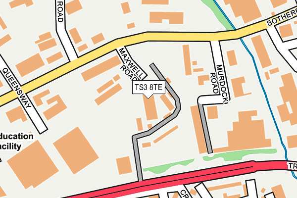
TS3 8TE is located in the Brambles & Thorntree electoral ward, within the unitary authority of Middlesbrough and the English Parliamentary constituency of Middlesbrough. The Sub Integrated Care Board (ICB) Location is NHS North East and North Cumbria ICB - 16C and the police force is Cleveland. This postcode has been in use since July 1986.


GetTheData
Source: OS OpenMap – Local (Ordnance Survey)
Source: OS VectorMap District (Ordnance Survey)
Licence: Open Government Licence (requires attribution)
| Easting | 452491 |
| Northing | 519890 |
| Latitude | 54.571513 |
| Longitude | -1.189584 |
GetTheData
Source: Open Postcode Geo
Licence: Open Government Licence
| Country | England |
| Postcode District | TS3 |
| ➜ TS3 open data dashboard ➜ See where TS3 is on a map ➜ Where is Middlesbrough? | |
GetTheData
Source: Land Registry Price Paid Data
Licence: Open Government Licence
Elevation or altitude of TS3 8TE as distance above sea level:
| Metres | Feet | |
|---|---|---|
| Elevation | 10m | 33ft |
Elevation is measured from the approximate centre of the postcode, to the nearest point on an OS contour line from OS Terrain 50, which has contour spacing of ten vertical metres.
➜ How high above sea level am I? Find the elevation of your current position using your device's GPS.
GetTheData
Source: Open Postcode Elevation
Licence: Open Government Licence
| Ward | Brambles & Thorntree |
| Constituency | Middlesbrough |
GetTheData
Source: ONS Postcode Database
Licence: Open Government Licence
| June 2022 | Vehicle crime | On or near Murdock Road | 128m |
| June 2022 | Other theft | On or near Murdock Road | 128m |
| June 2022 | Vehicle crime | On or near Longlands Road | 180m |
| ➜ Get more crime data in our Crime section | |||
GetTheData
Source: data.police.uk
Licence: Open Government Licence
| Ta Centre (Trunk Road) | Brambles Farm | 165m |
| Ta Centre (Trunk Road) | Brambles Farm | 182m |
| Ferndale Avenue (Marshall Avenue) | Brambles Farm | 376m |
| Cargo Fleet Business Centre (Middlesbrough Road) | Skippers Lane Ind Est | 392m |
| Millbrook Avenue (Marshall Avenue) | Brambles Farm | 394m |
| South Bank Station | 1.6km |
| James Cook University Hospital Station | 2.5km |
| Middlesbrough Station | 3km |
GetTheData
Source: NaPTAN
Licence: Open Government Licence
GetTheData
Source: ONS Postcode Database
Licence: Open Government Licence


➜ Get more ratings from the Food Standards Agency
GetTheData
Source: Food Standards Agency
Licence: FSA terms & conditions
| Last Collection | |||
|---|---|---|---|
| Location | Mon-Fri | Sat | Distance |
| Birchington Avenue P.o. | 17:00 | 12:15 | 1,436m |
| Norfolk Place Post Office | 17:00 | 11:45 | 1,533m |
| North Ormesby Post Office | 18:00 | 12:15 | 1,580m |
GetTheData
Source: Dracos
Licence: Creative Commons Attribution-ShareAlike
| Facility | Distance |
|---|---|
| Polton Training Academy Territorial Street, Middlesbrough Artificial Grass Pitch | 137m |
| Mas Body Gym Metcalfe Road, Skippers Lane Industrial Estate, Middlesbrough Health and Fitness Gym, Studio | 285m |
| The Gym Group (Middlesbrough) Cleveland Retail Park, Skippers Lane Industrial Estate, Middlesbrough Health and Fitness Gym | 409m |
GetTheData
Source: Active Places
Licence: Open Government Licence
| School | Phase of Education | Distance |
|---|---|---|
| Keys Tees Valley College Sotherby Road, Middlesbrough, TS3 8BT | Not applicable | 380m |
| Reintegreat Education Solutions Ltd Brambles Farm Community Centre, Marshall Avenue, Brambles Farm, Middlesbrough, TS3 9AY | Not applicable | 441m |
| Brambles Primary Academy Kedward Avenue, Brambles, Middlesbrough, TS3 9DB | Primary | 670m |
GetTheData
Source: Edubase
Licence: Open Government Licence
The below table lists the International Territorial Level (ITL) codes (formerly Nomenclature of Territorial Units for Statistics (NUTS) codes) and Local Administrative Units (LAU) codes for TS3 8TE:
| ITL 1 Code | Name |
|---|---|
| TLC | North East (England) |
| ITL 2 Code | Name |
| TLC1 | Tees Valley and Durham |
| ITL 3 Code | Name |
| TLC12 | South Teesside |
| LAU 1 Code | Name |
| E06000002 | Middlesbrough |
GetTheData
Source: ONS Postcode Directory
Licence: Open Government Licence
The below table lists the Census Output Area (OA), Lower Layer Super Output Area (LSOA), and Middle Layer Super Output Area (MSOA) for TS3 8TE:
| Code | Name | |
|---|---|---|
| OA | E00060822 | |
| LSOA | E01012060 | Middlesbrough 002C |
| MSOA | E02002497 | Middlesbrough 002 |
GetTheData
Source: ONS Postcode Directory
Licence: Open Government Licence
| TS3 8DR | Brambles Farm | 79m |
| TS3 9DJ | Cherwell Terrace | 205m |
| TS3 9DQ | Cherwell Terrace | 219m |
| TS3 9DL | Cranfield Avenue | 228m |
| TS3 8BL | Telford Road | 241m |
| TS3 9DS | Ferndale Avenue | 242m |
| TS3 9BQ | Pallister Avenue | 291m |
| TS3 9DP | Pallister Avenue | 291m |
| TS3 9DN | Pallister Avenue | 321m |
| TS3 9DT | Ferndale Avenue | 338m |
GetTheData
Source: Open Postcode Geo; Land Registry Price Paid Data
Licence: Open Government Licence