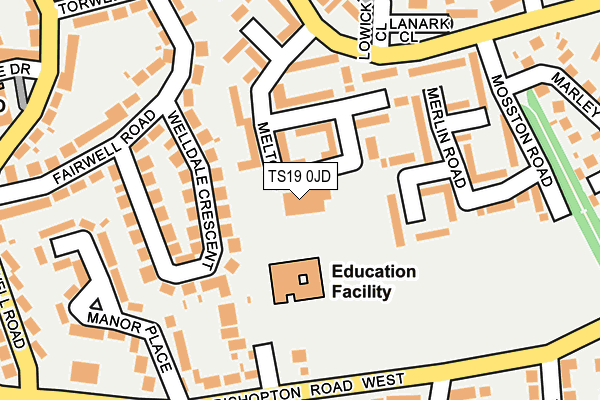
TS19 0JD is located in the Bishopsgarth & Elm Tree electoral ward, within the unitary authority of Stockton-on-Tees and the English Parliamentary constituency of Stockton South. The Sub Integrated Care Board (ICB) Location is NHS North East and North Cumbria ICB - 16C and the police force is Cleveland. This postcode has been in use since October 2004.


GetTheData
Source: OS OpenMap – Local (Ordnance Survey)
Source: OS VectorMap District (Ordnance Survey)
Licence: Open Government Licence (requires attribution)
| Easting | 441788 |
| Northing | 519736 |
| Latitude | 54.571124 |
| Longitude | -1.355146 |
GetTheData
Source: Open Postcode Geo
Licence: Open Government Licence
| Country | England |
| Postcode District | TS19 |
| ➜ TS19 open data dashboard ➜ See where TS19 is on a map ➜ Where is Stockton-on-Tees? | |
GetTheData
Source: Land Registry Price Paid Data
Licence: Open Government Licence
Elevation or altitude of TS19 0JD as distance above sea level:
| Metres | Feet | |
|---|---|---|
| Elevation | 30m | 98ft |
Elevation is measured from the approximate centre of the postcode, to the nearest point on an OS contour line from OS Terrain 50, which has contour spacing of ten vertical metres.
➜ How high above sea level am I? Find the elevation of your current position using your device's GPS.
GetTheData
Source: Open Postcode Elevation
Licence: Open Government Licence
| Ward | Bishopsgarth & Elm Tree |
| Constituency | Stockton South |
GetTheData
Source: ONS Postcode Database
Licence: Open Government Licence
| October 2023 | Violence and sexual offences | On or near Harewood Crescent | 361m |
| October 2023 | Anti-social behaviour | On or near Burdon Close | 431m |
| October 2023 | Anti-social behaviour | On or near Burdon Close | 431m |
| ➜ Get more crime data in our Crime section | |||
GetTheData
Source: data.police.uk
Licence: Open Government Licence
| Lowick Close (Elm Tree Avenue) | Elm Tree | 173m |
| The Vicarage (Bishopton Road) | Fairfield | 183m |
| The Vicarage (Bishopton Road) | Fairfield | 203m |
| The Avenue (Bishopton Road) | Fairfield | 210m |
| Lowick Close (Elm Tree Avenue) | Elm Tree | 210m |
| Stockton Station | 2.4km |
| Thornaby Station | 3.7km |
| Eaglescliffe Station | 4.7km |
GetTheData
Source: NaPTAN
Licence: Open Government Licence
GetTheData
Source: ONS Postcode Database
Licence: Open Government Licence


➜ Get more ratings from the Food Standards Agency
GetTheData
Source: Food Standards Agency
Licence: FSA terms & conditions
| Last Collection | |||
|---|---|---|---|
| Location | Mon-Fri | Sat | Distance |
| Elm Tree Avenue | 16:45 | 11:45 | 195m |
| Wrensfield Road | 17:00 | 12:15 | 1,471m |
| Teesside Ind Estate, Thornaby | 17:45 | 12:15 | 2,031m |
GetTheData
Source: Dracos
Licence: Creative Commons Attribution-ShareAlike
| Facility | Distance |
|---|---|
| St. Marks Elm Tree Ce Va Primary School Bishopton Road West, Stockton-on-tees Grass Pitches | 80m |
| Elmtree Community Centre Elm Tree Avenue, Stockton-on-tees Sports Hall | 417m |
| St Patricks R.c. Primary School Fairfield Road, Stockton-on-tees Grass Pitches | 439m |
GetTheData
Source: Active Places
Licence: Open Government Licence
| School | Phase of Education | Distance |
|---|---|---|
| Green Gates Academy Melton Road, Stockton-on-Tees, TS19 0JD | Not applicable | 6m |
| St Mark's Church of England Primary School St Mark's Close, Bishopton Road West, Fairfield, Stockton-on-Tees, TS19 7HA | Primary | 71m |
| St Patrick's Catholic Primary School, Stockton Fairfield Road, Stockton-on-Tees, TS19 7PL | Primary | 436m |
GetTheData
Source: Edubase
Licence: Open Government Licence
The below table lists the International Territorial Level (ITL) codes (formerly Nomenclature of Territorial Units for Statistics (NUTS) codes) and Local Administrative Units (LAU) codes for TS19 0JD:
| ITL 1 Code | Name |
|---|---|
| TLC | North East (England) |
| ITL 2 Code | Name |
| TLC1 | Tees Valley and Durham |
| ITL 3 Code | Name |
| TLC11 | Hartlepool and Stockton-on-Tees |
| LAU 1 Code | Name |
| E06000004 | Stockton-on-Tees |
GetTheData
Source: ONS Postcode Directory
Licence: Open Government Licence
The below table lists the Census Output Area (OA), Lower Layer Super Output Area (LSOA), and Middle Layer Super Output Area (MSOA) for TS19 0JD:
| Code | Name | |
|---|---|---|
| OA | E00061562 | |
| LSOA | E01012205 | Stockton-on-Tees 011D |
| MSOA | E02002545 | Stockton-on-Tees 011 |
GetTheData
Source: ONS Postcode Directory
Licence: Open Government Licence
| TS19 0TF | Madison Square | 72m |
| TS19 0TE | Markham Square | 103m |
| TS19 7HU | Welldale Crescent | 113m |
| TS19 0TL | Melksham Square | 118m |
| TS19 0TN | Meldrum Square | 124m |
| TS19 7NY | St Mark's Close | 149m |
| TS19 0TD | Medina Close | 157m |
| TS19 0TG | Midfield View | 169m |
| TS19 0TP | Marwood Square | 172m |
| TS19 7HA | Bishopton Road West | 184m |
GetTheData
Source: Open Postcode Geo; Land Registry Price Paid Data
Licence: Open Government Licence