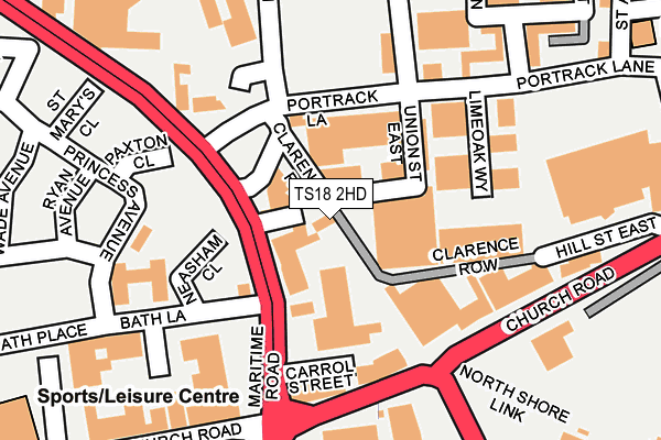
TS18 2HD is located in the Stockton Town Centre electoral ward, within the unitary authority of Stockton-on-Tees and the English Parliamentary constituency of Stockton North. The Sub Integrated Care Board (ICB) Location is NHS North East and North Cumbria ICB - 16C and the police force is Cleveland. This postcode has been in use since December 1996.


GetTheData
Source: OS OpenMap – Local (Ordnance Survey)
Source: OS VectorMap District (Ordnance Survey)
Licence: Open Government Licence (requires attribution)
| Easting | 444962 |
| Northing | 519579 |
| Latitude | 54.569454 |
| Longitude | -1.306093 |
GetTheData
Source: Open Postcode Geo
Licence: Open Government Licence
| Country | England |
| Postcode District | TS18 |
| ➜ TS18 open data dashboard ➜ See where TS18 is on a map ➜ Where is Stockton-on-Tees? | |
GetTheData
Source: Land Registry Price Paid Data
Licence: Open Government Licence
Elevation or altitude of TS18 2HD as distance above sea level:
| Metres | Feet | |
|---|---|---|
| Elevation | 10m | 33ft |
Elevation is measured from the approximate centre of the postcode, to the nearest point on an OS contour line from OS Terrain 50, which has contour spacing of ten vertical metres.
➜ How high above sea level am I? Find the elevation of your current position using your device's GPS.
GetTheData
Source: Open Postcode Elevation
Licence: Open Government Licence
| Ward | Stockton Town Centre |
| Constituency | Stockton North |
GetTheData
Source: ONS Postcode Database
Licence: Open Government Licence
| January 2024 | Violence and sexual offences | On or near Parking Area | 177m |
| January 2024 | Burglary | On or near Parking Area | 177m |
| January 2024 | Burglary | On or near Parking Area | 177m |
| ➜ Get more crime data in our Crime section | |||
GetTheData
Source: data.police.uk
Licence: Open Government Licence
| Stagecoach Depot (Portrack Lane) | Portrack | 226m |
| Stagecoach Depot (Portrack Lane) | Portrack | 228m |
| Church Road | Stockton | 303m |
| Church Road | Stockton | 313m |
| St Mary's Church (Norton Road) | Stockton | 390m |
| Stockton Station | 0.8km |
| Thornaby Station | 1.2km |
| Billingham Station | 4.4km |
GetTheData
Source: NaPTAN
Licence: Open Government Licence
GetTheData
Source: ONS Postcode Database
Licence: Open Government Licence


➜ Get more ratings from the Food Standards Agency
GetTheData
Source: Food Standards Agency
Licence: FSA terms & conditions
| Last Collection | |||
|---|---|---|---|
| Location | Mon-Fri | Sat | Distance |
| St Thomas' Church, Church Road | 18:30 | 12:30 | 501m |
| Yarm Lane | 18:30 | 11:45 | 689m |
| St Cuthberts Road | 17:30 | 11:30 | 728m |
GetTheData
Source: Dracos
Licence: Creative Commons Attribution-ShareAlike
| Facility | Distance |
|---|---|
| Tilery Primary School Northport Road, Northport Road, Stockton-on-tees Grass Pitches | 354m |
| Splash Swimming Pool Church Road, Stockton-on-tees Swimming Pool, Health and Fitness Gym, Studio, Sports Hall | 378m |
| Kiltys Ladies Only Gym (Closed) Bishopton Lane, Stockton-on-tees Health and Fitness Gym, Studio | 534m |
GetTheData
Source: Active Places
Licence: Open Government Licence
| School | Phase of Education | Distance |
|---|---|---|
| Tilery Primary School St Ann's Terrace, Portrack, Stockton-on-Tees, TS18 2HU | Primary | 355m |
| North Shore Academy Talbot Street, Stockton-on-Tees, TS20 2AY | Secondary | 728m |
| Mill Lane Primary School Wellington Street, Stockton-on-Tees, TS18 1QX | Primary | 849m |
GetTheData
Source: Edubase
Licence: Open Government Licence
The below table lists the International Territorial Level (ITL) codes (formerly Nomenclature of Territorial Units for Statistics (NUTS) codes) and Local Administrative Units (LAU) codes for TS18 2HD:
| ITL 1 Code | Name |
|---|---|
| TLC | North East (England) |
| ITL 2 Code | Name |
| TLC1 | Tees Valley and Durham |
| ITL 3 Code | Name |
| TLC11 | Hartlepool and Stockton-on-Tees |
| LAU 1 Code | Name |
| E06000004 | Stockton-on-Tees |
GetTheData
Source: ONS Postcode Directory
Licence: Open Government Licence
The below table lists the Census Output Area (OA), Lower Layer Super Output Area (LSOA), and Middle Layer Super Output Area (MSOA) for TS18 2HD:
| Code | Name | |
|---|---|---|
| OA | E00061856 | |
| LSOA | E01012266 | Stockton-on-Tees 014E |
| MSOA | E02002548 | Stockton-on-Tees 014 |
GetTheData
Source: ONS Postcode Directory
Licence: Open Government Licence
| TS18 2ES | Task Road | 158m |
| TS18 2HP | Portrack Lane | 173m |
| TS20 2AN | The Black Path | 189m |
| TS18 1TW | Church Road | 261m |
| TS18 2HN | Church Road | 264m |
| TS18 2HZ | Baronport Green | 268m |
| TS18 2HX | Northport Road | 278m |
| TS18 2HT | St Anns Terrace | 325m |
| TS18 2JD | Gooseport Road | 336m |
| TS18 2DD | Major Street | 352m |
GetTheData
Source: Open Postcode Geo; Land Registry Price Paid Data
Licence: Open Government Licence