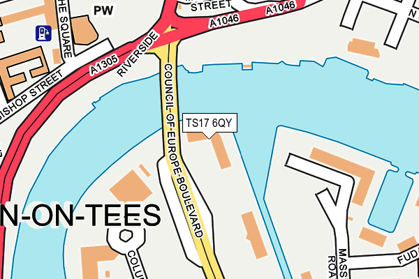
TS17 6QY is located in the Mandale & Victoria electoral ward, within the unitary authority of Stockton-on-Tees and the English Parliamentary constituency of Stockton South. The Sub Integrated Care Board (ICB) Location is NHS North East and North Cumbria ICB - 16C and the police force is Cleveland. This postcode has been in use since December 2001.


GetTheData
Source: OS OpenMap – Local (Ordnance Survey)
Source: OS VectorMap District (Ordnance Survey)
Licence: Open Government Licence (requires attribution)
| Easting | 445017 |
| Northing | 518977 |
| Latitude | 54.564040 |
| Longitude | -1.305334 |
GetTheData
Source: Open Postcode Geo
Licence: Open Government Licence
| Country | England |
| Postcode District | TS17 |
| ➜ TS17 open data dashboard ➜ See where TS17 is on a map ➜ Where is Thornaby-on-Tees? | |
GetTheData
Source: Land Registry Price Paid Data
Licence: Open Government Licence
Elevation or altitude of TS17 6QY as distance above sea level:
| Metres | Feet | |
|---|---|---|
| Elevation | 10m | 33ft |
Elevation is measured from the approximate centre of the postcode, to the nearest point on an OS contour line from OS Terrain 50, which has contour spacing of ten vertical metres.
➜ How high above sea level am I? Find the elevation of your current position using your device's GPS.
GetTheData
Source: Open Postcode Elevation
Licence: Open Government Licence
| Ward | Mandale & Victoria |
| Constituency | Stockton South |
GetTheData
Source: ONS Postcode Database
Licence: Open Government Licence
| January 2024 | Other theft | On or near Castlegate Shopping Centre | 441m |
| January 2024 | Burglary | On or near Parking Area | 475m |
| January 2024 | Burglary | On or near Parking Area | 475m |
| ➜ Get more crime data in our Crime section | |||
GetTheData
Source: data.police.uk
Licence: Open Government Licence
| Dunedin House (Council Of Europe Boulevard) | Teesdale | 85m |
| Dunedin House (Council Of Europe Boulevard) | Teesdale | 98m |
| Columbia Drive | Teesdale | 173m |
| University Boulevard | Teesdale | 208m |
| University Boulevard | Teesdale | 210m |
| Thornaby Station | 0.6km |
| Stockton Station | 1.1km |
| Eaglescliffe Station | 4.8km |
GetTheData
Source: NaPTAN
Licence: Open Government Licence
GetTheData
Source: ONS Postcode Database
Licence: Open Government Licence


➜ Get more ratings from the Food Standards Agency
GetTheData
Source: Food Standards Agency
Licence: FSA terms & conditions
| Last Collection | |||
|---|---|---|---|
| Location | Mon-Fri | Sat | Distance |
| St Cuthberts Road | 17:30 | 11:30 | 379m |
| Harvard Avenue | 17:30 | 11:00 | 386m |
| St Thomas' Church, Church Road | 18:30 | 12:30 | 550m |
GetTheData
Source: Dracos
Licence: Creative Commons Attribution-ShareAlike
| Facility | Distance |
|---|---|
| Elle - All Gym - No Him (Closed) Riverside, Stockton-on-tees Studio, Health and Fitness Gym | 429m |
| Swallow Leisure (Stockton) (Closed) John Walker Square, Stockton-on-tees Health and Fitness Gym, Swimming Pool | 482m |
| Splash Swimming Pool Church Road, Stockton-on-tees Swimming Pool, Health and Fitness Gym, Studio, Sports Hall | 522m |
GetTheData
Source: Active Places
Licence: Open Government Licence
| School | Phase of Education | Distance |
|---|---|---|
| The Education Training Collective Harvard Avenue, Thornaby, Stockton-on-Tees, TS17 6FB | 16 plus | 472m |
| Mill Lane Primary School Wellington Street, Stockton-on-Tees, TS18 1QX | Primary | 831m |
| Tilery Primary School St Ann's Terrace, Portrack, Stockton-on-Tees, TS18 2HU | Primary | 917m |
GetTheData
Source: Edubase
Licence: Open Government Licence
The below table lists the International Territorial Level (ITL) codes (formerly Nomenclature of Territorial Units for Statistics (NUTS) codes) and Local Administrative Units (LAU) codes for TS17 6QY:
| ITL 1 Code | Name |
|---|---|
| TLC | North East (England) |
| ITL 2 Code | Name |
| TLC1 | Tees Valley and Durham |
| ITL 3 Code | Name |
| TLC11 | Hartlepool and Stockton-on-Tees |
| LAU 1 Code | Name |
| E06000004 | Stockton-on-Tees |
GetTheData
Source: ONS Postcode Directory
Licence: Open Government Licence
The below table lists the Census Output Area (OA), Lower Layer Super Output Area (LSOA), and Middle Layer Super Output Area (MSOA) for TS17 6QY:
| Code | Name | |
|---|---|---|
| OA | E00061965 | |
| LSOA | E01012287 | Stockton-on-Tees 017B |
| MSOA | E02002551 | Stockton-on-Tees 017 |
GetTheData
Source: ONS Postcode Directory
Licence: Open Government Licence
| TS17 6EW | Sabatier Close | 224m |
| TS17 6BG | Anchorage Mews | 250m |
| TS17 6QW | St Marks Court | 277m |
| TS17 6EN | Fudan Way | 299m |
| TS17 6BQ | Trinity Mews | 312m |
| TS18 1AS | Finkle Street | 400m |
| TS18 1AR | Finkle Street | 421m |
| TS17 6BS | Radcliffe Crescent | 431m |
| TS18 1TW | Church Road | 435m |
| TS18 1SX | Silver Street | 439m |
GetTheData
Source: Open Postcode Geo; Land Registry Price Paid Data
Licence: Open Government Licence