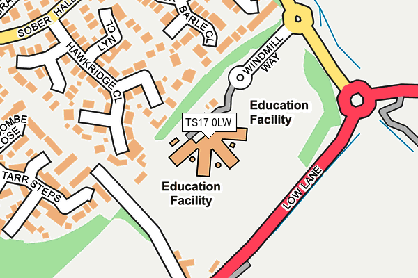
TS17 0LW is located in the Ingleby Barwick South electoral ward, within the unitary authority of Stockton-on-Tees and the English Parliamentary constituency of Stockton South. The Sub Integrated Care Board (ICB) Location is NHS North East and North Cumbria ICB - 16C and the police force is Cleveland. This postcode has been in use since December 2005.


GetTheData
Source: OS OpenMap – Local (Ordnance Survey)
Source: OS VectorMap District (Ordnance Survey)
Licence: Open Government Licence (requires attribution)
| Easting | 444984 |
| Northing | 512645 |
| Latitude | 54.507141 |
| Longitude | -1.306809 |
GetTheData
Source: Open Postcode Geo
Licence: Open Government Licence
| Country | England |
| Postcode District | TS17 |
| ➜ TS17 open data dashboard ➜ See where TS17 is on a map ➜ Where is Ingleby Barwick? | |
GetTheData
Source: Land Registry Price Paid Data
Licence: Open Government Licence
Elevation or altitude of TS17 0LW as distance above sea level:
| Metres | Feet | |
|---|---|---|
| Elevation | 30m | 98ft |
Elevation is measured from the approximate centre of the postcode, to the nearest point on an OS contour line from OS Terrain 50, which has contour spacing of ten vertical metres.
➜ How high above sea level am I? Find the elevation of your current position using your device's GPS.
GetTheData
Source: Open Postcode Elevation
Licence: Open Government Licence
| Ward | Ingleby Barwick South |
| Constituency | Stockton South |
GetTheData
Source: ONS Postcode Database
Licence: Open Government Licence
| August 2023 | Violence and sexual offences | On or near Luccombe Close | 303m |
| July 2023 | Violence and sexual offences | On or near Luccombe Close | 303m |
| June 2022 | Other crime | On or near Barwick Way | 180m |
| ➜ Get more crime data in our Crime section | |||
GetTheData
Source: data.police.uk
Licence: Open Government Licence
| Barwick Way | Ingleby Barwick | 154m |
| Barwick Way | Ingleby Barwick | 234m |
| Brendon Grove (Sober Hall Avenue) | Ingleby Barwick | 236m |
| Brendon Grove (Sober Hall Avenue) | Ingleby Barwick | 265m |
| Fox Covert (Low Lane) | Yarm | 308m |
| Yarm Station | 3.3km |
| Eaglescliffe Station | 3.7km |
| Allens West Station | 4km |
GetTheData
Source: NaPTAN
Licence: Open Government Licence
GetTheData
Source: ONS Postcode Database
Licence: Open Government Licence


➜ Get more ratings from the Food Standards Agency
GetTheData
Source: Food Standards Agency
Licence: FSA terms & conditions
| Last Collection | |||
|---|---|---|---|
| Location | Mon-Fri | Sat | Distance |
| Sober Hall Avenue | 17:00 | 12:00 | 242m |
| Blair Avenue, Thornaby | 17:15 | 12:15 | 887m |
| Beckfield, Thornaby | 17:15 | 12:00 | 1,216m |
GetTheData
Source: Dracos
Licence: Creative Commons Attribution-ShareAlike
| Facility | Distance |
|---|---|
| Ingleby Mill Primary School Windmill Way, Ingleby Barwick, Stockton-on-tees Grass Pitches | 53m |
| Ingleby Manor School Welwyn Road, Ingleby Barwick, Stockton-on-tees Grass Pitches, Sports Hall | 308m |
| Bannatyne Health Club (Ingleby Barwick) Myton Road, Ingleby Barwick, Stockton-on-tees Swimming Pool, Health and Fitness Gym, Studio, Artificial Grass Pitch | 1.3km |
GetTheData
Source: Active Places
Licence: Open Government Licence
| School | Phase of Education | Distance |
|---|---|---|
| Ingleby Mill Primary School Windmill Way, Ingleby Barwick, Stockton-on-Tees, TS17 0LW | Primary | 96m |
| Ingleby Manor Free School & Sixth Form Welwyn Road, Ingleby Barwick, Stockton-on-Tees, TS17 0FA | Secondary | 308m |
| St Therese of Lisieux Catholic Primary School, A Voluntary Catholic Academy Lamb Lane, Ingleby Barwick, Stockton-on-Tees, TS17 0QP | Primary | 1km |
GetTheData
Source: Edubase
Licence: Open Government Licence
The below table lists the International Territorial Level (ITL) codes (formerly Nomenclature of Territorial Units for Statistics (NUTS) codes) and Local Administrative Units (LAU) codes for TS17 0LW:
| ITL 1 Code | Name |
|---|---|
| TLC | North East (England) |
| ITL 2 Code | Name |
| TLC1 | Tees Valley and Durham |
| ITL 3 Code | Name |
| TLC11 | Hartlepool and Stockton-on-Tees |
| LAU 1 Code | Name |
| E06000004 | Stockton-on-Tees |
GetTheData
Source: ONS Postcode Directory
Licence: Open Government Licence
The below table lists the Census Output Area (OA), Lower Layer Super Output Area (LSOA), and Middle Layer Super Output Area (MSOA) for TS17 0LW:
| Code | Name | |
|---|---|---|
| OA | E00061699 | |
| LSOA | E01012233 | Stockton-on-Tees 022C |
| MSOA | E02002556 | Stockton-on-Tees 022 |
GetTheData
Source: ONS Postcode Directory
Licence: Open Government Licence
| TS17 0QX | Danes Brook Court | 76m |
| TS17 0PL | Barle Close | 106m |
| TS17 0QS | Hawkridge Close | 177m |
| TS17 0PH | Brendon Grove | 185m |
| TS17 0QU | Lyn Close | 192m |
| TS17 0PJ | Winsford Court | 211m |
| TS17 0NY | Parracombe Close | 232m |
| TS15 9JR | Barwick Lane | 237m |
| TS17 0QT | Selworthy Green | 252m |
| TS15 9JS | Low Lane | 266m |
GetTheData
Source: Open Postcode Geo; Land Registry Price Paid Data
Licence: Open Government Licence