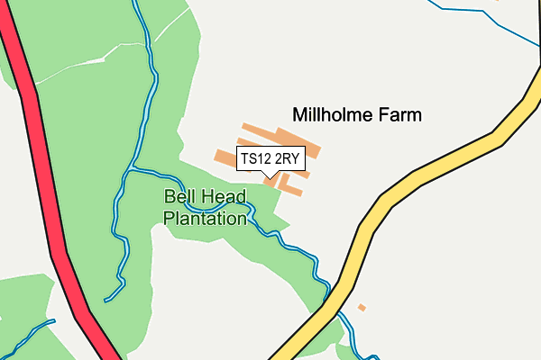
TS12 2RY is located in the Brotton electoral ward, within the unitary authority of Redcar and Cleveland and the English Parliamentary constituency of Middlesbrough South and East Cleveland. The Sub Integrated Care Board (ICB) Location is NHS North East and North Cumbria ICB - 16C and the police force is Cleveland. This postcode has been in use since January 1980.


GetTheData
Source: OS OpenMap – Local (Ordnance Survey)
Source: OS VectorMap District (Ordnance Survey)
Licence: Open Government Licence (requires attribution)
| Easting | 467955 |
| Northing | 519166 |
| Latitude | 54.563170 |
| Longitude | -0.950593 |
GetTheData
Source: Open Postcode Geo
Licence: Open Government Licence
| Country | England |
| Postcode District | TS12 |
| ➜ TS12 open data dashboard ➜ See where TS12 is on a map | |
GetTheData
Source: Land Registry Price Paid Data
Licence: Open Government Licence
Elevation or altitude of TS12 2RY as distance above sea level:
| Metres | Feet | |
|---|---|---|
| Elevation | 60m | 197ft |
Elevation is measured from the approximate centre of the postcode, to the nearest point on an OS contour line from OS Terrain 50, which has contour spacing of ten vertical metres.
➜ How high above sea level am I? Find the elevation of your current position using your device's GPS.
GetTheData
Source: Open Postcode Elevation
Licence: Open Government Licence
| Ward | Brotton |
| Constituency | Middlesbrough South And East Cleveland |
GetTheData
Source: ONS Postcode Database
Licence: Open Government Licence
| June 2022 | Violence and sexual offences | On or near Woodside | 419m |
| June 2022 | Public order | On or near Woodside | 419m |
| May 2022 | Burglary | On or near Woodside | 419m |
| ➜ Get more crime data in our Crime section | |||
GetTheData
Source: data.police.uk
Licence: Open Government Licence
| Woodside (Skelton Road) | Brotton | 401m |
| Woodside (Skelton Road) | Brotton | 489m |
| Linden Road | Brotton | 549m |
| Linden Road | Brotton | 593m |
| Laburnum Road | Brotton | 690m |
| Saltburn Station | 2.7km |
| Marske Station | 5.2km |
GetTheData
Source: NaPTAN
Licence: Open Government Licence
GetTheData
Source: ONS Postcode Database
Licence: Open Government Licence


➜ Get more ratings from the Food Standards Agency
GetTheData
Source: Food Standards Agency
Licence: FSA terms & conditions
| Last Collection | |||
|---|---|---|---|
| Location | Mon-Fri | Sat | Distance |
| Rifts Avenue | 17:15 | 11:30 | 1,775m |
| Cotswold Drive | 16:30 | 10:30 | 1,810m |
| High Street, Skelton | 16:30 | 10:30 | 1,996m |
GetTheData
Source: Dracos
Licence: Creative Commons Attribution-ShareAlike
| Facility | Distance |
|---|---|
| Freebrough Academy Linden Road, Brotton, Saltburn-by-the-sea Grass Pitches, Sports Hall, Outdoor Tennis Courts | 731m |
| St Peters Primary School Marshall Drive, Brotton, Saltburn-by-the-sea Sports Hall, Grass Pitches | 830m |
| North Skelton Playing Field Bluebell Way, Skelton-in-cleveland, Saltburn-by-the-sea Grass Pitches | 1.1km |
GetTheData
Source: Active Places
Licence: Open Government Licence
| School | Phase of Education | Distance |
|---|---|---|
| Freebrough Academy Linden Road, Saltburn-By-the-Sea, TS12 2SJ | Secondary | 731m |
| Kilton Thorpe Specialist Academy Marshall Drive, Brotton, Saltburn-by-the-Sea, TS12 2UW | Not applicable | 794m |
| St Peter's Church of England Primary School Marshall Drive, Brotton, Saltburn-by-the-Sea, TS12 2UW | Primary | 830m |
GetTheData
Source: Edubase
Licence: Open Government Licence
The below table lists the International Territorial Level (ITL) codes (formerly Nomenclature of Territorial Units for Statistics (NUTS) codes) and Local Administrative Units (LAU) codes for TS12 2RY:
| ITL 1 Code | Name |
|---|---|
| TLC | North East (England) |
| ITL 2 Code | Name |
| TLC1 | Tees Valley and Durham |
| ITL 3 Code | Name |
| TLC12 | South Teesside |
| LAU 1 Code | Name |
| E06000003 | Redcar and Cleveland |
GetTheData
Source: ONS Postcode Directory
Licence: Open Government Licence
The below table lists the Census Output Area (OA), Lower Layer Super Output Area (LSOA), and Middle Layer Super Output Area (MSOA) for TS12 2RY:
| Code | Name | |
|---|---|---|
| OA | E00061014 | |
| LSOA | E01012099 | Redcar and Cleveland 010D |
| MSOA | E02002524 | Redcar and Cleveland 010 |
GetTheData
Source: ONS Postcode Directory
Licence: Open Government Licence
| TS12 2RZ | Skelton Road | 342m |
| TS12 2UR | Mill Holme Drive | 345m |
| TS12 2UT | Mill Holme Close | 354m |
| TS12 2RX | Woodside | 458m |
| TS12 2TL | Skelton Road | 469m |
| TS12 2SA | Willow Drive | 510m |
| TS12 2TP | Foster Street | 520m |
| TS12 2TN | Park Road | 536m |
| TS12 2TX | Millholme Terrace | 555m |
| TS12 2TU | Gladstone Street | 560m |
GetTheData
Source: Open Postcode Geo; Land Registry Price Paid Data
Licence: Open Government Licence