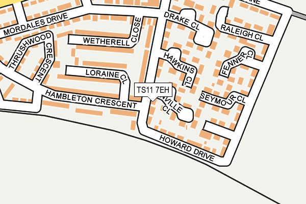
TS11 7EH lies on Howard Drive in Marske By The Sea, Redcar. TS11 7EH is located in the St Germain's electoral ward, within the unitary authority of Redcar and Cleveland and the English Parliamentary constituency of Redcar. The Sub Integrated Care Board (ICB) Location is NHS North East and North Cumbria ICB - 16C and the police force is Cleveland. This postcode has been in use since January 1980.


GetTheData
Source: OS OpenMap – Local (Ordnance Survey)
Source: OS VectorMap District (Ordnance Survey)
Licence: Open Government Licence (requires attribution)
| Easting | 464411 |
| Northing | 521847 |
| Latitude | 54.587723 |
| Longitude | -1.004805 |
GetTheData
Source: Open Postcode Geo
Licence: Open Government Licence
| Street | Howard Drive |
| Locality | Marske By The Sea |
| Town/City | Redcar |
| Country | England |
| Postcode District | TS11 |
| ➜ TS11 open data dashboard ➜ See where TS11 is on a map ➜ Where is Marske-by-the-Sea? | |
GetTheData
Source: Land Registry Price Paid Data
Licence: Open Government Licence
Elevation or altitude of TS11 7EH as distance above sea level:
| Metres | Feet | |
|---|---|---|
| Elevation | 40m | 131ft |
Elevation is measured from the approximate centre of the postcode, to the nearest point on an OS contour line from OS Terrain 50, which has contour spacing of ten vertical metres.
➜ How high above sea level am I? Find the elevation of your current position using your device's GPS.
GetTheData
Source: Open Postcode Elevation
Licence: Open Government Licence
| Ward | St Germain's |
| Constituency | Redcar |
GetTheData
Source: ONS Postcode Database
Licence: Open Government Licence
| September 2023 | Vehicle crime | On or near Grenville Close | 32m |
| July 2023 | Other crime | On or near Grenville Close | 32m |
| February 2023 | Vehicle crime | On or near Hawkins Close | 87m |
| ➜ Get more crime data in our Crime section | |||
GetTheData
Source: data.police.uk
Licence: Open Government Licence
| Howard Drive | Marske | 193m |
| Hambleton Crescent | Marske | 195m |
| Windy Hill Lane | Marske | 265m |
| Church Howle Crescent | Marske | 294m |
| Mordales Drive | Marske | 320m |
| Marske Station | 0.9km |
| Longbeck Station | 1.7km |
| Saltburn Station | 2km |
GetTheData
Source: NaPTAN
Licence: Open Government Licence
| Percentage of properties with Next Generation Access | 100.0% |
| Percentage of properties with Superfast Broadband | 100.0% |
| Percentage of properties with Ultrafast Broadband | 100.0% |
| Percentage of properties with Full Fibre Broadband | 0.0% |
Superfast Broadband is between 30Mbps and 300Mbps
Ultrafast Broadband is > 300Mbps
| Percentage of properties unable to receive 2Mbps | 0.0% |
| Percentage of properties unable to receive 5Mbps | 0.0% |
| Percentage of properties unable to receive 10Mbps | 0.0% |
| Percentage of properties unable to receive 30Mbps | 0.0% |
GetTheData
Source: Ofcom
Licence: Ofcom Terms of Use (requires attribution)
GetTheData
Source: ONS Postcode Database
Licence: Open Government Licence


➜ Get more ratings from the Food Standards Agency
GetTheData
Source: Food Standards Agency
Licence: FSA terms & conditions
| Last Collection | |||
|---|---|---|---|
| Location | Mon-Fri | Sat | Distance |
| Station, Marske | 17:00 | 11:45 | 905m |
| Ship Inn, Marske | 17:15 | 12:00 | 1,182m |
| Marske | 17:00 | 12:15 | 1,184m |
GetTheData
Source: Dracos
Licence: Creative Commons Attribution-ShareAlike
| Facility | Distance |
|---|---|
| Mount Pleasant Stadium Mount Pleasant Avenue, Marske By The Sea Grass Pitches, Outdoor Tennis Courts | 816m |
| Errington Primary School Windy Hill Lane, Marske-by-the-sea, Redcar Grass Pitches | 870m |
| Marske Leisure Centre High Street, Marske-by-the-sea, Redcar Sports Hall, Studio | 998m |
GetTheData
Source: Active Places
Licence: Open Government Licence
| School | Phase of Education | Distance |
|---|---|---|
| Errington Primary School Windy Hill Lane, Marske-by-Sea, Redcar, TS11 7BL | Primary | 870m |
| Invested Education Hall Close, Marske-by-the-Sea, Redcar, Cleveland, TS11 6AB | Not applicable | 1.2km |
| Westgarth Primary School Redcar Road, Marske-by-the-Sea, Redcar, TS11 6AE | Primary | 1.4km |
GetTheData
Source: Edubase
Licence: Open Government Licence
The below table lists the International Territorial Level (ITL) codes (formerly Nomenclature of Territorial Units for Statistics (NUTS) codes) and Local Administrative Units (LAU) codes for TS11 7EH:
| ITL 1 Code | Name |
|---|---|
| TLC | North East (England) |
| ITL 2 Code | Name |
| TLC1 | Tees Valley and Durham |
| ITL 3 Code | Name |
| TLC12 | South Teesside |
| LAU 1 Code | Name |
| E06000003 | Redcar and Cleveland |
GetTheData
Source: ONS Postcode Directory
Licence: Open Government Licence
The below table lists the Census Output Area (OA), Lower Layer Super Output Area (LSOA), and Middle Layer Super Output Area (MSOA) for TS11 7EH:
| Code | Name | |
|---|---|---|
| OA | E00061293 | |
| LSOA | E01012156 | Redcar and Cleveland 006G |
| MSOA | E02002520 | Redcar and Cleveland 006 |
GetTheData
Source: ONS Postcode Directory
Licence: Open Government Licence
| TS11 7JD | Grenville Close | 47m |
| TS11 7EQ | Howard Drive | 90m |
| TS11 7JE | Howard Drive | 92m |
| TS11 7JF | Hawkins Close | 97m |
| TS11 7JL | Loraine Close | 118m |
| TS11 7EG | Frobisher Close | 128m |
| TS11 7JN | Wetherell Close | 136m |
| TS11 7JB | Hambleton Crescent | 140m |
| TS11 7EE | Seymour Close | 141m |
| TS11 7EF | Howard Drive | 161m |
GetTheData
Source: Open Postcode Geo; Land Registry Price Paid Data
Licence: Open Government Licence