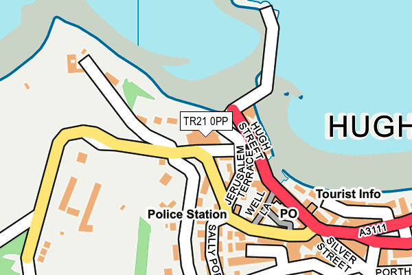
TR21 0PP is located in the St Mary's electoral ward, within the unitary authority of Isles of Scilly and the English Parliamentary constituency of St Ives. The Sub Integrated Care Board (ICB) Location is NHS Cornwall and the Isles of Scilly ICB - 11N and the police force is Devon & Cornwall. This postcode has been in use since January 1995.


GetTheData
Source: OS OpenMap – Local (Ordnance Survey)
Source: OS VectorMap District (Ordnance Survey)
Licence: Open Government Licence (requires attribution)
| Easting | 90100 |
| Northing | 10670 |
| Latitude | 49.915731 |
| Longitude | -6.318530 |
GetTheData
Source: Open Postcode Geo
Licence: Open Government Licence
| Country | England |
| Postcode District | TR21 |
| ➜ TR21 open data dashboard ➜ See where TR21 is on a map ➜ Where is Hugh Town? | |
GetTheData
Source: Land Registry Price Paid Data
Licence: Open Government Licence
Elevation or altitude of TR21 0PP as distance above sea level:
| Metres | Feet | |
|---|---|---|
| Elevation | 10m | 33ft |
Elevation is measured from the approximate centre of the postcode, to the nearest point on an OS contour line from OS Terrain 50, which has contour spacing of ten vertical metres.
➜ How high above sea level am I? Find the elevation of your current position using your device's GPS.
GetTheData
Source: Open Postcode Elevation
Licence: Open Government Licence
| Ward | St Mary's |
| Constituency | St Ives |
GetTheData
Source: ONS Postcode Database
Licence: Open Government Licence
| June 2022 | Anti-social behaviour | On or near Garrison Hill | 20m |
| June 2022 | Public order | On or near Well Lane | 134m |
| June 2022 | Anti-social behaviour | On or near Well Lane | 134m |
| ➜ Get more crime data in our Crime section | |||
GetTheData
Source: data.police.uk
Licence: Open Government Licence
GetTheData
Source: ONS Postcode Database
Licence: Open Government Licence


➜ Get more ratings from the Food Standards Agency
GetTheData
Source: Food Standards Agency
Licence: FSA terms & conditions
| Last Collection | |||
|---|---|---|---|
| Location | Mon-Fri | Sat | Distance |
| The Quay (St Mary's) | 13:00 | 08:00 | 133m |
| Well Cross (St Mary's) | 13:00 | 08:00 | 432m |
| Rosehill (St Mary's) | 13:00 | 08:00 | 928m |
GetTheData
Source: Dracos
Licence: Creative Commons Attribution-ShareAlike
| Facility | Distance |
|---|---|
| Garrison Field Garrison, St. Mary's, Isles Of Scilly Grass Pitches, Outdoor Tennis Courts | 350m |
| Isles Of Scilly Tennis Club Church Road, St. Mary's, Isles Of Scilly Squash Courts, Outdoor Tennis Courts | 639m |
| Carn Gwaval Wellbeing Centre (Queen Elizabeth Ii Community Sports Hall) Church Road, St. Mary's, Isles Of Scilly Health and Fitness Gym, Sports Hall | 1km |
GetTheData
Source: Active Places
Licence: Open Government Licence
| School | Phase of Education | Distance |
|---|---|---|
| The Five Islands Academy Church Road, Old Town, St Mary's, TR21 0NA | All-through | 769m |
GetTheData
Source: Edubase
Licence: Open Government Licence
The below table lists the International Territorial Level (ITL) codes (formerly Nomenclature of Territorial Units for Statistics (NUTS) codes) and Local Administrative Units (LAU) codes for TR21 0PP:
| ITL 1 Code | Name |
|---|---|
| TLK | South West (England) |
| ITL 2 Code | Name |
| TLK3 | Cornwall and Isles of Scilly |
| ITL 3 Code | Name |
| TLK30 | Cornwall and Isles of Scilly |
| LAU 1 Code | Name |
| E06000053 | Isles of Scilly |
GetTheData
Source: ONS Postcode Directory
Licence: Open Government Licence
The below table lists the Census Output Area (OA), Lower Layer Super Output Area (LSOA), and Middle Layer Super Output Area (MSOA) for TR21 0PP:
| Code | Name | |
|---|---|---|
| OA | E00096403 | |
| LSOA | E01019077 | Isles of Scilly 001A |
| MSOA | E02006781 | Isles of Scilly 001 |
GetTheData
Source: ONS Postcode Directory
Licence: Open Government Licence
| TR21 0HY | The Bank | 43m |
| TR21 0JF | Garrison Lane | 70m |
| TR21 0JH | Jerusalem Terrace | 71m |
| TR21 0HZ | Well Lane | 130m |
| TR21 0JD | Garrison Lane | 157m |
| TR21 0LL | Hugh Street | 167m |
| TR21 0JE | 184m | |
| TR21 0JJ | Parsons Field | 196m |
| TR21 0LS | 205m | |
| TR21 0JG | 214m |
GetTheData
Source: Open Postcode Geo; Land Registry Price Paid Data
Licence: Open Government Licence