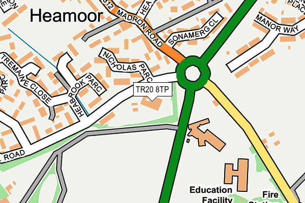
TR20 8TP is located in the Penzance Promenade electoral ward, within the unitary authority of Cornwall and the English Parliamentary constituency of St Ives. The Sub Integrated Care Board (ICB) Location is NHS Cornwall and the Isles of Scilly ICB - 11N and the police force is Devon & Cornwall. This postcode has been in use since January 1980.


GetTheData
Source: OS OpenMap – Local (Ordnance Survey)
Source: OS VectorMap District (Ordnance Survey)
Licence: Open Government Licence (requires attribution)
| Easting | 146432 |
| Northing | 30960 |
| Latitude | 50.124410 |
| Longitude | -5.548999 |
GetTheData
Source: Open Postcode Geo
Licence: Open Government Licence
| Country | England |
| Postcode District | TR20 |
| ➜ TR20 open data dashboard ➜ See where TR20 is on a map ➜ Where is Penzance? | |
GetTheData
Source: Land Registry Price Paid Data
Licence: Open Government Licence
Elevation or altitude of TR20 8TP as distance above sea level:
| Metres | Feet | |
|---|---|---|
| Elevation | 50m | 164ft |
Elevation is measured from the approximate centre of the postcode, to the nearest point on an OS contour line from OS Terrain 50, which has contour spacing of ten vertical metres.
➜ How high above sea level am I? Find the elevation of your current position using your device's GPS.
GetTheData
Source: Open Postcode Elevation
Licence: Open Government Licence
| Ward | Penzance Promenade |
| Constituency | St Ives |
GetTheData
Source: ONS Postcode Database
Licence: Open Government Licence
| June 2022 | Violence and sexual offences | On or near Sports/Recreation Area | 265m |
| June 2022 | Violence and sexual offences | On or near Heabrook Parc | 269m |
| June 2022 | Anti-social behaviour | On or near Parking Area | 271m |
| ➜ Get more crime data in our Crime section | |||
GetTheData
Source: data.police.uk
Licence: Open Government Licence
| Pink Lodge (Nancealverne Road) | Penzance | 54m |
| Pink Lodge | Penzance | 80m |
| John Daniel Centre (Roscadghill Road) | Heamoor | 151m |
| John Daniel Centre (Roscadghill Road) | Heamoor | 171m |
| Sona Merg Close (Madron Road) | Heamoor | 192m |
| Penzance Station | 1.2km |
GetTheData
Source: NaPTAN
Licence: Open Government Licence
GetTheData
Source: ONS Postcode Database
Licence: Open Government Licence


➜ Get more ratings from the Food Standards Agency
GetTheData
Source: Food Standards Agency
Licence: FSA terms & conditions
| Last Collection | |||
|---|---|---|---|
| Location | Mon-Fri | Sat | Distance |
| Tremaine Close | 16:30 | 10:00 | 280m |
| Manor Way | 16:00 | 11:30 | 331m |
| Richmond Street | 16:45 | 11:30 | 367m |
GetTheData
Source: Dracos
Licence: Creative Commons Attribution-ShareAlike
| Facility | Distance |
|---|---|
| Pensans Community Primary School Madron Road, Penzance Grass Pitches | 109m |
| Penzance Cricket Club St Clare Street, Penzance Grass Pitches | 244m |
| Penzance Astro Park St Clare Street, Penzance Artificial Grass Pitch | 364m |
GetTheData
Source: Active Places
Licence: Open Government Licence
| School | Phase of Education | Distance |
|---|---|---|
| Nancealverne School Madron Road, Penzance, TR20 8TP | Not applicable | 13m |
| Pensans Community Primary School Madron Road, Penzance, TR20 8UH | Primary | 127m |
| Humphry Davy School Coombe Road, Penzance, TR18 2TG | Secondary | 578m |
GetTheData
Source: Edubase
Licence: Open Government Licence
The below table lists the International Territorial Level (ITL) codes (formerly Nomenclature of Territorial Units for Statistics (NUTS) codes) and Local Administrative Units (LAU) codes for TR20 8TP:
| ITL 1 Code | Name |
|---|---|
| TLK | South West (England) |
| ITL 2 Code | Name |
| TLK3 | Cornwall and Isles of Scilly |
| ITL 3 Code | Name |
| TLK30 | Cornwall and Isles of Scilly |
| LAU 1 Code | Name |
| E06000052 | Cornwall |
GetTheData
Source: ONS Postcode Directory
Licence: Open Government Licence
The below table lists the Census Output Area (OA), Lower Layer Super Output Area (LSOA), and Middle Layer Super Output Area (MSOA) for TR20 8TP:
| Code | Name | |
|---|---|---|
| OA | E00095969 | |
| LSOA | E01018994 | Cornwall 067C |
| MSOA | E02003948 | Cornwall 067 |
GetTheData
Source: ONS Postcode Directory
Licence: Open Government Licence
| TR18 3HN | Manor Way | 209m |
| TR18 3QL | Sona Merg Close | 212m |
| TR18 3QP | Nicholas Parc | 222m |
| TR18 3HE | Sona Merg Cottages | 243m |
| TR18 3HL | Manor Way | 247m |
| TR18 3DZ | Hea Cottages | 265m |
| TR18 3HF | Hea Corner | 268m |
| TR18 3QR | Heabrook Parc | 276m |
| TR18 3HD | Hea Close | 286m |
| TR18 3HB | Hea Road | 307m |
GetTheData
Source: Open Postcode Geo; Land Registry Price Paid Data
Licence: Open Government Licence