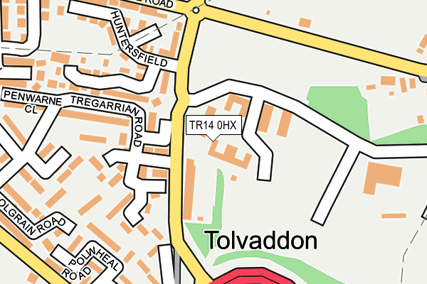
TR14 0HX is located in the Pool & Tehidy electoral ward, within the unitary authority of Cornwall and the English Parliamentary constituency of Camborne and Redruth. The Sub Integrated Care Board (ICB) Location is NHS Cornwall and the Isles of Scilly ICB - 11N and the police force is Devon & Cornwall. This postcode has been in use since July 2002.


GetTheData
Source: OS OpenMap – Local (Ordnance Survey)
Source: OS VectorMap District (Ordnance Survey)
Licence: Open Government Licence (requires attribution)
| Easting | 165914 |
| Northing | 42083 |
| Latitude | 50.232287 |
| Longitude | -5.283766 |
GetTheData
Source: Open Postcode Geo
Licence: Open Government Licence
| Country | England |
| Postcode District | TR14 |
| ➜ TR14 open data dashboard ➜ See where TR14 is on a map ➜ Where is Tolvaddon? | |
GetTheData
Source: Land Registry Price Paid Data
Licence: Open Government Licence
Elevation or altitude of TR14 0HX as distance above sea level:
| Metres | Feet | |
|---|---|---|
| Elevation | 80m | 262ft |
Elevation is measured from the approximate centre of the postcode, to the nearest point on an OS contour line from OS Terrain 50, which has contour spacing of ten vertical metres.
➜ How high above sea level am I? Find the elevation of your current position using your device's GPS.
GetTheData
Source: Open Postcode Elevation
Licence: Open Government Licence
| Ward | Pool & Tehidy |
| Constituency | Camborne And Redruth |
GetTheData
Source: ONS Postcode Database
Licence: Open Government Licence
| June 2022 | Criminal damage and arson | On or near Huntersfield | 185m |
| June 2022 | Violence and sexual offences | On or near Tregarrian Road | 211m |
| June 2022 | Violence and sexual offences | On or near Tregarrian Road | 211m |
| ➜ Get more crime data in our Crime section | |||
GetTheData
Source: data.police.uk
Licence: Open Government Licence
| Tolvaddon Energy Park | Tolvaddon | 66m |
| Tolvaddon Energy Park | Tolvaddon | 72m |
| Tregarrian Road | Roskear Croft | 113m |
| Tregarrian Road | Roskear Croft | 116m |
| Penwarne Close (Tregarrian Road) | Roskear Croft | 249m |
| Camborne Station | 2.6km |
| Redruth Station | 4.1km |
GetTheData
Source: NaPTAN
Licence: Open Government Licence
GetTheData
Source: ONS Postcode Database
Licence: Open Government Licence


➜ Get more ratings from the Food Standards Agency
GetTheData
Source: Food Standards Agency
Licence: FSA terms & conditions
| Last Collection | |||
|---|---|---|---|
| Location | Mon-Fri | Sat | Distance |
| Pool | 17:00 | 11:30 | 672m |
| Tuckingmill | 17:00 | 11:00 | 1,003m |
| Tesco | 16:30 | 10:30 | 1,474m |
GetTheData
Source: Dracos
Licence: Creative Commons Attribution-ShareAlike
| Facility | Distance |
|---|---|
| Cornwall College (Camborne) Trevenson Campus, Pool, Redruth Health and Fitness Gym, Grass Pitches, Sports Hall, Artificial Grass Pitch, Studio | 534m |
| Pool Academy Church Road Pool, Redruth Sports Hall, Artificial Grass Pitch, Grass Pitches, Studio, Health and Fitness Gym | 897m |
| Camborne Cricket Club North Roskear Road, Camborne Grass Pitches | 1.2km |
GetTheData
Source: Active Places
Licence: Open Government Licence
| School | Phase of Education | Distance |
|---|---|---|
| Pool Academy Church Road, Pool, Redruth, TR15 3PZ | Secondary | 999m |
| Rosemellin Community Primary School Cliff View Road, Camborne, TR14 8PG | Primary | 1.3km |
| Roskear School Roskear, Camborne, TR14 8DJ | Primary | 1.7km |
GetTheData
Source: Edubase
Licence: Open Government Licence
The below table lists the International Territorial Level (ITL) codes (formerly Nomenclature of Territorial Units for Statistics (NUTS) codes) and Local Administrative Units (LAU) codes for TR14 0HX:
| ITL 1 Code | Name |
|---|---|
| TLK | South West (England) |
| ITL 2 Code | Name |
| TLK3 | Cornwall and Isles of Scilly |
| ITL 3 Code | Name |
| TLK30 | Cornwall and Isles of Scilly |
| LAU 1 Code | Name |
| E06000052 | Cornwall |
GetTheData
Source: ONS Postcode Directory
Licence: Open Government Licence
The below table lists the Census Output Area (OA), Lower Layer Super Output Area (LSOA), and Middle Layer Super Output Area (MSOA) for TR14 0HX:
| Code | Name | |
|---|---|---|
| OA | E00095381 | |
| LSOA | E01018891 | Cornwall 045C |
| MSOA | E02003918 | Cornwall 045 |
GetTheData
Source: ONS Postcode Directory
Licence: Open Government Licence
| TR14 0EH | 84m | |
| TR14 0HD | Tregarrian Road | 129m |
| TR14 0EN | Penrose Court | 140m |
| TR14 0HB | Treberran Gardens | 170m |
| TR14 0EL | Pengeron Avenue | 172m |
| TR14 0HW | Huntersfield | 175m |
| TR14 0HF | Tresawla Court | 208m |
| TR14 0EY | Rosemullion Gardens | 224m |
| TR14 0EP | Cross Roads | 232m |
| TR14 0EU | Polwheal Road | 247m |
GetTheData
Source: Open Postcode Geo; Land Registry Price Paid Data
Licence: Open Government Licence