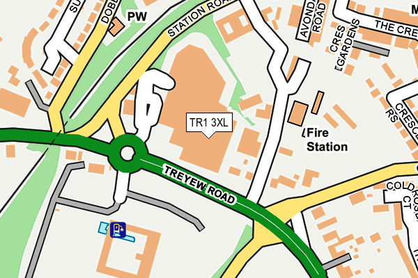
TR1 3XL is located in the Truro Boscawen & Redannick electoral ward, within the unitary authority of Cornwall and the English Parliamentary constituency of Truro and Falmouth. The Sub Integrated Care Board (ICB) Location is NHS Cornwall and the Isles of Scilly ICB - 11N and the police force is Devon & Cornwall. This postcode has been in use since December 1994.


GetTheData
Source: OS OpenMap – Local (Ordnance Survey)
Source: OS VectorMap District (Ordnance Survey)
Licence: Open Government Licence (requires attribution)
| Easting | 181454 |
| Northing | 44668 |
| Latitude | 50.261461 |
| Longitude | -5.067648 |
GetTheData
Source: Open Postcode Geo
Licence: Open Government Licence
| Country | England |
| Postcode District | TR1 |
| ➜ TR1 open data dashboard ➜ See where TR1 is on a map ➜ Where is Truro? | |
GetTheData
Source: Land Registry Price Paid Data
Licence: Open Government Licence
Elevation or altitude of TR1 3XL as distance above sea level:
| Metres | Feet | |
|---|---|---|
| Elevation | 60m | 197ft |
Elevation is measured from the approximate centre of the postcode, to the nearest point on an OS contour line from OS Terrain 50, which has contour spacing of ten vertical metres.
➜ How high above sea level am I? Find the elevation of your current position using your device's GPS.
GetTheData
Source: Open Postcode Elevation
Licence: Open Government Licence
| Ward | Truro Boscawen & Redannick |
| Constituency | Truro And Falmouth |
GetTheData
Source: ONS Postcode Database
Licence: Open Government Licence
| August 2022 | Other theft | On or near Hillcrest Avenue | 402m |
| July 2022 | Vehicle crime | On or near Hillcrest Avenue | 402m |
| July 2022 | Anti-social behaviour | On or near Hillcrest Avenue | 402m |
| ➜ Get more crime data in our Crime section | |||
GetTheData
Source: data.police.uk
Licence: Open Government Licence
| Sainsbury's Treyew Road | Truro | 50m |
| Sainsburys Car Park (Car Park) | Truro | 88m |
| Sainsbury (Station Road) | Truro | 155m |
| Sainsbury (Station Road) | Truro | 165m |
| Top Of Chapel Hill (Chapel Hill) | Truro | 174m |
| Truro Station | 0.3km |
| Perranwell Station | 5.9km |
GetTheData
Source: NaPTAN
Licence: Open Government Licence
GetTheData
Source: ONS Postcode Database
Licence: Open Government Licence


➜ Get more ratings from the Food Standards Agency
GetTheData
Source: Food Standards Agency
Licence: FSA terms & conditions
| Last Collection | |||
|---|---|---|---|
| Location | Mon-Fri | Sat | Distance |
| Treyew Road | 16:45 | 12:10 | 177m |
| Railway Station | 17:00 | 11:35 | 372m |
| Hendra Post Office | 17:00 | 11:55 | 625m |
GetTheData
Source: Dracos
Licence: Creative Commons Attribution-ShareAlike
| Facility | Distance |
|---|---|
| Treyew Road Treyew Road, Truro Grass Pitches | 283m |
| Truro Learning Academy Albany Road, Truro Grass Pitches | 375m |
| Bosvigo Primary School Playing Fields Chapel Hill, Truro Grass Pitches | 584m |
GetTheData
Source: Active Places
Licence: Open Government Licence
| School | Phase of Education | Distance |
|---|---|---|
| Community & Hospital Education Service Ap Academy Treyew Road, Truro, TR1 3AS | Not applicable | 58m |
| Truro Learning Academy Albany Road, Malabar, Truro, TR1 3PQ | Primary | 442m |
| Bosvigo School Chapel Hill, Truro, TR1 3BJ | Primary | 584m |
GetTheData
Source: Edubase
Licence: Open Government Licence
The below table lists the International Territorial Level (ITL) codes (formerly Nomenclature of Territorial Units for Statistics (NUTS) codes) and Local Administrative Units (LAU) codes for TR1 3XL:
| ITL 1 Code | Name |
|---|---|
| TLK | South West (England) |
| ITL 2 Code | Name |
| TLK3 | Cornwall and Isles of Scilly |
| ITL 3 Code | Name |
| TLK30 | Cornwall and Isles of Scilly |
| LAU 1 Code | Name |
| E06000052 | Cornwall |
GetTheData
Source: ONS Postcode Directory
Licence: Open Government Licence
The below table lists the Census Output Area (OA), Lower Layer Super Output Area (LSOA), and Middle Layer Super Output Area (MSOA) for TR1 3XL:
| Code | Name | |
|---|---|---|
| OA | E00094943 | |
| LSOA | E01018810 | Cornwall 044D |
| MSOA | E02003910 | Cornwall 044 |
GetTheData
Source: ONS Postcode Directory
Licence: Open Government Licence
| TR1 3AN | Treyew Road | 113m |
| TR1 3EU | Avondale Road | 235m |
| TR1 3NS | Hayne Corfe Gardens | 236m |
| TR1 3ET | Crescent Gardens | 238m |
| TR1 3NA | Dobbs Lane | 255m |
| TR1 3EX | Station Road | 257m |
| TR1 2LE | Coldrose Court | 287m |
| TR1 3ER | Crescent Rise | 292m |
| TR1 3FJ | Hayne Corfe Crescent | 295m |
| TR1 3NP | Tre El Vern Close | 298m |
GetTheData
Source: Open Postcode Geo; Land Registry Price Paid Data
Licence: Open Government Licence