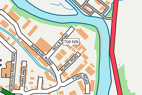
TQ9 5XN is located in the Totnes electoral ward, within the local authority district of South Hams and the English Parliamentary constituency of Totnes. The Sub Integrated Care Board (ICB) Location is NHS Devon ICB - 15N and the police force is Devon & Cornwall. This postcode has been in use since September 1981.


GetTheData
Source: OS OpenMap – Local (Ordnance Survey)
Source: OS VectorMap District (Ordnance Survey)
Licence: Open Government Licence (requires attribution)
| Easting | 280629 |
| Northing | 60881 |
| Latitude | 50.435592 |
| Longitude | -3.682239 |
GetTheData
Source: Open Postcode Geo
Licence: Open Government Licence
| Country | England |
| Postcode District | TQ9 |
➜ See where TQ9 is on a map ➜ Where is Totnes? | |
GetTheData
Source: Land Registry Price Paid Data
Licence: Open Government Licence
Elevation or altitude of TQ9 5XN as distance above sea level:
| Metres | Feet | |
|---|---|---|
| Elevation | 10m | 33ft |
Elevation is measured from the approximate centre of the postcode, to the nearest point on an OS contour line from OS Terrain 50, which has contour spacing of ten vertical metres.
➜ How high above sea level am I? Find the elevation of your current position using your device's GPS.
GetTheData
Source: Open Postcode Elevation
Licence: Open Government Licence
| Ward | Totnes |
| Constituency | Totnes |
GetTheData
Source: ONS Postcode Database
Licence: Open Government Licence
| Leatside Surgery (Babbage Road) | Totnes | 186m |
| Pavilions Leisure Centre (Borough Park Road) | Totnes | 247m |
| Morrisons | Totnes | 303m |
| Rail Station Forecourt (Station Approach) | Totnes | 444m |
| Opposite Tourist Information Centre (Coronation Road) | Totnes | 452m |
| Totnes (South Devon Railway) | Totnes | 461m |
| Totnes Station | 0.5km |
GetTheData
Source: NaPTAN
Licence: Open Government Licence
| Median download speed | 21.7Mbps |
| Average download speed | 33.7Mbps |
| Maximum download speed | 80.00Mbps |
| Median upload speed | 1.3Mbps |
| Average upload speed | 7.3Mbps |
| Maximum upload speed | 20.00Mbps |
GetTheData
Source: Ofcom
Licence: Ofcom Terms of Use (requires attribution)
Estimated total energy consumption in TQ9 5XN by fuel type, 2015.
| Consumption (kWh) | 66,349 |
|---|---|
| Meter count | 8 |
| Mean (kWh/meter) | 8,294 |
| Median (kWh/meter) | 3,942 |
GetTheData
Source: Postcode level gas estimates: 2015 (experimental)
Source: Postcode level electricity estimates: 2015 (experimental)
Licence: Open Government Licence
GetTheData
Source: ONS Postcode Database
Licence: Open Government Licence


➜ Get more ratings from the Food Standards Agency
GetTheData
Source: Food Standards Agency
Licence: FSA terms & conditions
| Last Collection | |||
|---|---|---|---|
| Location | Mon-Fri | Sat | Distance |
| Station Road | 18:00 | 12:15 | 317m |
| Totnes Delivery Office | 18:30 | 12:00 | 330m |
| The Plains | 18:15 | 12:00 | 572m |
GetTheData
Source: Dracos
Licence: Creative Commons Attribution-ShareAlike
| Risk of TQ9 5XN flooding from rivers and sea | Medium |
| ➜ TQ9 5XN flood map | |
GetTheData
Source: Open Flood Risk by Postcode
Licence: Open Government Licence
The below table lists the International Territorial Level (ITL) codes (formerly Nomenclature of Territorial Units for Statistics (NUTS) codes) and Local Administrative Units (LAU) codes for TQ9 5XN:
| ITL 1 Code | Name |
|---|---|
| TLK | South West (England) |
| ITL 2 Code | Name |
| TLK4 | Devon |
| ITL 3 Code | Name |
| TLK43 | Devon CC |
| LAU 1 Code | Name |
| E07000044 | South Hams |
GetTheData
Source: ONS Postcode Directory
Licence: Open Government Licence
The below table lists the Census Output Area (OA), Lower Layer Super Output Area (LSOA), and Middle Layer Super Output Area (MSOA) for TQ9 5XN:
| Code | Name | |
|---|---|---|
| OA | E00102216 | |
| LSOA | E01020180 | South Hams 003A |
| MSOA | E02004191 | South Hams 003 |
GetTheData
Source: ONS Postcode Directory
Licence: Open Government Licence
| TQ9 5XL | Burke Road | 53m |
| TQ9 5XT | The Paddocks | 99m |
| TQ9 5HZ | Parklands | 214m |
| TQ9 5LQ | Ford Road | 230m |
| TQ9 5XW | Borough Park Road | 273m |
| TQ9 5DH | Colebrook Cottages | 309m |
| TQ9 5GH | Coronation Road | 345m |
| TQ9 5GN | Coronation Road | 382m |
| TQ9 5JG | Station Road | 411m |
| TQ9 5DF | Coronation Road | 412m |
GetTheData
Source: Open Postcode Geo; Land Registry Price Paid Data
Licence: Open Government Licence