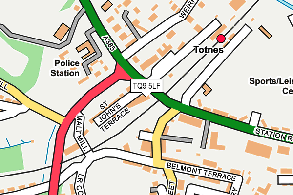
TQ9 5LF lies on Station Road in Totnes. TQ9 5LF is located in the Totnes electoral ward, within the local authority district of South Hams and the English Parliamentary constituency of Totnes. The Sub Integrated Care Board (ICB) Location is NHS Devon ICB - 15N and the police force is Devon & Cornwall. This postcode has been in use since January 1980.


GetTheData
Source: OS OpenMap – Local (Ordnance Survey)
Source: OS VectorMap District (Ordnance Survey)
Licence: Open Government Licence (requires attribution)
| Easting | 280004 |
| Northing | 60795 |
| Latitude | 50.434706 |
| Longitude | -3.690989 |
GetTheData
Source: Open Postcode Geo
Licence: Open Government Licence
| Street | Station Road |
| Town/City | Totnes |
| Country | England |
| Postcode District | TQ9 |
| ➜ TQ9 open data dashboard ➜ See where TQ9 is on a map ➜ Where is Totnes? | |
GetTheData
Source: Land Registry Price Paid Data
Licence: Open Government Licence
Elevation or altitude of TQ9 5LF as distance above sea level:
| Metres | Feet | |
|---|---|---|
| Elevation | 10m | 33ft |
Elevation is measured from the approximate centre of the postcode, to the nearest point on an OS contour line from OS Terrain 50, which has contour spacing of ten vertical metres.
➜ How high above sea level am I? Find the elevation of your current position using your device's GPS.
GetTheData
Source: Open Postcode Elevation
Licence: Open Government Licence
| Ward | Totnes |
| Constituency | Totnes |
GetTheData
Source: ONS Postcode Database
Licence: Open Government Licence
| September 2022 | Violence and sexual offences | On or near South Street | 465m |
| September 2022 | Vehicle crime | On or near South Street | 465m |
| July 2022 | Violence and sexual offences | On or near South Street | 465m |
| ➜ Station Road crime map and outcomes | |||
GetTheData
Source: data.police.uk
Licence: Open Government Licence
| Rail Station (A381) | Totnes | 36m |
| Rail Station (Station Road) | Totnes | 139m |
| Barracks Hill | Swallowfields | 190m |
| Rail Station Forecourt (Station Approach) | Totnes | 219m |
| Barracks Hill | Swallowfields | 234m |
| Totnes (South Devon Railway) | Totnes | 597m |
| Totnes Station | 0.2km |
GetTheData
Source: NaPTAN
Licence: Open Government Licence
GetTheData
Source: ONS Postcode Database
Licence: Open Government Licence


➜ Get more ratings from the Food Standards Agency
GetTheData
Source: Food Standards Agency
Licence: FSA terms & conditions
| Last Collection | |||
|---|---|---|---|
| Location | Mon-Fri | Sat | Distance |
| Unigate | 17:45 | 12:15 | 53m |
| Butterwalk | 18:00 | 12:15 | 351m |
| Station Road | 18:00 | 12:15 | 369m |
GetTheData
Source: Dracos
Licence: Creative Commons Attribution-ShareAlike
| Facility | Distance |
|---|---|
| Totnes Leisure Centre Borough Park Road, Totnes Sports Hall, Swimming Pool, Health and Fitness Gym, Grass Pitches, Outdoor Tennis Courts, Studio | 359m |
| King Edward Vi Community College Ashburton Road, Totnes Grass Pitches, Sports Hall, Artificial Grass Pitch, Studio, Health and Fitness Gym | 475m |
| Totnes St Johns Church Of England Primary School Pathfields, Totnes Grass Pitches | 1.2km |
GetTheData
Source: Active Places
Licence: Open Government Licence
| School | Phase of Education | Distance |
|---|---|---|
| Totnes Progressive School Windmill House, 21 Ashburton Road, Totnes, Totnes, TQ9 5JT | Not applicable | 205m |
| King Edward VI Community College Ashburton Road, Totnes, TQ9 5JX | Secondary | 475m |
| The Grove School The Grove, Totnes, TQ9 5ED | Primary | 516m |
GetTheData
Source: Edubase
Licence: Open Government Licence
The below table lists the International Territorial Level (ITL) codes (formerly Nomenclature of Territorial Units for Statistics (NUTS) codes) and Local Administrative Units (LAU) codes for TQ9 5LF:
| ITL 1 Code | Name |
|---|---|
| TLK | South West (England) |
| ITL 2 Code | Name |
| TLK4 | Devon |
| ITL 3 Code | Name |
| TLK43 | Devon CC |
| LAU 1 Code | Name |
| E07000044 | South Hams |
GetTheData
Source: ONS Postcode Directory
Licence: Open Government Licence
The below table lists the Census Output Area (OA), Lower Layer Super Output Area (LSOA), and Middle Layer Super Output Area (MSOA) for TQ9 5LF:
| Code | Name | |
|---|---|---|
| OA | E00102216 | |
| LSOA | E01020180 | South Hams 003A |
| MSOA | E02004191 | South Hams 003 |
GetTheData
Source: ONS Postcode Directory
Licence: Open Government Licence
| TQ9 5EQ | Redworth Court | 37m |
| TQ9 5JH | St Johns Terrace | 62m |
| TQ9 5JN | Redworth Terrace | 76m |
| TQ9 5QW | Kistor Gardens | 78m |
| TQ9 5GS | Barn Close | 87m |
| TQ9 5DB | Bridge Court | 92m |
| TQ9 5JQ | Queens Terrace | 98m |
| TQ9 5JJ | Argyle Terrace | 103m |
| TQ9 5JW | Radnor Terrace | 103m |
| TQ9 5PY | Glenarm Terrace | 106m |
GetTheData
Source: Open Postcode Geo; Land Registry Price Paid Data
Licence: Open Government Licence