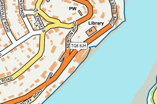
TQ8 8JH is located in the Salcombe & Thurlestone electoral ward, within the local authority district of South Hams and the English Parliamentary constituency of Totnes. The Sub Integrated Care Board (ICB) Location is NHS Devon ICB - 15N and the police force is Devon & Cornwall. This postcode has been in use since January 1980.


GetTheData
Source: OS OpenMap – Local (Ordnance Survey)
Source: OS VectorMap District (Ordnance Survey)
Licence: Open Government Licence (requires attribution)
| Easting | 273969 |
| Northing | 38743 |
| Latitude | 50.235215 |
| Longitude | -3.768546 |
GetTheData
Source: Open Postcode Geo
Licence: Open Government Licence
| Country | England |
| Postcode District | TQ8 |
| ➜ TQ8 open data dashboard ➜ See where TQ8 is on a map ➜ Where is Salcombe? | |
GetTheData
Source: Land Registry Price Paid Data
Licence: Open Government Licence
Elevation or altitude of TQ8 8JH as distance above sea level:
| Metres | Feet | |
|---|---|---|
| Elevation | 20m | 66ft |
Elevation is measured from the approximate centre of the postcode, to the nearest point on an OS contour line from OS Terrain 50, which has contour spacing of ten vertical metres.
➜ How high above sea level am I? Find the elevation of your current position using your device's GPS.
GetTheData
Source: Open Postcode Elevation
Licence: Open Government Licence
| Ward | Salcombe & Thurlestone |
| Constituency | Totnes |
GetTheData
Source: ONS Postcode Database
Licence: Open Government Licence
THE BEACH HOUSE, CLIFF ROAD, SALCOMBE, TQ8 8JH 2019 15 NOV £1,100,000 |
GetTheData
Source: HM Land Registry Price Paid Data
Licence: Contains HM Land Registry data © Crown copyright and database right 2024. This data is licensed under the Open Government Licence v3.0.
| June 2022 | Criminal damage and arson | On or near Parking Area | 305m |
| April 2022 | Anti-social behaviour | On or near Cliff Road | 17m |
| April 2022 | Anti-social behaviour | On or near Normandy Way | 295m |
| ➜ Get more crime data in our Crime section | |||
GetTheData
Source: data.police.uk
Licence: Open Government Licence
| Herbert Road (Devon Road) | Salcombe | 143m |
| Herbert Road (Devon Road) | Salcombe | 146m |
| Devon Court (Devon Road) | Salcombe | 271m |
| Devon Court (Devon Road) | Salcombe | 280m |
| Tourist Information Centre (Church Street) | Salcombe | 419m |
GetTheData
Source: NaPTAN
Licence: Open Government Licence
GetTheData
Source: ONS Postcode Database
Licence: Open Government Licence


➜ Get more ratings from the Food Standards Agency
GetTheData
Source: Food Standards Agency
Licence: FSA terms & conditions
| Last Collection | |||
|---|---|---|---|
| Location | Mon-Fri | Sat | Distance |
| Salcombe Post Office | 17:00 | 11:45 | 291m |
| Woodcot Cliff Road | 10:45 | 10:45 | 351m |
| Ferry Steps | 11:30 | 11:30 | 359m |
GetTheData
Source: Dracos
Licence: Creative Commons Attribution-ShareAlike
| Facility | Distance |
|---|---|
| The Salcombe Harbour Hotel Cliff Road, Salcombe Health and Fitness Gym, Swimming Pool | 0m |
| Salcombe Rugby Football Club Camperdown Road, Salcombe Grass Pitches | 424m |
| Salcombe Swimming Pool Onslow Road, Salcombe Swimming Pool | 706m |
GetTheData
Source: Active Places
Licence: Open Government Licence
| School | Phase of Education | Distance |
|---|---|---|
| Salcombe Church of England Primary School Onslow Road, Salcombe, TQ8 8AG | Primary | 686m |
| Malborough with South Huish Church of England Primary School Higher Town, Malborough, Kingsbridge, TQ7 3RN | Primary | 3.3km |
| Charleton Church of England Academy West Charleton, Kingsbridge, TQ7 2AL | Primary | 4.2km |
GetTheData
Source: Edubase
Licence: Open Government Licence
The below table lists the International Territorial Level (ITL) codes (formerly Nomenclature of Territorial Units for Statistics (NUTS) codes) and Local Administrative Units (LAU) codes for TQ8 8JH:
| ITL 1 Code | Name |
|---|---|
| TLK | South West (England) |
| ITL 2 Code | Name |
| TLK4 | Devon |
| ITL 3 Code | Name |
| TLK43 | Devon CC |
| LAU 1 Code | Name |
| E07000044 | South Hams |
GetTheData
Source: ONS Postcode Directory
Licence: Open Government Licence
The below table lists the Census Output Area (OA), Lower Layer Super Output Area (LSOA), and Middle Layer Super Output Area (MSOA) for TQ8 8JH:
| Code | Name | |
|---|---|---|
| OA | E00102170 | |
| LSOA | E01020173 | South Hams 012B |
| MSOA | E02004200 | South Hams 012 |
GetTheData
Source: ONS Postcode Directory
Licence: Open Government Licence
| TQ8 8GY | Estura | 28m |
| TQ8 8JQ | Cliff Road | 29m |
| TQ8 8HH | Newton Road | 77m |
| TQ8 8JZ | Cliff Road | 104m |
| TQ8 8GZ | Devon Road | 129m |
| TQ8 8HF | Garden Close | 150m |
| TQ8 8JY | Cliff Road | 159m |
| TQ8 8HL | Devon Road | 161m |
| TQ8 8HT | Allenhayes Road | 167m |
| TQ8 8HQ | Devon Road | 180m |
GetTheData
Source: Open Postcode Geo; Land Registry Price Paid Data
Licence: Open Government Licence