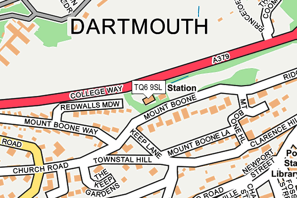
TQ6 9SL is located in the Dartmouth & East Dart electoral ward, within the local authority district of South Hams and the English Parliamentary constituency of Totnes. The Sub Integrated Care Board (ICB) Location is NHS Devon ICB - 15N and the police force is Devon & Cornwall. This postcode has been in use since February 1984.


GetTheData
Source: OS OpenMap – Local (Ordnance Survey)
Source: OS VectorMap District (Ordnance Survey)
Licence: Open Government Licence (requires attribution)
| Easting | 287427 |
| Northing | 51600 |
| Latitude | 50.353500 |
| Longitude | -3.583770 |
GetTheData
Source: Open Postcode Geo
Licence: Open Government Licence
| Country | England |
| Postcode District | TQ6 |
| ➜ TQ6 open data dashboard ➜ See where TQ6 is on a map ➜ Where is Dartmouth? | |
GetTheData
Source: Land Registry Price Paid Data
Licence: Open Government Licence
Elevation or altitude of TQ6 9SL as distance above sea level:
| Metres | Feet | |
|---|---|---|
| Elevation | 50m | 164ft |
Elevation is measured from the approximate centre of the postcode, to the nearest point on an OS contour line from OS Terrain 50, which has contour spacing of ten vertical metres.
➜ How high above sea level am I? Find the elevation of your current position using your device's GPS.
GetTheData
Source: Open Postcode Elevation
Licence: Open Government Licence
| Ward | Dartmouth & East Dart |
| Constituency | Totnes |
GetTheData
Source: ONS Postcode Database
Licence: Open Government Licence
| June 2022 | Public order | On or near Clarence Hill | 217m |
| June 2022 | Anti-social behaviour | On or near Newport Street | 267m |
| June 2022 | Violence and sexual offences | On or near Police Station | 342m |
| ➜ Get more crime data in our Crime section | |||
GetTheData
Source: data.police.uk
Licence: Open Government Licence
| Bowling Green (Victoria Road) | Dartmouth | 310m |
| Bowling Green (Victoria Road) | Dartmouth | 311m |
| Seale Arms (Victoria Road) | Dartmouth | 317m |
| Spar (Victoria Road) | Dartmouth | 337m |
| Beechfield Terrace (Townstal Road) | Townstal | 350m |
| Kingswear (Paignton And Dartmouth Railway) (Fore Street) | Kingswear | 932m |
GetTheData
Source: NaPTAN
Licence: Open Government Licence
GetTheData
Source: ONS Postcode Database
Licence: Open Government Licence

➜ Get more ratings from the Food Standards Agency
GetTheData
Source: Food Standards Agency
Licence: FSA terms & conditions
| Last Collection | |||
|---|---|---|---|
| Location | Mon-Fri | Sat | Distance |
| Dartmouth Post Office | 17:30 | 12:00 | 379m |
| Church Close | 17:15 | 11:45 | 491m |
| Sand Quay | 17:30 | 12:00 | 591m |
GetTheData
Source: Dracos
Licence: Creative Commons Attribution-ShareAlike
| Facility | Distance |
|---|---|
| Britannia Rnc (Hm Forces) Gym Dartmouth Health and Fitness Gym, Swimming Pool, Sports Hall, Grass Pitches, Artificial Grass Pitch, Golf, Squash Courts | 457m |
| Dart Marina Sandquay Road, Dartmouth Health and Fitness Gym, Swimming Pool | 662m |
| Kingswear Hall Fore Street, Kingswear, Dartmouth Sports Hall | 975m |
GetTheData
Source: Active Places
Licence: Open Government Licence
| School | Phase of Education | Distance |
|---|---|---|
| Dartmouth Academy Milton Lane, Dartmouth, TQ6 9HW | All-through | 1.1km |
| Kingswear Community Primary School Lower Contour Road, Kingswear, Dartmouth, TQ6 0BJ | Primary | 1.1km |
| St John the Baptist Roman Catholic Primary School, Dartmouth Milton Lane, Dartmouth, TQ6 9HW | Primary | 1.2km |
GetTheData
Source: Edubase
Licence: Open Government Licence
The below table lists the International Territorial Level (ITL) codes (formerly Nomenclature of Territorial Units for Statistics (NUTS) codes) and Local Administrative Units (LAU) codes for TQ6 9SL:
| ITL 1 Code | Name |
|---|---|
| TLK | South West (England) |
| ITL 2 Code | Name |
| TLK4 | Devon |
| ITL 3 Code | Name |
| TLK43 | Devon CC |
| LAU 1 Code | Name |
| E07000044 | South Hams |
GetTheData
Source: ONS Postcode Directory
Licence: Open Government Licence
The below table lists the Census Output Area (OA), Lower Layer Super Output Area (LSOA), and Middle Layer Super Output Area (MSOA) for TQ6 9SL:
| Code | Name | |
|---|---|---|
| OA | E00102053 | |
| LSOA | E01020151 | South Hams 007A |
| MSOA | E02004195 | South Hams 007 |
GetTheData
Source: ONS Postcode Directory
Licence: Open Government Licence
| TQ6 9PB | Mount Boone | 70m |
| TQ6 9PR | Redwalls Meadow | 102m |
| TQ6 9NY | Clarence Hill | 168m |
| TQ6 9JA | The Keep Gardens | 170m |
| TQ6 9NZ | Mount Boone Hill | 190m |
| TQ6 9ET | Mews Gardens | 203m |
| TQ6 9HZ | Mount Boone | 212m |
| TQ6 9EW | Vicarage Hill | 226m |
| TQ6 9EP | Northford Road | 232m |
| TQ6 9QH | Roseville Street | 234m |
GetTheData
Source: Open Postcode Geo; Land Registry Price Paid Data
Licence: Open Government Licence