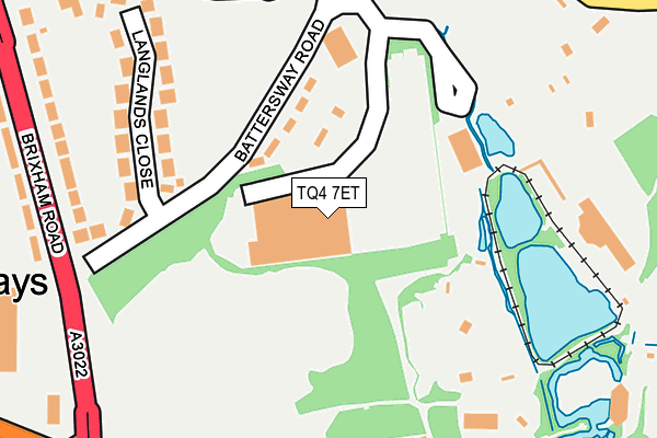
TQ4 7ET is located in the Goodrington with Roselands electoral ward, within the unitary authority of Torbay and the English Parliamentary constituency of Torbay. The Sub Integrated Care Board (ICB) Location is NHS Devon ICB - 15N and the police force is Devon & Cornwall. This postcode has been in use since January 1980.


GetTheData
Source: OS OpenMap – Local (Ordnance Survey)
Source: OS VectorMap District (Ordnance Survey)
Licence: Open Government Licence (requires attribution)
| Easting | 287556 |
| Northing | 59744 |
| Latitude | 50.426754 |
| Longitude | -3.584380 |
GetTheData
Source: Open Postcode Geo
Licence: Open Government Licence
| Country | England |
| Postcode District | TQ4 |
| ➜ TQ4 open data dashboard ➜ See where TQ4 is on a map ➜ Where is Paignton? | |
GetTheData
Source: Land Registry Price Paid Data
Licence: Open Government Licence
Elevation or altitude of TQ4 7ET as distance above sea level:
| Metres | Feet | |
|---|---|---|
| Elevation | 40m | 131ft |
Elevation is measured from the approximate centre of the postcode, to the nearest point on an OS contour line from OS Terrain 50, which has contour spacing of ten vertical metres.
➜ How high above sea level am I? Find the elevation of your current position using your device's GPS.
GetTheData
Source: Open Postcode Elevation
Licence: Open Government Licence
| Ward | Goodrington With Roselands |
| Constituency | Torbay |
GetTheData
Source: ONS Postcode Database
Licence: Open Government Licence
| June 2022 | Drugs | On or near Supermarket | 2m |
| June 2022 | Other theft | On or near Supermarket | 2m |
| June 2022 | Other theft | On or near Battersway Road | 100m |
| ➜ Get more crime data in our Crime section | |||
GetTheData
Source: data.police.uk
Licence: Open Government Licence
| Morrisons (Morrisons Super Store) | Paignton | 18m |
| Zoo (Totnes Road) | Paignton | 223m |
| Bookers (Brixham Road) | Paignton | 244m |
| Zoo (Totnes Road) | Paignton | 262m |
| Bookers (Brixham Road) | Paignton | 275m |
| Paignton (Paignton And Dartmouth Railway) (Great Western Road) | Paignton | 1,650m |
| Paignton Station | 1.6km |
| Torquay Station | 4.8km |
GetTheData
Source: NaPTAN
Licence: Open Government Licence
GetTheData
Source: ONS Postcode Database
Licence: Open Government Licence


➜ Get more ratings from the Food Standards Agency
GetTheData
Source: Food Standards Agency
Licence: FSA terms & conditions
| Last Collection | |||
|---|---|---|---|
| Location | Mon-Fri | Sat | Distance |
| Lulworth Close | 17:15 | 12:30 | 933m |
| Kings Ash Hill | 17:30 | 12:30 | 991m |
| Old Elm Park Post Office | 17:00 | 12:00 | 1,001m |
GetTheData
Source: Dracos
Licence: Creative Commons Attribution-ShareAlike
| Facility | Distance |
|---|---|
| Paignton Community & Sports Academy (Waterleat Road) Waterleat Road, Paignton Sports Hall, Artificial Grass Pitch, Grass Pitches | 389m |
| Hayes School Hayes Road, Paignton Grass Pitches | 541m |
| Paignton Community & Sports Academy (Borough Road) Borough Road, Paignton Sports Hall, Swimming Pool, Health and Fitness Gym, Grass Pitches, Studio | 576m |
GetTheData
Source: Active Places
Licence: Open Government Licence
| School | Phase of Education | Distance |
|---|---|---|
| Paignton Academy Waterleat Road, Paignton, TQ3 3WA | Secondary | 390m |
| Cambian Devon School Intek House, 52 Borough Road, Paignton, TQ4 7DQ | Not applicable | 525m |
| Hayes School Hayes Road, Paignton, TQ4 5PJ | Primary | 568m |
GetTheData
Source: Edubase
Licence: Open Government Licence
The below table lists the International Territorial Level (ITL) codes (formerly Nomenclature of Territorial Units for Statistics (NUTS) codes) and Local Administrative Units (LAU) codes for TQ4 7ET:
| ITL 1 Code | Name |
|---|---|
| TLK | South West (England) |
| ITL 2 Code | Name |
| TLK4 | Devon |
| ITL 3 Code | Name |
| TLK42 | Torbay |
| LAU 1 Code | Name |
| E06000027 | Torbay |
GetTheData
Source: ONS Postcode Directory
Licence: Open Government Licence
The below table lists the Census Output Area (OA), Lower Layer Super Output Area (LSOA), and Middle Layer Super Output Area (MSOA) for TQ4 7ET:
| Code | Name | |
|---|---|---|
| OA | E00076913 | |
| LSOA | E01015221 | Torbay 015C |
| MSOA | E02003168 | Torbay 015 |
GetTheData
Source: ONS Postcode Directory
Licence: Open Government Licence
| TQ4 7EX | Battersway Road | 92m |
| TQ4 7HA | Langlands Close | 213m |
| TQ4 7EZ | Battersway Road | 217m |
| TQ4 7HQ | Brixham Road | 262m |
| TQ4 7DU | Harbourne Avenue | 271m |
| TQ4 7HG | Brixham Road | 288m |
| TQ4 7EQ | Harbourne Avenue | 331m |
| TQ4 7HL | Longstone Road | 335m |
| TQ4 7HB | Totnes Road | 338m |
| TQ4 7DW | Brixham Road | 350m |
GetTheData
Source: Open Postcode Geo; Land Registry Price Paid Data
Licence: Open Government Licence