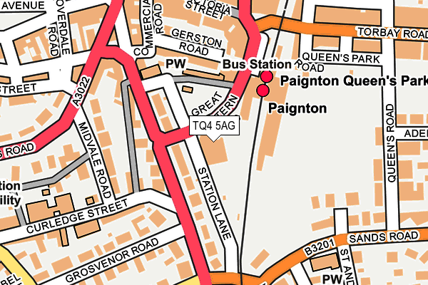
TQ4 5AG is located in the Roundham with Hyde electoral ward, within the unitary authority of Torbay and the English Parliamentary constituency of Torbay. The Sub Integrated Care Board (ICB) Location is NHS Devon ICB - 15N and the police force is Devon & Cornwall. This postcode has been in use since July 2010.


GetTheData
Source: OS OpenMap – Local (Ordnance Survey)
Source: OS VectorMap District (Ordnance Survey)
Licence: Open Government Licence (requires attribution)
| Easting | 288886 |
| Northing | 60504 |
| Latitude | 50.433840 |
| Longitude | -3.565889 |
GetTheData
Source: Open Postcode Geo
Licence: Open Government Licence
| Country | England |
| Postcode District | TQ4 |
| ➜ TQ4 open data dashboard ➜ See where TQ4 is on a map ➜ Where is Paignton? | |
GetTheData
Source: Land Registry Price Paid Data
Licence: Open Government Licence
Elevation or altitude of TQ4 5AG as distance above sea level:
| Metres | Feet | |
|---|---|---|
| Elevation | 10m | 33ft |
Elevation is measured from the approximate centre of the postcode, to the nearest point on an OS contour line from OS Terrain 50, which has contour spacing of ten vertical metres.
➜ How high above sea level am I? Find the elevation of your current position using your device's GPS.
GetTheData
Source: Open Postcode Elevation
Licence: Open Government Licence
| Ward | Roundham With Hyde |
| Constituency | Torbay |
GetTheData
Source: ONS Postcode Database
Licence: Open Government Licence
| October 2022 | Anti-social behaviour | On or near Littlegate Road | 494m |
| October 2022 | Anti-social behaviour | On or near Littlegate Road | 494m |
| October 2022 | Public order | On or near Littlegate Road | 494m |
| ➜ Get more crime data in our Crime section | |||
GetTheData
Source: data.police.uk
Licence: Open Government Licence
| Great Western Road | Paignton | 34m |
| Dartmouth Road | Paignton | 146m |
| Midvale Road | Paignton | 167m |
| Dart Valley Railway (Torbay Road) | Paignton | 213m |
| Palace Avenue (Totnes Road) | Paignton | 234m |
| Paignton (Paignton And Dartmouth Railway) (Great Western Road) | Paignton | 124m |
| Goodrington (Paignton And Dartmouth Railway) (Tanners Road) | Paignton | 978m |
| Paignton Station | 0.1km |
| Torquay Station | 3.4km |
| Torre Station | 4.6km |
GetTheData
Source: NaPTAN
Licence: Open Government Licence
GetTheData
Source: ONS Postcode Database
Licence: Open Government Licence


➜ Get more ratings from the Food Standards Agency
GetTheData
Source: Food Standards Agency
Licence: FSA terms & conditions
| Last Collection | |||
|---|---|---|---|
| Location | Mon-Fri | Sat | Distance |
| Station Square | 17:30 | 12:00 | 191m |
| Paignton Post Office | 19:00 | 13:00 | 328m |
| Palace Avenue | 17:30 | 12:45 | 355m |
GetTheData
Source: Dracos
Licence: Creative Commons Attribution-ShareAlike
| Facility | Distance |
|---|---|
| Winners 2000 Fitness Limited (Paignton) (Closed) Dartmouth Road, Paignton Health and Fitness Gym | 203m |
| Queens Park Sports Club Queens Road, Paignton Grass Pitches | 233m |
| Tower House School (Closed) Fisher Street, Paignton Sports Hall | 407m |
GetTheData
Source: Active Places
Licence: Open Government Licence
| School | Phase of Education | Distance |
|---|---|---|
| Curledge Street Academy Curledge Street, Paignton, TQ4 5BA | Primary | 214m |
| St Michael's Church of England Academy Fisher Street, Paignton, TQ4 5EW | Primary | 431m |
| Sacred Heart Catholic School Cecil Road, Paignton, TQ3 2SH | Primary | 704m |
GetTheData
Source: Edubase
Licence: Open Government Licence
The below table lists the International Territorial Level (ITL) codes (formerly Nomenclature of Territorial Units for Statistics (NUTS) codes) and Local Administrative Units (LAU) codes for TQ4 5AG:
| ITL 1 Code | Name |
|---|---|
| TLK | South West (England) |
| ITL 2 Code | Name |
| TLK4 | Devon |
| ITL 3 Code | Name |
| TLK42 | Torbay |
| LAU 1 Code | Name |
| E06000027 | Torbay |
GetTheData
Source: ONS Postcode Directory
Licence: Open Government Licence
The below table lists the Census Output Area (OA), Lower Layer Super Output Area (LSOA), and Middle Layer Super Output Area (MSOA) for TQ4 5AG:
| Code | Name | |
|---|---|---|
| OA | E00076989 | |
| LSOA | E01015232 | Torbay 014C |
| MSOA | E02003167 | Torbay 014 |
GetTheData
Source: ONS Postcode Directory
Licence: Open Government Licence
| TQ4 5AR | Station Lane | 54m |
| TQ4 5AE | Dartmouth Road | 79m |
| TQ4 5AD | Dartmouth Road | 86m |
| TQ4 5DY | Gerston Road | 110m |
| TQ4 5AQ | Dartmouth Road | 119m |
| TQ4 5AJ | Dartmouth Road | 134m |
| TQ4 5EA | Gerston Road | 150m |
| TQ4 5BD | Midvale Road | 154m |
| TQ4 5AL | Dartmouth Road | 158m |
| TQ4 5DS | Victoria Street | 160m |
GetTheData
Source: Open Postcode Geo; Land Registry Price Paid Data
Licence: Open Government Licence