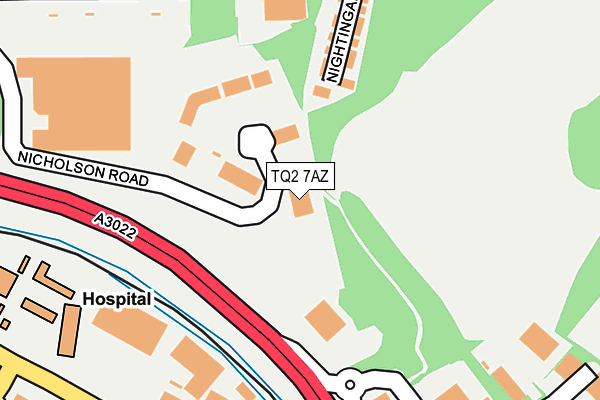
TQ2 7AZ is located in the Barton with Watcombe electoral ward, within the unitary authority of Torbay and the English Parliamentary constituency of Torbay. The Sub Integrated Care Board (ICB) Location is NHS Devon ICB - 15N and the police force is Devon & Cornwall. This postcode has been in use since December 1995.


GetTheData
Source: OS OpenMap – Local (Ordnance Survey)
Source: OS VectorMap District (Ordnance Survey)
Licence: Open Government Licence (requires attribution)
| Easting | 290008 |
| Northing | 66368 |
| Latitude | 50.486767 |
| Longitude | -3.551821 |
GetTheData
Source: Open Postcode Geo
Licence: Open Government Licence
| Country | England |
| Postcode District | TQ2 |
| ➜ TQ2 open data dashboard ➜ See where TQ2 is on a map | |
GetTheData
Source: Land Registry Price Paid Data
Licence: Open Government Licence
Elevation or altitude of TQ2 7AZ as distance above sea level:
| Metres | Feet | |
|---|---|---|
| Elevation | 70m | 230ft |
Elevation is measured from the approximate centre of the postcode, to the nearest point on an OS contour line from OS Terrain 50, which has contour spacing of ten vertical metres.
➜ How high above sea level am I? Find the elevation of your current position using your device's GPS.
GetTheData
Source: Open Postcode Elevation
Licence: Open Government Licence
| Ward | Barton With Watcombe |
| Constituency | Torbay |
GetTheData
Source: ONS Postcode Database
Licence: Open Government Licence
| September 2022 | Anti-social behaviour | On or near Nicholson Road | 306m |
| August 2022 | Criminal damage and arson | On or near Nicholson Road | 306m |
| June 2022 | Shoplifting | On or near Petrol Station | 236m |
| ➜ Get more crime data in our Crime section | |||
GetTheData
Source: data.police.uk
Licence: Open Government Licence
| Cadewell Lane (Newton Road) | Shiphay | 294m |
| Cadewell Lane (Newton Road) | Shiphay | 301m |
| Newton Road | Shiphay | 348m |
| Nightingale Close (Browns Bridge Road) | The Willows | 355m |
| Wren Park (Browns Bridge Road) | The Willows | 361m |
| Torre Station | 1.6km |
| Torquay Station | 2.9km |
| Newton Abbot Station | 5.8km |
GetTheData
Source: NaPTAN
Licence: Open Government Licence
GetTheData
Source: ONS Postcode Database
Licence: Open Government Licence


➜ Get more ratings from the Food Standards Agency
GetTheData
Source: Food Standards Agency
Licence: FSA terms & conditions
| Last Collection | |||
|---|---|---|---|
| Location | Mon-Fri | Sat | Distance |
| Royal Mail | 19:15 | 13:30 | 296m |
| Lowes Bridge Post Office | 18:00 | 12:00 | 346m |
| Cassiobury Way | 17:45 | 13:15 | 578m |
GetTheData
Source: Dracos
Licence: Creative Commons Attribution-ShareAlike
| Facility | Distance |
|---|---|
| Puregym (Torquay Bridge Retail Park) Bridge Retail Park, Hele Road, Torquay Health and Fitness Gym | 476m |
| Evolve Health And Fitness Woodland Close, Torquay Health and Fitness Gym, Studio | 641m |
| Torquay Alpine Ski Club Kingskerswell Road, Torquay Ski Slopes | 702m |
GetTheData
Source: Active Places
Licence: Open Government Licence
| School | Phase of Education | Distance |
|---|---|---|
| The Lodestar Academy South Parks Road, Torquay, TQ2 8JE | Not applicable | 595m |
| Barton Hill Academy Barton Hill Road, Torquay, TQ2 8JA | Primary | 860m |
| Torquay Academy Cricketfield Road, Torquay, TQ2 7NU | Secondary | 1km |
GetTheData
Source: Edubase
Licence: Open Government Licence
The below table lists the International Territorial Level (ITL) codes (formerly Nomenclature of Territorial Units for Statistics (NUTS) codes) and Local Administrative Units (LAU) codes for TQ2 7AZ:
| ITL 1 Code | Name |
|---|---|
| TLK | South West (England) |
| ITL 2 Code | Name |
| TLK4 | Devon |
| ITL 3 Code | Name |
| TLK42 | Torbay |
| LAU 1 Code | Name |
| E06000027 | Torbay |
GetTheData
Source: ONS Postcode Directory
Licence: Open Government Licence
The below table lists the Census Output Area (OA), Lower Layer Super Output Area (LSOA), and Middle Layer Super Output Area (MSOA) for TQ2 7AZ:
| Code | Name | |
|---|---|---|
| OA | E00077062 | |
| LSOA | E01015253 | Torbay 003E |
| MSOA | E02003156 | Torbay 003 |
GetTheData
Source: ONS Postcode Directory
Licence: Open Government Licence
| TQ2 7ST | Nightingale Close | 226m |
| TQ2 7AJ | Newton Road | 299m |
| TQ2 7AD | Newton Road | 323m |
| TQ2 7AF | Littlefield Close | 374m |
| TQ2 7AB | Newton Road | 387m |
| TQ2 7AE | Cadewell Crescent | 400m |
| TQ2 7GG | Nightjar Close | 406m |
| TQ2 7GF | Nuthatch Drive | 407m |
| TQ2 7AQ | Newton Road | 435m |
| TQ2 7AH | Newton Road | 436m |
GetTheData
Source: Open Postcode Geo; Land Registry Price Paid Data
Licence: Open Government Licence