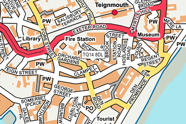
TQ14 8DL is located in the Teignmouth Central electoral ward, within the local authority district of Teignbridge and the English Parliamentary constituency of Newton Abbot. The Sub Integrated Care Board (ICB) Location is NHS Devon ICB - 15N and the police force is Devon & Cornwall. This postcode has been in use since January 1980.


GetTheData
Source: OS OpenMap – Local (Ordnance Survey)
Source: OS VectorMap District (Ordnance Survey)
Licence: Open Government Licence (requires attribution)
| Easting | 294129 |
| Northing | 72959 |
| Latitude | 50.546780 |
| Longitude | -3.495624 |
GetTheData
Source: Open Postcode Geo
Licence: Open Government Licence
| Country | England |
| Postcode District | TQ14 |
| ➜ TQ14 open data dashboard ➜ See where TQ14 is on a map ➜ Where is Teignmouth? | |
GetTheData
Source: Land Registry Price Paid Data
Licence: Open Government Licence
Elevation or altitude of TQ14 8DL as distance above sea level:
| Metres | Feet | |
|---|---|---|
| Elevation | 10m | 33ft |
Elevation is measured from the approximate centre of the postcode, to the nearest point on an OS contour line from OS Terrain 50, which has contour spacing of ten vertical metres.
➜ How high above sea level am I? Find the elevation of your current position using your device's GPS.
GetTheData
Source: Open Postcode Elevation
Licence: Open Government Licence
| Ward | Teignmouth Central |
| Constituency | Newton Abbot |
GetTheData
Source: ONS Postcode Database
Licence: Open Government Licence
| October 2022 | Other crime | On or near Exeter Street | 336m |
| September 2022 | Anti-social behaviour | On or near Mere Lane | 276m |
| June 2022 | Public order | On or near Police Station | 37m |
| ➜ Get more crime data in our Crime section | |||
GetTheData
Source: data.police.uk
Licence: Open Government Licence
| W H Smith (Wellington Street) | Teignmouth | 53m |
| Orchard Gardens | Teignmouth | 74m |
| Orchard Gardens | Teignmouth | 78m |
| Post Office (Den Road) | Teignmouth | 132m |
| Seaview Diner (Esplanade) | Teignmouth | 142m |
| Teignmouth Station | 0.2km |
| Dawlish Station | 4.4km |
GetTheData
Source: NaPTAN
Licence: Open Government Licence
GetTheData
Source: ONS Postcode Database
Licence: Open Government Licence


➜ Get more ratings from the Food Standards Agency
GetTheData
Source: Food Standards Agency
Licence: FSA terms & conditions
| Last Collection | |||
|---|---|---|---|
| Location | Mon-Fri | Sat | Distance |
| Teignmouth Delivery Office | 18:30 | 13:30 | 123m |
| Railway Station | 17:15 | 12:45 | 178m |
| Den Promenade | 17:30 | 12:45 | 179m |
GetTheData
Source: Dracos
Licence: Creative Commons Attribution-ShareAlike
| Facility | Distance |
|---|---|
| Teignmouth Lido Eastcliff Walk, Teignmouth Swimming Pool | 371m |
| Teignmouth Community School Exeter Road, Teignmouth Grass Pitches, Sports Hall, Artificial Grass Pitch, Studio, Health and Fitness Gym | 462m |
| Bitton Park Bitton Park Road, Teignmouth Grass Pitches | 800m |
GetTheData
Source: Active Places
Licence: Open Government Licence
| School | Phase of Education | Distance |
|---|---|---|
| Teignmouth Community School, Exeter Road Exeter Road, Teignmouth, TQ14 9HZ | Secondary | 784m |
| Trinity School Buckeridge Road, Teignmouth, Devon, TQ14 8LY | Not applicable | 1.1km |
| Shaldon Primary School Bridge Road, Shaldon, Teignmouth, TQ14 0DD | Primary | 1.2km |
GetTheData
Source: Edubase
Licence: Open Government Licence
The below table lists the International Territorial Level (ITL) codes (formerly Nomenclature of Territorial Units for Statistics (NUTS) codes) and Local Administrative Units (LAU) codes for TQ14 8DL:
| ITL 1 Code | Name |
|---|---|
| TLK | South West (England) |
| ITL 2 Code | Name |
| TLK4 | Devon |
| ITL 3 Code | Name |
| TLK43 | Devon CC |
| LAU 1 Code | Name |
| E07000045 | Teignbridge |
GetTheData
Source: ONS Postcode Directory
Licence: Open Government Licence
The below table lists the Census Output Area (OA), Lower Layer Super Output Area (LSOA), and Middle Layer Super Output Area (MSOA) for TQ14 8DL:
| Code | Name | |
|---|---|---|
| OA | E00102657 | |
| LSOA | E01020269 | Teignbridge 010B |
| MSOA | E02004210 | Teignbridge 010 |
GetTheData
Source: ONS Postcode Directory
Licence: Open Government Licence
| TQ14 8DS | Orchard Gardens | 15m |
| TQ14 8HT | Bickford Lane | 26m |
| TQ14 8HW | Wellington Street | 33m |
| TQ14 8HR | Lower Brook Street | 50m |
| TQ14 8SW | Regent Street | 58m |
| TQ14 8DP | Orchard Gardens | 61m |
| TQ14 8DN | Clampet Lane | 64m |
| TQ14 8HH | Wellington Street | 65m |
| TQ14 8DJ | Orchard Gardens | 66m |
| TQ14 8GB | Clampet Lane | 72m |
GetTheData
Source: Open Postcode Geo; Land Registry Price Paid Data
Licence: Open Government Licence