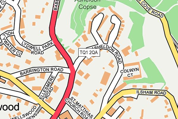
TQ1 2QA lies on Brompton Gardens in Torquay. TQ1 2QA is located in the Wellswood electoral ward, within the unitary authority of Torbay and the English Parliamentary constituency of Torbay. The Sub Integrated Care Board (ICB) Location is NHS Devon ICB - 15N and the police force is Devon & Cornwall. This postcode has been in use since July 2002.


GetTheData
Source: OS OpenMap – Local (Ordnance Survey)
Source: OS VectorMap District (Ordnance Survey)
Licence: Open Government Licence (requires attribution)
| Easting | 293270 |
| Northing | 64363 |
| Latitude | 50.469347 |
| Longitude | -3.505284 |
GetTheData
Source: Open Postcode Geo
Licence: Open Government Licence
| Street | Brompton Gardens |
| Town/City | Torquay |
| Country | England |
| Postcode District | TQ1 |
| ➜ TQ1 open data dashboard ➜ See where TQ1 is on a map ➜ Where is Torquay? | |
GetTheData
Source: Land Registry Price Paid Data
Licence: Open Government Licence
Elevation or altitude of TQ1 2QA as distance above sea level:
| Metres | Feet | |
|---|---|---|
| Elevation | 70m | 230ft |
Elevation is measured from the approximate centre of the postcode, to the nearest point on an OS contour line from OS Terrain 50, which has contour spacing of ten vertical metres.
➜ How high above sea level am I? Find the elevation of your current position using your device's GPS.
GetTheData
Source: Open Postcode Elevation
Licence: Open Government Licence
| Ward | Wellswood |
| Constituency | Torbay |
GetTheData
Source: ONS Postcode Database
Licence: Open Government Licence
| August 2022 | Public order | On or near St Matthias Church Road | 176m |
| July 2022 | Criminal damage and arson | On or near Ansteys Close | 126m |
| June 2022 | Violence and sexual offences | On or near Asheldon Road | 122m |
| ➜ Get more crime data in our Crime section | |||
GetTheData
Source: data.police.uk
Licence: Open Government Licence
| Lydwell Park Road (Babbacombe Road) | Wellswood | 78m |
| Asheldon Road | Wellswood | 84m |
| Ansteys Close (Asheldon Road) | Wellswood | 91m |
| Ilsham House (Asheldon Road) | Wellswood | 152m |
| Asheldon Road | Wellswood | 158m |
| Torquay Station | 2.8km |
| Torre Station | 3km |
| Paignton Station | 5.7km |
GetTheData
Source: NaPTAN
Licence: Open Government Licence
| Percentage of properties with Next Generation Access | 100.0% |
| Percentage of properties with Superfast Broadband | 100.0% |
| Percentage of properties with Ultrafast Broadband | 100.0% |
| Percentage of properties with Full Fibre Broadband | 100.0% |
Superfast Broadband is between 30Mbps and 300Mbps
Ultrafast Broadband is > 300Mbps
| Percentage of properties unable to receive 2Mbps | 0.0% |
| Percentage of properties unable to receive 5Mbps | 0.0% |
| Percentage of properties unable to receive 10Mbps | 0.0% |
| Percentage of properties unable to receive 30Mbps | 0.0% |
GetTheData
Source: Ofcom
Licence: Ofcom Terms of Use (requires attribution)
GetTheData
Source: ONS Postcode Database
Licence: Open Government Licence


➜ Get more ratings from the Food Standards Agency
GetTheData
Source: Food Standards Agency
Licence: FSA terms & conditions
| Last Collection | |||
|---|---|---|---|
| Location | Mon-Fri | Sat | Distance |
| Wellswood Place Post Office | 18:00 | 12:15 | 273m |
| Oxlea Road | 17:15 | 12:30 | 645m |
| Lincombe Drive | 17:15 | 12:30 | 767m |
GetTheData
Source: Dracos
Licence: Creative Commons Attribution-ShareAlike
| Facility | Distance |
|---|---|
| Stoodley Knowle Playing Fields (Closed) Ilsham Close, Torquay Grass Pitches | 284m |
| Palace Hotel (Closed) Babbacombe Road, Torquay Indoor Tennis Centre, Health and Fitness Gym, Swimming Pool, Golf, Squash Courts, Outdoor Tennis Courts | 329m |
| Stoodley Knowle School (Closed) Ansteys Cove Road, Torquay Sports Hall, Swimming Pool | 420m |
GetTheData
Source: Active Places
Licence: Open Government Licence
| School | Phase of Education | Distance |
|---|---|---|
| Ilsham Church of England Academy Ilsham Road, Torquay, TQ1 2JQ | Primary | 265m |
| Warberry CofE Academy Cedars Road, Torquay, TQ1 1SB | Primary | 855m |
| All Saints Babbacombe CofE Primary School Quinta Road, Torquay, TQ1 3RN | Primary | 879m |
GetTheData
Source: Edubase
Licence: Open Government Licence
The below table lists the International Territorial Level (ITL) codes (formerly Nomenclature of Territorial Units for Statistics (NUTS) codes) and Local Administrative Units (LAU) codes for TQ1 2QA:
| ITL 1 Code | Name |
|---|---|
| TLK | South West (England) |
| ITL 2 Code | Name |
| TLK4 | Devon |
| ITL 3 Code | Name |
| TLK42 | Torbay |
| LAU 1 Code | Name |
| E06000027 | Torbay |
GetTheData
Source: ONS Postcode Directory
Licence: Open Government Licence
The below table lists the Census Output Area (OA), Lower Layer Super Output Area (LSOA), and Middle Layer Super Output Area (MSOA) for TQ1 2QA:
| Code | Name | |
|---|---|---|
| OA | E00077177 | |
| LSOA | E01015269 | Torbay 010C |
| MSOA | E02003163 | Torbay 010 |
GetTheData
Source: ONS Postcode Directory
Licence: Open Government Licence
| TQ1 2QN | Asheldon Road | 10m |
| TQ1 2QR | Asheldon Road | 67m |
| TQ1 2QS | Asheldon Road | 83m |
| TQ1 2QL | Babbacombe Road | 87m |
| TQ1 2QW | Thorncliff Close | 124m |
| TQ1 2QP | Ansteys Close | 134m |
| TQ1 2QU | Asheldon Road | 145m |
| TQ1 2QJ | Barrington Road | 159m |
| TQ1 2JH | St Matthias Church Road | 159m |
| TQ1 2QT | Asheldon Road | 162m |
GetTheData
Source: Open Postcode Geo; Land Registry Price Paid Data
Licence: Open Government Licence