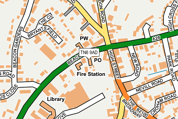
TN6 9AD is located in the Crowborough Central electoral ward, within the local authority district of Wealden and the English Parliamentary constituency of Wealden. The Sub Integrated Care Board (ICB) Location is NHS Sussex ICB - 97R and the police force is Sussex. This postcode has been in use since August 2012.


GetTheData
Source: OS OpenMap – Local (Ordnance Survey)
Source: OS VectorMap District (Ordnance Survey)
Licence: Open Government Licence (requires attribution)
| Easting | 551513 |
| Northing | 131207 |
| Latitude | 51.060216 |
| Longitude | 0.160707 |
GetTheData
Source: Open Postcode Geo
Licence: Open Government Licence
| Country | England |
| Postcode District | TN6 |
| ➜ TN6 open data dashboard ➜ See where TN6 is on a map ➜ Where is Crowborough? | |
GetTheData
Source: Land Registry Price Paid Data
Licence: Open Government Licence
Elevation or altitude of TN6 9AD as distance above sea level:
| Metres | Feet | |
|---|---|---|
| Elevation | 210m | 689ft |
Elevation is measured from the approximate centre of the postcode, to the nearest point on an OS contour line from OS Terrain 50, which has contour spacing of ten vertical metres.
➜ How high above sea level am I? Find the elevation of your current position using your device's GPS.
GetTheData
Source: Open Postcode Elevation
Licence: Open Government Licence
| Ward | Crowborough Central |
| Constituency | Wealden |
GetTheData
Source: ONS Postcode Database
Licence: Open Government Licence
| January 2024 | Other theft | On or near Petrol Station | 95m |
| January 2024 | Anti-social behaviour | On or near Petrol Station | 95m |
| January 2024 | Other theft | On or near Petrol Station | 95m |
| ➜ Get more crime data in our Crime section | |||
GetTheData
Source: data.police.uk
Licence: Open Government Licence
| The Cross (Eridge Road) | Crowborough | 111m |
| Broadway (High Street) | Crowborough | 137m |
| Broadway (High Street) | Crowborough | 154m |
| The Cross (Eridge Road) | Crowborough | 164m |
| Waitrose (Croft Road) | Crowborough | 248m |
| Crowborough Station | 2.5km |
| Eridge Station | 4.3km |
GetTheData
Source: NaPTAN
Licence: Open Government Licence
GetTheData
Source: ONS Postcode Database
Licence: Open Government Licence


➜ Get more ratings from the Food Standards Agency
GetTheData
Source: Food Standards Agency
Licence: FSA terms & conditions
| Last Collection | |||
|---|---|---|---|
| Location | Mon-Fri | Sat | Distance |
| Crowborough Sorting Office | 18:00 | 12:45 | 89m |
| Broadway | 17:45 | 12:00 | 139m |
| Crowborough Post Office | 17:15 | 12:30 | 231m |
GetTheData
Source: Dracos
Licence: Creative Commons Attribution-ShareAlike
| Facility | Distance |
|---|---|
| Goldsmiths Recreation Ground Eridge Road, Crowborough Athletics, Grass Pitches, Outdoor Tennis Courts | 523m |
| Crowborough Leisure Centre Eridge Road, Crowborough Sports Hall, Swimming Pool, Health and Fitness Gym, Studio | 534m |
| Crowborough Tennis And Squash Club Ltd Church Road, Crowborough Squash Courts, Outdoor Tennis Courts, Studio | 647m |
GetTheData
Source: Active Places
Licence: Open Government Licence
| School | Phase of Education | Distance |
|---|---|---|
| St Marys Catholic Primary School Chapel Green, Crowborough, TN6 2LB | Primary | 852m |
| Sir Henry Fermor Church of England Primary School Crowborough Hill, Crowborough, TN6 2SD | Primary | 888m |
| Grove Park School Church Road, Crowborough, TN6 1BN | Not applicable | 923m |
GetTheData
Source: Edubase
Licence: Open Government Licence
The below table lists the International Territorial Level (ITL) codes (formerly Nomenclature of Territorial Units for Statistics (NUTS) codes) and Local Administrative Units (LAU) codes for TN6 9AD:
| ITL 1 Code | Name |
|---|---|
| TLJ | South East (England) |
| ITL 2 Code | Name |
| TLJ2 | Surrey, East and West Sussex |
| ITL 3 Code | Name |
| TLJ22 | East Sussex CC |
| LAU 1 Code | Name |
| E07000065 | Wealden |
GetTheData
Source: ONS Postcode Directory
Licence: Open Government Licence
The below table lists the Census Output Area (OA), Lower Layer Super Output Area (LSOA), and Middle Layer Super Output Area (MSOA) for TN6 9AD:
| Code | Name | |
|---|---|---|
| OA | E00107504 | |
| LSOA | E01021160 | Wealden 004B |
| MSOA | E02004406 | Wealden 004 |
GetTheData
Source: ONS Postcode Directory
Licence: Open Government Licence
| TN6 1AF | Beacon Road | 21m |
| TN6 1AS | Beacon Road | 62m |
| TN6 2QB | High Street | 76m |
| TN6 2FX | Eridge Road | 88m |
| TN6 2QA | High Street | 96m |
| TN6 2SJ | Eridge Road | 105m |
| TN6 2TT | London Road | 117m |
| TN6 2FT | New Road | 131m |
| TN6 2QD | New Road | 137m |
| TN6 2SH | Eridge Road | 142m |
GetTheData
Source: Open Postcode Geo; Land Registry Price Paid Data
Licence: Open Government Licence