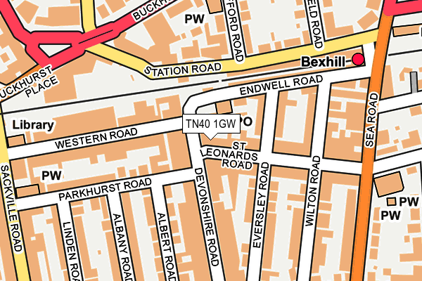
TN40 1GW is located in the Bexhill Central electoral ward, within the local authority district of Rother and the English Parliamentary constituency of Bexhill and Battle. The Sub Integrated Care Board (ICB) Location is NHS Sussex ICB - 97R and the police force is Sussex. This postcode has been in use since June 1998.


GetTheData
Source: OS OpenMap – Local (Ordnance Survey)
Source: OS VectorMap District (Ordnance Survey)
Licence: Open Government Licence (requires attribution)
| Easting | 574280 |
| Northing | 107421 |
| Latitude | 50.840072 |
| Longitude | 0.473911 |
GetTheData
Source: Open Postcode Geo
Licence: Open Government Licence
| Country | England |
| Postcode District | TN40 |
| ➜ TN40 open data dashboard ➜ See where TN40 is on a map ➜ Where is Bexhill? | |
GetTheData
Source: Land Registry Price Paid Data
Licence: Open Government Licence
Elevation or altitude of TN40 1GW as distance above sea level:
| Metres | Feet | |
|---|---|---|
| Elevation | 10m | 33ft |
Elevation is measured from the approximate centre of the postcode, to the nearest point on an OS contour line from OS Terrain 50, which has contour spacing of ten vertical metres.
➜ How high above sea level am I? Find the elevation of your current position using your device's GPS.
GetTheData
Source: Open Postcode Elevation
Licence: Open Government Licence
| Ward | Bexhill Central |
| Constituency | Bexhill And Battle |
GetTheData
Source: ONS Postcode Database
Licence: Open Government Licence
| January 2024 | Possession of weapons | On or near Supermarket | 229m |
| December 2023 | Anti-social behaviour | On or near Supermarket | 229m |
| December 2023 | Other theft | On or near Supermarket | 229m |
| ➜ Get more crime data in our Crime section | |||
GetTheData
Source: data.police.uk
Licence: Open Government Licence
| Eversley Road (Endwell Road) | Bexhill | 75m |
| The Harp (Devonshire Road) | Bexhill | 116m |
| The Harp (Devonshire Road) | Bexhill | 118m |
| Railway Station (Endwell Road) | Bexhill | 226m |
| Cantelupe Road (Sea Road) | Bexhill | 235m |
| Bexhill Station | 0.2km |
| Collington Station | 1.1km |
| Cooden Beach Station | 3.4km |
GetTheData
Source: NaPTAN
Licence: Open Government Licence
GetTheData
Source: ONS Postcode Database
Licence: Open Government Licence


➜ Get more ratings from the Food Standards Agency
GetTheData
Source: Food Standards Agency
Licence: FSA terms & conditions
| Last Collection | |||
|---|---|---|---|
| Location | Mon-Fri | Sat | Distance |
| Bexhill Sorting Office | 18:45 | 13:00 | 47m |
| St Leonards Road | 18:30 | 12:45 | 207m |
| Endwell Road | 18:30 | 12:30 | 217m |
GetTheData
Source: Dracos
Licence: Creative Commons Attribution-ShareAlike
| Facility | Distance |
|---|---|
| Bexhill Youth And Community Centre Station Road, Bexhill-on-sea Sports Hall | 132m |
| Tl Health Club (Closed) Western Road, Bexhill-on-sea Health and Fitness Gym, Studio | 173m |
| Gullivers Bowls Club Knole Road, Bexhill-on-sea Indoor Bowls | 393m |
GetTheData
Source: Active Places
Licence: Open Government Licence
| School | Phase of Education | Distance |
|---|---|---|
| St Peter and St Paul CofE Primary School Buckhurst Road, Bexhill-on-Sea, TN40 1QE | Primary | 437m |
| Chantry Community Primary School Barrack Road, Bexhill-on-Sea, TN40 2AT | Primary | 828m |
| The Workplace Down Road, Bexhill-on-Sea, TN39 4HS | Not applicable | 883m |
GetTheData
Source: Edubase
Licence: Open Government Licence
The below table lists the International Territorial Level (ITL) codes (formerly Nomenclature of Territorial Units for Statistics (NUTS) codes) and Local Administrative Units (LAU) codes for TN40 1GW:
| ITL 1 Code | Name |
|---|---|
| TLJ | South East (England) |
| ITL 2 Code | Name |
| TLJ2 | Surrey, East and West Sussex |
| ITL 3 Code | Name |
| TLJ22 | East Sussex CC |
| LAU 1 Code | Name |
| E07000064 | Rother |
GetTheData
Source: ONS Postcode Directory
Licence: Open Government Licence
The below table lists the Census Output Area (OA), Lower Layer Super Output Area (LSOA), and Middle Layer Super Output Area (MSOA) for TN40 1GW:
| Code | Name | |
|---|---|---|
| OA | E00107119 | |
| LSOA | E01021092 | Rother 011C |
| MSOA | E02004402 | Rother 011 |
GetTheData
Source: ONS Postcode Directory
Licence: Open Government Licence
| TN40 1HH | St Leonards Road | 31m |
| TN40 1AH | Devonshire Road | 33m |
| TN40 1HN | St Leonards Road | 59m |
| TN40 1AB | Devonshire Square | 62m |
| TN40 1EU | Eversley Road | 66m |
| TN40 1DH | Parkhurst Mews | 75m |
| TN40 1AS | Devonshire Road | 75m |
| TN40 1GR | Western Mews | 91m |
| TN40 1DU | Western Road | 107m |
| TN40 1DF | Parkhurst Road | 107m |
GetTheData
Source: Open Postcode Geo; Land Registry Price Paid Data
Licence: Open Government Licence