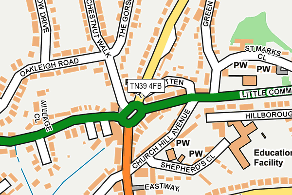
TN39 4FB is located in the Bexhill St Marks electoral ward, within the local authority district of Rother and the English Parliamentary constituency of Bexhill and Battle. The Sub Integrated Care Board (ICB) Location is NHS Sussex ICB - 97R and the police force is Sussex. This postcode has been in use since October 2012.


GetTheData
Source: OS OpenMap – Local (Ordnance Survey)
Source: OS VectorMap District (Ordnance Survey)
Licence: Open Government Licence (requires attribution)
| Easting | 571464 |
| Northing | 107928 |
| Latitude | 50.845468 |
| Longitude | 0.434192 |
GetTheData
Source: Open Postcode Geo
Licence: Open Government Licence
| Country | England |
| Postcode District | TN39 |
| ➜ TN39 open data dashboard ➜ See where TN39 is on a map ➜ Where is Bexhill? | |
GetTheData
Source: Land Registry Price Paid Data
Licence: Open Government Licence
Elevation or altitude of TN39 4FB as distance above sea level:
| Metres | Feet | |
|---|---|---|
| Elevation | 20m | 66ft |
Elevation is measured from the approximate centre of the postcode, to the nearest point on an OS contour line from OS Terrain 50, which has contour spacing of ten vertical metres.
➜ How high above sea level am I? Find the elevation of your current position using your device's GPS.
GetTheData
Source: Open Postcode Elevation
Licence: Open Government Licence
| Ward | Bexhill St Marks |
| Constituency | Bexhill And Battle |
GetTheData
Source: ONS Postcode Database
Licence: Open Government Licence
| December 2023 | Other theft | On or near Parking Area | 212m |
| December 2023 | Burglary | On or near Mansell Close | 408m |
| December 2023 | Violence and sexual offences | On or near Robin Hill | 450m |
| ➜ Get more crime data in our Crime section | |||
GetTheData
Source: data.police.uk
Licence: Open Government Licence
| Wheatsheaf (Barnhorn Road Roundabout) | Little Common | 41m |
| Wheatsheaf (Little Common Road) | Little Common | 54m |
| St Martha's Church (Cooden Sea Road) | Little Common | 225m |
| St Martha's Church (Cooden Sea Road) | Little Common | 244m |
| Howards Crescent (Barnhorn Road) | Little Common | 364m |
| Cooden Beach Station | 1.4km |
| Collington Station | 1.8km |
| Bexhill Station | 3.1km |
GetTheData
Source: NaPTAN
Licence: Open Government Licence
GetTheData
Source: ONS Postcode Database
Licence: Open Government Licence


➜ Get more ratings from the Food Standards Agency
GetTheData
Source: Food Standards Agency
Licence: FSA terms & conditions
| Last Collection | |||
|---|---|---|---|
| Location | Mon-Fri | Sat | Distance |
| Little Common Post Office | 17:00 | 12:00 | 20m |
| Churchill Avenue | 17:30 | 12:15 | 229m |
| The Byeway | 17:00 | 12:00 | 443m |
GetTheData
Source: Dracos
Licence: Creative Commons Attribution-ShareAlike
| Facility | Distance |
|---|---|
| Little Common School Shepherds Close, Bexhill-on-sea Grass Pitches, Swimming Pool | 186m |
| Little Common Recreation Ground Green Lane, Bexhill Grass Pitches, Outdoor Tennis Courts | 461m |
| Cooden Beach Sports And Social Club Withyham Road, Cooden, Bexhill-on-sea Squash Courts, Outdoor Tennis Courts, Sports Hall | 986m |
GetTheData
Source: Active Places
Licence: Open Government Licence
| School | Phase of Education | Distance |
|---|---|---|
| Little Common School Shepherds Close, Little Common Primary School, Bexhill-on-Sea, TN39 4SQ | Primary | 186m |
| Bexhill High Academy Gunters Lane, Bexhill-on-Sea, TN39 4BY | Secondary | 1.8km |
| Glenleigh Park Primary Academy Gunters Lane, Bexhill-on-Sea, TN39 4ED | Primary | 2km |
GetTheData
Source: Edubase
Licence: Open Government Licence
The below table lists the International Territorial Level (ITL) codes (formerly Nomenclature of Territorial Units for Statistics (NUTS) codes) and Local Administrative Units (LAU) codes for TN39 4FB:
| ITL 1 Code | Name |
|---|---|
| TLJ | South East (England) |
| ITL 2 Code | Name |
| TLJ2 | Surrey, East and West Sussex |
| ITL 3 Code | Name |
| TLJ22 | East Sussex CC |
| LAU 1 Code | Name |
| E07000064 | Rother |
GetTheData
Source: ONS Postcode Directory
Licence: Open Government Licence
The below table lists the Census Output Area (OA), Lower Layer Super Output Area (LSOA), and Middle Layer Super Output Area (MSOA) for TN39 4FB:
| Code | Name | |
|---|---|---|
| OA | E00107303 | |
| LSOA | E01021123 | Rother 009C |
| MSOA | E02004400 | Rother 009 |
GetTheData
Source: ONS Postcode Directory
Licence: Open Government Licence
| TN39 4PQ | Peartree Lane | 41m |
| TN39 4SD | Bixlea Parade | 45m |
| TN39 4SB | Little Common Road | 57m |
| TN39 4SG | Church Hill Avenue | 77m |
| TN39 4PJ | The Twitten | 80m |
| TN39 4PL | Chestnut Walk | 93m |
| TN39 4RZ | Village Mews | 98m |
| TN39 4SJ | Cooden Sea Road | 104m |
| TN39 4PE | Peartree Lane | 106m |
| TN39 4SH | Barnhorn Close | 118m |
GetTheData
Source: Open Postcode Geo; Land Registry Price Paid Data
Licence: Open Government Licence