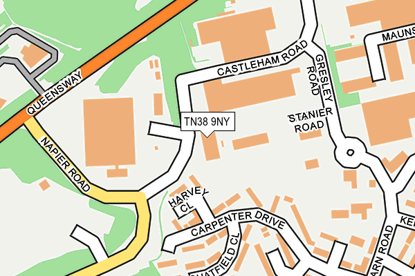
TN38 9NY is located in the Hollington electoral ward, within the local authority district of Hastings and the English Parliamentary constituency of Hastings and Rye. The Sub Integrated Care Board (ICB) Location is NHS Sussex ICB - 97R and the police force is Sussex. This postcode has been in use since September 1991.


GetTheData
Source: OS OpenMap – Local (Ordnance Survey)
Source: OS VectorMap District (Ordnance Survey)
Licence: Open Government Licence (requires attribution)
| Easting | 578434 |
| Northing | 112086 |
| Latitude | 50.880712 |
| Longitude | 0.535151 |
GetTheData
Source: Open Postcode Geo
Licence: Open Government Licence
| Country | England |
| Postcode District | TN38 |
| ➜ TN38 open data dashboard ➜ See where TN38 is on a map ➜ Where is Hastings? | |
GetTheData
Source: Land Registry Price Paid Data
Licence: Open Government Licence
Elevation or altitude of TN38 9NY as distance above sea level:
| Metres | Feet | |
|---|---|---|
| Elevation | 90m | 295ft |
Elevation is measured from the approximate centre of the postcode, to the nearest point on an OS contour line from OS Terrain 50, which has contour spacing of ten vertical metres.
➜ How high above sea level am I? Find the elevation of your current position using your device's GPS.
GetTheData
Source: Open Postcode Elevation
Licence: Open Government Licence
| Ward | Hollington |
| Constituency | Hastings And Rye |
GetTheData
Source: ONS Postcode Database
Licence: Open Government Licence
| December 2023 | Other theft | On or near Carpenter Drive | 283m |
| December 2023 | Other theft | On or near Coneyburrow Gardens | 289m |
| December 2023 | Anti-social behaviour | On or near Coneyburrow Gardens | 289m |
| ➜ Get more crime data in our Crime section | |||
GetTheData
Source: data.police.uk
Licence: Open Government Licence
| Stanier Road (Gresley Road) | Castleham Industrial Estate | 305m |
| Vg Scienta (Castleham Road) | Castleham Industrial Estate | 318m |
| Vg Scienta (Castleham Road) | Castleham Industrial Estate | 319m |
| Lancaster Road West (Gresley Road) | Castleham Industrial Estate | 391m |
| Carpenter Drive (Tile Barn Road) | Hollington | 424m |
| Crowhurst Station | 2.5km |
| West St Leonards Station | 3.1km |
| St Leonards Warrior Square Station | 3.3km |
GetTheData
Source: NaPTAN
Licence: Open Government Licence
GetTheData
Source: ONS Postcode Database
Licence: Open Government Licence


➜ Get more ratings from the Food Standards Agency
GetTheData
Source: Food Standards Agency
Licence: FSA terms & conditions
| Last Collection | |||
|---|---|---|---|
| Location | Mon-Fri | Sat | Distance |
| Tilebarn Road | 17:30 | 12:00 | 506m |
| Churchwood Drive | 17:30 | 12:15 | 531m |
| Telford Road | 18:45 | 12:00 | 601m |
GetTheData
Source: Dracos
Licence: Creative Commons Attribution-ShareAlike
| Facility | Distance |
|---|---|
| Tilekiln Recreation Ground Queensway Avenue South, St. Leonards-on-sea Grass Pitches | 250m |
| Hollington Youth Centre Wishing Tree Road North, St. Leonards-on-sea Sports Hall | 793m |
| Gibbons Memorial Field The Slides, St. Leonards-on-sea Grass Pitches | 908m |
GetTheData
Source: Active Places
Licence: Open Government Licence
| School | Phase of Education | Distance |
|---|---|---|
| Churchwood Primary Academy Church-in-the-Wood Lane, St Leonards-on-Sea, TN38 9PB | Primary | 637m |
| Hollington Primary School Hollington Old Lane, St. Leonards-on-Sea, TN38 9DS | Primary | 1.1km |
| New Horizons School (Part of the Sabden Multi Academy Trust) Beauchamp Road, St Leonards-on-Sea, TN38 9JU | Not applicable | 1.1km |
GetTheData
Source: Edubase
Licence: Open Government Licence
The below table lists the International Territorial Level (ITL) codes (formerly Nomenclature of Territorial Units for Statistics (NUTS) codes) and Local Administrative Units (LAU) codes for TN38 9NY:
| ITL 1 Code | Name |
|---|---|
| TLJ | South East (England) |
| ITL 2 Code | Name |
| TLJ2 | Surrey, East and West Sussex |
| ITL 3 Code | Name |
| TLJ22 | East Sussex CC |
| LAU 1 Code | Name |
| E07000062 | Hastings |
GetTheData
Source: ONS Postcode Directory
Licence: Open Government Licence
The below table lists the Census Output Area (OA), Lower Layer Super Output Area (LSOA), and Middle Layer Super Output Area (MSOA) for TN38 9NY:
| Code | Name | |
|---|---|---|
| OA | E00106606 | |
| LSOA | E01020995 | Hastings 003C |
| MSOA | E02004370 | Hastings 003 |
GetTheData
Source: ONS Postcode Directory
Licence: Open Government Licence
| TN38 9SG | Harvey Close | 156m |
| TN38 9AG | Queensway Avenue South | 204m |
| TN38 9RY | Coneyburrow Gardens | 251m |
| TN38 9SF | Chatfield Close | 264m |
| TN38 9SB | Carpenter Drive | 271m |
| TN38 9SE | Michelson Close | 272m |
| TN38 9RZ | Coneyburrow Gardens | 311m |
| TN38 9SD | Michelson Close | 348m |
| TN38 9RX | Carpenter Drive | 370m |
| TN38 9RU | Taylor Close | 383m |
GetTheData
Source: Open Postcode Geo; Land Registry Price Paid Data
Licence: Open Government Licence