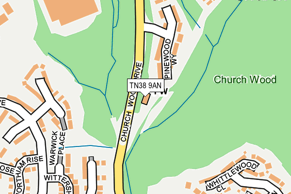
TN38 9AN is located in the Hollington electoral ward, within the local authority district of Hastings and the English Parliamentary constituency of Hastings and Rye. The Sub Integrated Care Board (ICB) Location is NHS Sussex ICB - 97R and the police force is Sussex. This postcode has been in use since June 2014.


GetTheData
Source: OS OpenMap – Local (Ordnance Survey)
Source: OS VectorMap District (Ordnance Survey)
Licence: Open Government Licence (requires attribution)
| Easting | 578207 |
| Northing | 111139 |
| Latitude | 50.872279 |
| Longitude | 0.531437 |
GetTheData
Source: Open Postcode Geo
Licence: Open Government Licence
| Country | England |
| Postcode District | TN38 |
| ➜ TN38 open data dashboard ➜ See where TN38 is on a map ➜ Where is Hastings? | |
GetTheData
Source: Land Registry Price Paid Data
Licence: Open Government Licence
Elevation or altitude of TN38 9AN as distance above sea level:
| Metres | Feet | |
|---|---|---|
| Elevation | 20m | 66ft |
Elevation is measured from the approximate centre of the postcode, to the nearest point on an OS contour line from OS Terrain 50, which has contour spacing of ten vertical metres.
➜ How high above sea level am I? Find the elevation of your current position using your device's GPS.
GetTheData
Source: Open Postcode Elevation
Licence: Open Government Licence
| Ward | Hollington |
| Constituency | Hastings And Rye |
GetTheData
Source: ONS Postcode Database
Licence: Open Government Licence
| October 2023 | Other theft | On or near Wainwright Close | 487m |
| September 2023 | Other theft | On or near Wainwright Close | 487m |
| June 2023 | Other theft | On or near Wainwright Close | 487m |
| ➜ Get more crime data in our Crime section | |||
GetTheData
Source: data.police.uk
Licence: Open Government Licence
| Pinewood Way (Church Wood Drive) | Hollington | 167m |
| Pinewood Way (Church Wood Drive) | Hollington | 168m |
| Hartfield Meadow (Icklesham Drive) | Hollington | 226m |
| Bodiam Drive (Church Wood Drive) | Hollington | 231m |
| Rocky Shaw (Bodiam Drive) | Hollington | 312m |
| West St Leonards Station | 2.2km |
| St Leonards Warrior Square Station | 2.7km |
| Crowhurst Station | 2.8km |
GetTheData
Source: NaPTAN
Licence: Open Government Licence
GetTheData
Source: ONS Postcode Database
Licence: Open Government Licence


➜ Get more ratings from the Food Standards Agency
GetTheData
Source: Food Standards Agency
Licence: FSA terms & conditions
| Last Collection | |||
|---|---|---|---|
| Location | Mon-Fri | Sat | Distance |
| Robsack | 17:30 | 12:15 | 331m |
| Whatlington Way | 17:30 | 12:15 | 436m |
| Churchwood Drive | 17:30 | 12:15 | 452m |
GetTheData
Source: Dracos
Licence: Creative Commons Attribution-ShareAlike
| Facility | Distance |
|---|---|
| Robsack Wood Primary Academy Whatlington Way, St. Leonards-on-sea Grass Pitches | 376m |
| Gibbons Memorial Field The Slides, St. Leonards-on-sea Grass Pitches | 753m |
| Tilekiln Recreation Ground Queensway Avenue South, St. Leonards-on-sea Grass Pitches | 809m |
GetTheData
Source: Active Places
Licence: Open Government Licence
| School | Phase of Education | Distance |
|---|---|---|
| Robsack Wood Primary Academy Whatlington Way, St Leonards-on-Sea, TN38 9TE | Primary | 378m |
| Churchwood Primary Academy Church-in-the-Wood Lane, St Leonards-on-Sea, TN38 9PB | Primary | 540m |
| New Horizons School (Part of the Sabden Multi Academy Trust) Beauchamp Road, St Leonards-on-Sea, TN38 9JU | Not applicable | 1.3km |
GetTheData
Source: Edubase
Licence: Open Government Licence
The below table lists the International Territorial Level (ITL) codes (formerly Nomenclature of Territorial Units for Statistics (NUTS) codes) and Local Administrative Units (LAU) codes for TN38 9AN:
| ITL 1 Code | Name |
|---|---|
| TLJ | South East (England) |
| ITL 2 Code | Name |
| TLJ2 | Surrey, East and West Sussex |
| ITL 3 Code | Name |
| TLJ22 | East Sussex CC |
| LAU 1 Code | Name |
| E07000062 | Hastings |
GetTheData
Source: ONS Postcode Directory
Licence: Open Government Licence
The below table lists the Census Output Area (OA), Lower Layer Super Output Area (LSOA), and Middle Layer Super Output Area (MSOA) for TN38 9AN:
| Code | Name | |
|---|---|---|
| OA | E00106609 | |
| LSOA | E01020996 | Hastings 003D |
| MSOA | E02004370 | Hastings 003 |
GetTheData
Source: ONS Postcode Directory
Licence: Open Government Licence
| TN38 9RR | Pinewood Way | 126m |
| TN38 9TL | Kensington Close | 196m |
| TN38 9PX | Warwick Place | 207m |
| TN38 9PT | Wittersham Rise | 208m |
| TN38 9PW | Wittersham Rise | 233m |
| TN38 9RJ | Plover Court | 241m |
| TN38 9SR | Whittlewood Close | 247m |
| TN38 9RH | Laurel Walk | 281m |
| TN38 9RQ | Curlew Court | 288m |
| TN38 9RL | Raven Court | 291m |
GetTheData
Source: Open Postcode Geo; Land Registry Price Paid Data
Licence: Open Government Licence