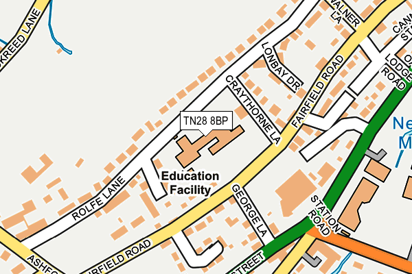
TN28 8BP is located in the New Romney electoral ward, within the local authority district of Folkestone and Hythe and the English Parliamentary constituency of Folkestone and Hythe. The Sub Integrated Care Board (ICB) Location is NHS Kent and Medway ICB - 91Q and the police force is Kent. This postcode has been in use since January 1980.


GetTheData
Source: OS OpenMap – Local (Ordnance Survey)
Source: OS VectorMap District (Ordnance Survey)
Licence: Open Government Licence (requires attribution)
| Easting | 606585 |
| Northing | 125145 |
| Latitude | 50.988623 |
| Longitude | 0.942205 |
GetTheData
Source: Open Postcode Geo
Licence: Open Government Licence
| Country | England |
| Postcode District | TN28 |
| ➜ TN28 open data dashboard ➜ See where TN28 is on a map ➜ Where is New Romney? | |
GetTheData
Source: Land Registry Price Paid Data
Licence: Open Government Licence
Elevation or altitude of TN28 8BP as distance above sea level:
| Metres | Feet | |
|---|---|---|
| Elevation | 0m | 0ft |
Elevation is measured from the approximate centre of the postcode, to the nearest point on an OS contour line from OS Terrain 50, which has contour spacing of ten vertical metres.
➜ How high above sea level am I? Find the elevation of your current position using your device's GPS.
GetTheData
Source: Open Postcode Elevation
Licence: Open Government Licence
| Ward | New Romney |
| Constituency | Folkestone And Hythe |
GetTheData
Source: ONS Postcode Database
Licence: Open Government Licence
| January 2024 | Criminal damage and arson | On or near Tritton Lane | 286m |
| December 2023 | Anti-social behaviour | On or near Tritton Lane | 286m |
| November 2023 | Shoplifting | On or near Tritton Lane | 286m |
| ➜ Get more crime data in our Crime section | |||
GetTheData
Source: data.police.uk
Licence: Open Government Licence
| The Ship (High Street) | New Romney | 182m |
| The Ship (High Street) | New Romney | 193m |
| Sainsburys (Dymchurch Road) | New Romney | 217m |
| Marsh Academy (Station Road) | New Romney | 296m |
| Cannon Street (Dymchurch Road) | New Romney | 366m |
| New Romney Station (Rhdr) | New Romney | 886m |
| Romney Warren Halt (Rhdr) | New Romney | 1,611m |
GetTheData
Source: NaPTAN
Licence: Open Government Licence
GetTheData
Source: ONS Postcode Database
Licence: Open Government Licence


➜ Get more ratings from the Food Standards Agency
GetTheData
Source: Food Standards Agency
Licence: FSA terms & conditions
| Last Collection | |||
|---|---|---|---|
| Location | Mon-Fri | Sat | Distance |
| New Romney Post Office | 17:15 | 11:45 | 470m |
| Gordons Villas | 17:00 | 09:00 | 763m |
| Littlestone Golf Club | 16:15 | 09:00 | 1,842m |
GetTheData
Source: Dracos
Licence: Creative Commons Attribution-ShareAlike
| Facility | Distance |
|---|---|
| Al's Gym North Street, New Romney Health and Fitness Gym | 418m |
| The Marsh Academy Leisure Centre Station Road, New Romney Sports Hall, Health and Fitness Gym, Grass Pitches, Studio, Squash Courts | 484m |
| New Romney Sports Club Station Road, New Romney Grass Pitches | 586m |
GetTheData
Source: Active Places
Licence: Open Government Licence
| School | Phase of Education | Distance |
|---|---|---|
| St Nicholas Church of England Primary Academy Fairfield Road, New Romney, TN28 8BP | Primary | 1m |
| The Marsh Academy Station Road, New Romney, TN28 8BB | Secondary | 484m |
| Lighthouse On the Marsh Unit 4, Mountfield Road, New Romney, TN28 8LH | Not applicable | 866m |
GetTheData
Source: Edubase
Licence: Open Government Licence
The below table lists the International Territorial Level (ITL) codes (formerly Nomenclature of Territorial Units for Statistics (NUTS) codes) and Local Administrative Units (LAU) codes for TN28 8BP:
| ITL 1 Code | Name |
|---|---|
| TLJ | South East (England) |
| ITL 2 Code | Name |
| TLJ4 | Kent |
| ITL 3 Code | Name |
| TLJ44 | East Kent |
| LAU 1 Code | Name |
| E07000112 | Folkestone and Hythe |
GetTheData
Source: ONS Postcode Directory
Licence: Open Government Licence
The below table lists the Census Output Area (OA), Lower Layer Super Output Area (LSOA), and Middle Layer Super Output Area (MSOA) for TN28 8BP:
| Code | Name | |
|---|---|---|
| OA | E00124565 | |
| LSOA | E01024539 | Shepway 012C |
| MSOA | E02005113 | Shepway 012 |
GetTheData
Source: ONS Postcode Directory
Licence: Open Government Licence
| TN28 8JA | Fairfield Close | 88m |
| TN28 8BL | Craythorne Lane | 101m |
| TN28 8HW | Fairfield Road | 103m |
| TN28 8HS | Fairfield Road | 133m |
| TN28 8AB | Lonbay Drive | 136m |
| TN28 8BS | George Lane | 139m |
| TN28 8JP | Rolfe Lane | 147m |
| TN28 8HN | Fairfield Road | 163m |
| TN28 8HT | Mabledon Close | 168m |
| TN28 8BA | Dymchurch Road | 180m |
GetTheData
Source: Open Postcode Geo; Land Registry Price Paid Data
Licence: Open Government Licence