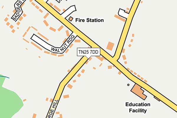
TN25 7DD lies on Forge Hill in Aldington, Ashford. TN25 7DD is located in the Saxon Shore electoral ward, within the local authority district of Ashford and the English Parliamentary constituency of Folkestone and Hythe. The Sub Integrated Care Board (ICB) Location is NHS Kent and Medway ICB - 91Q and the police force is Kent. This postcode has been in use since February 2007.


GetTheData
Source: OS OpenMap – Local (Ordnance Survey)
Source: OS VectorMap District (Ordnance Survey)
Licence: Open Government Licence (requires attribution)
| Easting | 606280 |
| Northing | 136564 |
| Latitude | 51.091279 |
| Longitude | 0.944360 |
GetTheData
Source: Open Postcode Geo
Licence: Open Government Licence
| Street | Forge Hill |
| Locality | Aldington |
| Town/City | Ashford |
| Country | England |
| Postcode District | TN25 |
| ➜ TN25 open data dashboard ➜ See where TN25 is on a map ➜ Where is Aldington? | |
GetTheData
Source: Land Registry Price Paid Data
Licence: Open Government Licence
Elevation or altitude of TN25 7DD as distance above sea level:
| Metres | Feet | |
|---|---|---|
| Elevation | 80m | 262ft |
Elevation is measured from the approximate centre of the postcode, to the nearest point on an OS contour line from OS Terrain 50, which has contour spacing of ten vertical metres.
➜ How high above sea level am I? Find the elevation of your current position using your device's GPS.
GetTheData
Source: Open Postcode Elevation
Licence: Open Government Licence
| Ward | Saxon Shore |
| Constituency | Folkestone And Hythe |
GetTheData
Source: ONS Postcode Database
Licence: Open Government Licence
| June 2022 | Violence and sexual offences | On or near Ragstone Hollow | 226m |
| June 2022 | Violence and sexual offences | On or near Ragstone Hollow | 226m |
| June 2022 | Violence and sexual offences | On or near Longsfield | 338m |
| ➜ Forge Hill crime map and outcomes | |||
GetTheData
Source: data.police.uk
Licence: Open Government Licence
| Walnut Tree (Forge Hill) | Aldington | 40m |
| Walnut Tree Inn (Roman Road) | Aldington | 40m |
| Walnut Tree (Forge Hill) | Aldington | 57m |
| Fire Station (Roman Road) | Aldington | 157m |
| Fire Station (Roman Road) | Aldington | 201m |
GetTheData
Source: NaPTAN
Licence: Open Government Licence
| Percentage of properties with Next Generation Access | 100.0% |
| Percentage of properties with Superfast Broadband | 100.0% |
| Percentage of properties with Ultrafast Broadband | 0.0% |
| Percentage of properties with Full Fibre Broadband | 0.0% |
Superfast Broadband is between 30Mbps and 300Mbps
Ultrafast Broadband is > 300Mbps
| Percentage of properties unable to receive 2Mbps | 0.0% |
| Percentage of properties unable to receive 5Mbps | 0.0% |
| Percentage of properties unable to receive 10Mbps | 0.0% |
| Percentage of properties unable to receive 30Mbps | 0.0% |
GetTheData
Source: Ofcom
Licence: Ofcom Terms of Use (requires attribution)
GetTheData
Source: ONS Postcode Database
Licence: Open Government Licence


➜ Get more ratings from the Food Standards Agency
GetTheData
Source: Food Standards Agency
Licence: FSA terms & conditions
| Last Collection | |||
|---|---|---|---|
| Location | Mon-Fri | Sat | Distance |
| Aldington Corner | 16:00 | 10:00 | 53m |
| Aldington Post Office | 17:00 | 10:00 | 513m |
| Bonnington | 16:30 | 09:00 | 926m |
GetTheData
Source: Dracos
Licence: Creative Commons Attribution-ShareAlike
| Facility | Distance |
|---|---|
| Reynolds Playing Fields Goldwell Lane, Aldington Grass Pitches, Outdoor Tennis Courts, Health and Fitness Gym | 106m |
| Aldington Village Hall Roman Road, Aldington, Ashford Sports Hall, Grass Pitches, Outdoor Tennis Courts | 154m |
| Aldington Primary School Roman Road, Aldington, Ashford Grass Pitches | 179m |
GetTheData
Source: Active Places
Licence: Open Government Licence
| School | Phase of Education | Distance |
|---|---|---|
| Aldington Primary School Roman Road, Aldington, Ashford, TN25 7EE | Primary | 179m |
| Caldecott Foundation School Station Road, Smeeth, Ashford, TN25 6PW | Not applicable | 2.9km |
| Mersham Primary School Church Road, Mersham, Ashford, TN25 6NU | Primary | 3km |
GetTheData
Source: Edubase
Licence: Open Government Licence
The below table lists the International Territorial Level (ITL) codes (formerly Nomenclature of Territorial Units for Statistics (NUTS) codes) and Local Administrative Units (LAU) codes for TN25 7DD:
| ITL 1 Code | Name |
|---|---|
| TLJ | South East (England) |
| ITL 2 Code | Name |
| TLJ4 | Kent |
| ITL 3 Code | Name |
| TLJ45 | Mid Kent |
| LAU 1 Code | Name |
| E07000105 | Ashford |
GetTheData
Source: ONS Postcode Directory
Licence: Open Government Licence
The below table lists the Census Output Area (OA), Lower Layer Super Output Area (LSOA), and Middle Layer Super Output Area (MSOA) for TN25 7DD:
| Code | Name | |
|---|---|---|
| OA | E00121907 | |
| LSOA | E01024014 | Ashford 010B |
| MSOA | E02005005 | Ashford 010 |
GetTheData
Source: ONS Postcode Directory
Licence: Open Government Licence
| TN25 7DS | Roman Road | 35m |
| TN25 7DW | Walnut Ridge | 105m |
| TN25 7EN | The Corner | 119m |
| TN25 7DZ | Church View | 156m |
| TN25 7EE | Goldwell Houses | 160m |
| TN25 7DY | Goldwell Close | 172m |
| TN25 7DT | Forge Hill | 197m |
| TN25 7DR | Earlsfield | 199m |
| TN25 7DN | Mount Pleasant | 209m |
| TN25 7DL | Ragstone Hollow | 238m |
GetTheData
Source: Open Postcode Geo; Land Registry Price Paid Data
Licence: Open Government Licence