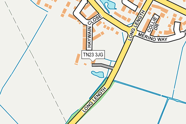
TN23 3JG is located in the Roman electoral ward, within the local authority district of Ashford and the English Parliamentary constituency of Ashford. The Sub Integrated Care Board (ICB) Location is NHS Kent and Medway ICB - 91Q and the police force is Kent. This postcode has been in use since January 1980.


GetTheData
Source: OS OpenMap – Local (Ordnance Survey)
Source: OS VectorMap District (Ordnance Survey)
Licence: Open Government Licence (requires attribution)
| Easting | 599205 |
| Northing | 139971 |
| Latitude | 51.124376 |
| Longitude | 0.845310 |
GetTheData
Source: Open Postcode Geo
Licence: Open Government Licence
| Country | England |
| Postcode District | TN23 |
➜ See where TN23 is on a map ➜ Where is Ashford? | |
GetTheData
Source: Land Registry Price Paid Data
Licence: Open Government Licence
Elevation or altitude of TN23 3JG as distance above sea level:
| Metres | Feet | |
|---|---|---|
| Elevation | 40m | 131ft |
Elevation is measured from the approximate centre of the postcode, to the nearest point on an OS contour line from OS Terrain 50, which has contour spacing of ten vertical metres.
➜ How high above sea level am I? Find the elevation of your current position using your device's GPS.
GetTheData
Source: Open Postcode Elevation
Licence: Open Government Licence
| Ward | Roman |
| Constituency | Ashford |
GetTheData
Source: ONS Postcode Database
Licence: Open Government Licence
| Haywain Close (Coulter Road) | Bridewell | 139m |
| Haywain Close (Coulter Road) | Bridewell | 156m |
| Down Court (Washford Farm Road) | Washford Farm | 356m |
| Down Court (Washford Farm Road) | Washford Farm | 371m |
| Wivenhoe (Washford Farm Road) | Washford Farm | 395m |
| Ashford International Station | 3km |
GetTheData
Source: NaPTAN
Licence: Open Government Licence
GetTheData
Source: ONS Postcode Database
Licence: Open Government Licence


➜ Get more ratings from the Food Standards Agency
GetTheData
Source: Food Standards Agency
Licence: FSA terms & conditions
| Last Collection | |||
|---|---|---|---|
| Location | Mon-Fri | Sat | Distance |
| Coulter Road | 17:15 | 12:15 | 524m |
| Repton Park | 17:30 | 11:45 | 525m |
| Langney Drive | 17:15 | 11:45 | 743m |
GetTheData
Source: Dracos
Licence: Creative Commons Attribution-ShareAlike
| Risk of TN23 3JG flooding from rivers and sea | Medium |
| ➜ TN23 3JG flood map | |
GetTheData
Source: Open Flood Risk by Postcode
Licence: Open Government Licence
The below table lists the International Territorial Level (ITL) codes (formerly Nomenclature of Territorial Units for Statistics (NUTS) codes) and Local Administrative Units (LAU) codes for TN23 3JG:
| ITL 1 Code | Name |
|---|---|
| TLJ | South East (England) |
| ITL 2 Code | Name |
| TLJ4 | Kent |
| ITL 3 Code | Name |
| TLJ45 | Mid Kent |
| LAU 1 Code | Name |
| E07000105 | Ashford |
GetTheData
Source: ONS Postcode Directory
Licence: Open Government Licence
The below table lists the Census Output Area (OA), Lower Layer Super Output Area (LSOA), and Middle Layer Super Output Area (MSOA) for TN23 3JG:
| Code | Name | |
|---|---|---|
| OA | E00167600 | |
| LSOA | E01032816 | Ashford 008E |
| MSOA | E02005003 | Ashford 008 |
GetTheData
Source: ONS Postcode Directory
Licence: Open Government Licence
| TN23 3QL | Hay Wain Close | 142m |
| TN23 3GR | Collie Drive | 249m |
| TN23 3JB | Harrow Way | 254m |
| TN23 3JF | 274m | |
| TN23 3GS | Merino Way | 277m |
| TN23 3JA | Barley Way | 282m |
| TN23 3GT | Shepherd Close | 285m |
| TN23 3RH | Hestia Way | 315m |
| TN23 5YJ | Down Court | 331m |
| TN23 5YD | Washford Farm Road | 354m |
GetTheData
Source: Open Postcode Geo; Land Registry Price Paid Data
Licence: Open Government Licence