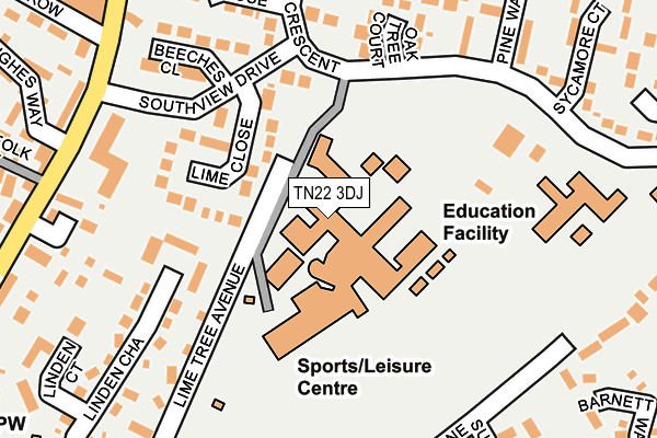
TN22 3DJ is located in the Uckfield East electoral ward, within the local authority district of Wealden and the English Parliamentary constituency of Wealden. The Sub Integrated Care Board (ICB) Location is NHS Sussex ICB - 97R and the police force is Sussex. This postcode has been in use since January 1980.


GetTheData
Source: OS OpenMap – Local (Ordnance Survey)
Source: OS VectorMap District (Ordnance Survey)
Licence: Open Government Licence (requires attribution)
| Easting | 547779 |
| Northing | 121659 |
| Latitude | 50.975385 |
| Longitude | 0.103602 |
GetTheData
Source: Open Postcode Geo
Licence: Open Government Licence
| Country | England |
| Postcode District | TN22 |
| ➜ TN22 open data dashboard ➜ See where TN22 is on a map ➜ Where is Uckfield? | |
GetTheData
Source: Land Registry Price Paid Data
Licence: Open Government Licence
Elevation or altitude of TN22 3DJ as distance above sea level:
| Metres | Feet | |
|---|---|---|
| Elevation | 50m | 164ft |
Elevation is measured from the approximate centre of the postcode, to the nearest point on an OS contour line from OS Terrain 50, which has contour spacing of ten vertical metres.
➜ How high above sea level am I? Find the elevation of your current position using your device's GPS.
GetTheData
Source: Open Postcode Elevation
Licence: Open Government Licence
| Ward | Uckfield East |
| Constituency | Wealden |
GetTheData
Source: ONS Postcode Database
Licence: Open Government Licence
| July 2023 | Vehicle crime | On or near Nevill Road | 492m |
| May 2023 | Anti-social behaviour | On or near Nevill Road | 492m |
| April 2023 | Other crime | On or near Nevill Road | 492m |
| ➜ Get more crime data in our Crime section | |||
GetTheData
Source: data.police.uk
Licence: Open Government Licence
| Uckfield College (Downsview Crescent) | Uckfield | 102m |
| Larnach Close (Downsview Crescent) | Uckfield | 186m |
| Streatfield House (Southview Drive) | Uckfield | 249m |
| Montacute Way (Downsview Crescent) | Uckfield | 257m |
| North Row (High Street) | Uckfield | 287m |
| Uckfield Station | 0.9km |
| Buxted Station | 2.5km |
GetTheData
Source: NaPTAN
Licence: Open Government Licence
GetTheData
Source: ONS Postcode Database
Licence: Open Government Licence


➜ Get more ratings from the Food Standards Agency
GetTheData
Source: Food Standards Agency
Licence: FSA terms & conditions
| Last Collection | |||
|---|---|---|---|
| Location | Mon-Fri | Sat | Distance |
| Manor Park Post Office | 17:15 | 12:00 | 275m |
| Downsview | 17:15 | 09:00 | 339m |
| High Street North | 18:30 | 09:00 | 450m |
GetTheData
Source: Dracos
Licence: Creative Commons Attribution-ShareAlike
| Facility | Distance |
|---|---|
| Uckfield College Downsview Crescent, Uckfield Grass Pitches, Artificial Grass Pitch, Sports Hall | 135m |
| Uckfield Leisure Centre Downsview Crescent, Uckfield Sports Hall, Swimming Pool, Health and Fitness Gym, Studio, Squash Courts | 195m |
| Uckfield Rugby Club Nevill Road, Uckfield Grass Pitches | 674m |
GetTheData
Source: Active Places
Licence: Open Government Licence
| School | Phase of Education | Distance |
|---|---|---|
| Uckfield College Downsview Crescent, Uckfield, TN22 3DJ | Secondary | 135m |
| Manor Primary School Downsview Crescent, Uckfield, TN22 1UB | Primary | 249m |
| Rocks Park Primary School Lashbrooks Road, Uckfield, TN22 2AY | Primary | 1km |
GetTheData
Source: Edubase
Licence: Open Government Licence
The below table lists the International Territorial Level (ITL) codes (formerly Nomenclature of Territorial Units for Statistics (NUTS) codes) and Local Administrative Units (LAU) codes for TN22 3DJ:
| ITL 1 Code | Name |
|---|---|
| TLJ | South East (England) |
| ITL 2 Code | Name |
| TLJ2 | Surrey, East and West Sussex |
| ITL 3 Code | Name |
| TLJ22 | East Sussex CC |
| LAU 1 Code | Name |
| E07000065 | Wealden |
GetTheData
Source: ONS Postcode Directory
Licence: Open Government Licence
The below table lists the Census Output Area (OA), Lower Layer Super Output Area (LSOA), and Middle Layer Super Output Area (MSOA) for TN22 3DJ:
| Code | Name | |
|---|---|---|
| OA | E00107811 | |
| LSOA | E01021223 | Wealden 009C |
| MSOA | E02004411 | Wealden 009 |
GetTheData
Source: ONS Postcode Directory
Licence: Open Government Licence
| TN22 1TT | Oak Tree Court | 92m |
| TN22 1TG | Downsview Crescent | 110m |
| TN22 1TS | Woodlands Close | 121m |
| TN22 1TU | Pine Walk | 133m |
| TN22 1TD | Lime Tree Avenue | 146m |
| TN22 1TX | Downsview Crescent | 165m |
| TN22 1TY | Sycamore Court | 166m |
| TN22 1TA | Southview Drive | 172m |
| TN22 1TJ | Downsview Crescent | 177m |
| TN22 1TR | Montacute Way | 197m |
GetTheData
Source: Open Postcode Geo; Land Registry Price Paid Data
Licence: Open Government Licence