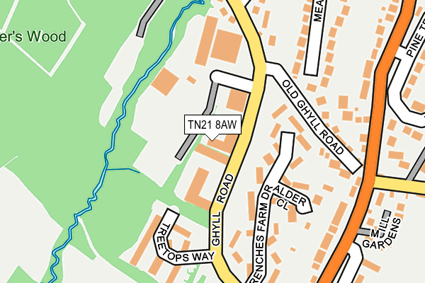
TN21 8AW lies on Ghyll Industrial Estate in Heathfield. TN21 8AW is located in the Heathfield South electoral ward, within the local authority district of Wealden and the English Parliamentary constituency of Bexhill and Battle. The Sub Integrated Care Board (ICB) Location is NHS Sussex ICB - 97R and the police force is Sussex. This postcode has been in use since April 1987.


GetTheData
Source: OS OpenMap – Local (Ordnance Survey)
Source: OS VectorMap District (Ordnance Survey)
Licence: Open Government Licence (requires attribution)
| Easting | 558151 |
| Northing | 120372 |
| Latitude | 50.961073 |
| Longitude | 0.250636 |
GetTheData
Source: Open Postcode Geo
Licence: Open Government Licence
| Street | Ghyll Industrial Estate |
| Town/City | Heathfield |
| Country | England |
| Postcode District | TN21 |
| ➜ TN21 open data dashboard ➜ See where TN21 is on a map ➜ Where is Heathfield? | |
GetTheData
Source: Land Registry Price Paid Data
Licence: Open Government Licence
Elevation or altitude of TN21 8AW as distance above sea level:
| Metres | Feet | |
|---|---|---|
| Elevation | 110m | 361ft |
Elevation is measured from the approximate centre of the postcode, to the nearest point on an OS contour line from OS Terrain 50, which has contour spacing of ten vertical metres.
➜ How high above sea level am I? Find the elevation of your current position using your device's GPS.
GetTheData
Source: Open Postcode Elevation
Licence: Open Government Licence
| Ward | Heathfield South |
| Constituency | Bexhill And Battle |
GetTheData
Source: ONS Postcode Database
Licence: Open Government Licence
| June 2022 | Vehicle crime | On or near Theobalds Green | 253m |
| June 2022 | Anti-social behaviour | On or near Meadow Way | 270m |
| June 2022 | Theft from the person | On or near Holly Close | 369m |
| ➜ Get more crime data in our Crime section | |||
GetTheData
Source: data.police.uk
Licence: Open Government Licence
| Swaines Way (Ghyll Road) | Heathfield | 209m |
| Sandy Cross Lane (Halisham Road) | Sandy Cross | 226m |
| Ghyll Road | Sandy Cross | 230m |
| Sandy Cross Lane (Hailsham Road) | Sandy Cross | 235m |
| Ghyl Road (Theobalds Green) | Sandy Cross | 270m |
GetTheData
Source: NaPTAN
Licence: Open Government Licence
| Median download speed | 60.0Mbps |
| Average download speed | 56.1Mbps |
| Maximum download speed | 80.00Mbps |
| Median upload speed | 15.0Mbps |
| Average upload speed | 13.5Mbps |
| Maximum upload speed | 20.00Mbps |
GetTheData
Source: Ofcom
Licence: Ofcom Terms of Use (requires attribution)
Estimated total energy consumption in TN21 8AW by fuel type, 2015.
| Consumption (kWh) | 142,715 |
|---|---|
| Meter count | 11 |
| Mean (kWh/meter) | 12,974 |
| Median (kWh/meter) | 4,679 |
GetTheData
Source: Postcode level gas estimates: 2015 (experimental)
Source: Postcode level electricity estimates: 2015 (experimental)
Licence: Open Government Licence
GetTheData
Source: ONS Postcode Database
Licence: Open Government Licence


➜ Get more ratings from the Food Standards Agency
GetTheData
Source: Food Standards Agency
Licence: FSA terms & conditions
| Last Collection | |||
|---|---|---|---|
| Location | Mon-Fri | Sat | Distance |
| Station House | 16:45 | 09:00 | 966m |
| Heathfield Post Office | 17:30 | 11:30 | 1,028m |
| Tilsmore Corner | 17:00 | 09:00 | 1,031m |
GetTheData
Source: Dracos
Licence: Creative Commons Attribution-ShareAlike
| Facility | Distance |
|---|---|
| Sheepsetting Lane Recreation Ground Sheepsetting Lane, Cross In Hand, Heathfield Grass Pitches | 1.1km |
| Tower Street Recreation Ground Tower Street, Heathfield Grass Pitches | 1.3km |
| Heathfield Park Cricket Club School Hill, Old Heathfield Grass Pitches | 1.7km |
GetTheData
Source: Active Places
Licence: Open Government Licence
| School | Phase of Education | Distance |
|---|---|---|
| Parkside Community Primary School Beechwood Lane, Heathfield, TN21 8QQ | Primary | 916m |
| Cross-in-Hand Church of England Primary School Sheepsetting Lane, Cross in Hand, Heathfield, TN21 0XG | Primary | 1km |
| All Saints' and St Richard's Church of England Primary School School Hill, Old Heathfield, Heathfield, TN21 9AE | Primary | 1.7km |
GetTheData
Source: Edubase
Licence: Open Government Licence
The below table lists the International Territorial Level (ITL) codes (formerly Nomenclature of Territorial Units for Statistics (NUTS) codes) and Local Administrative Units (LAU) codes for TN21 8AW:
| ITL 1 Code | Name |
|---|---|
| TLJ | South East (England) |
| ITL 2 Code | Name |
| TLJ2 | Surrey, East and West Sussex |
| ITL 3 Code | Name |
| TLJ22 | East Sussex CC |
| LAU 1 Code | Name |
| E07000065 | Wealden |
GetTheData
Source: ONS Postcode Directory
Licence: Open Government Licence
The below table lists the Census Output Area (OA), Lower Layer Super Output Area (LSOA), and Middle Layer Super Output Area (MSOA) for TN21 8AW:
| Code | Name | |
|---|---|---|
| OA | E00107658 | |
| LSOA | E01021193 | Wealden 010D |
| MSOA | E02004412 | Wealden 010 |
GetTheData
Source: ONS Postcode Directory
Licence: Open Government Licence
| TN21 8BQ | Frenches Farm Drive | 78m |
| TN21 8BZ | Frenches Farm Drive | 127m |
| TN21 8BX | Rowan Close | 143m |
| TN21 8BY | Alder Close | 145m |
| TN21 8FN | Treetops Way | 163m |
| TN21 0AJ | Ghyll Road | 174m |
| TN21 8BW | Frenches Farm Drive | 189m |
| TN21 8BP | Old Ghyll Road | 192m |
| TN21 8AZ | Frenches Farm Drive | 193m |
| TN21 8AS | Hailsham Road | 224m |
GetTheData
Source: Open Postcode Geo; Land Registry Price Paid Data
Licence: Open Government Licence