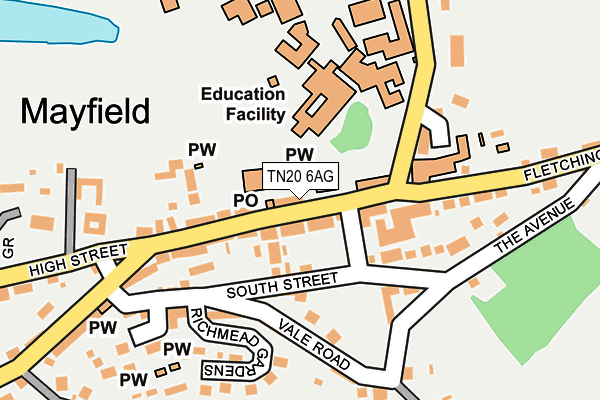
TN20 6AG lies on High Street in Mayfield. TN20 6AG is located in the Mayfield & Five Ashes electoral ward, within the local authority district of Wealden and the English Parliamentary constituency of Wealden. The Sub Integrated Care Board (ICB) Location is NHS Sussex ICB - 97R and the police force is Sussex. This postcode has been in use since January 1980.


GetTheData
Source: OS OpenMap – Local (Ordnance Survey)
Source: OS VectorMap District (Ordnance Survey)
Licence: Open Government Licence (requires attribution)
| Easting | 558712 |
| Northing | 127017 |
| Latitude | 51.020622 |
| Longitude | 0.261547 |
GetTheData
Source: Open Postcode Geo
Licence: Open Government Licence
| Street | High Street |
| Town/City | Mayfield |
| Country | England |
| Postcode District | TN20 |
| ➜ TN20 open data dashboard ➜ See where TN20 is on a map ➜ Where is Mayfield? | |
GetTheData
Source: Land Registry Price Paid Data
Licence: Open Government Licence
Elevation or altitude of TN20 6AG as distance above sea level:
| Metres | Feet | |
|---|---|---|
| Elevation | 140m | 459ft |
Elevation is measured from the approximate centre of the postcode, to the nearest point on an OS contour line from OS Terrain 50, which has contour spacing of ten vertical metres.
➜ How high above sea level am I? Find the elevation of your current position using your device's GPS.
GetTheData
Source: Open Postcode Elevation
Licence: Open Government Licence
| Ward | Mayfield & Five Ashes |
| Constituency | Wealden |
GetTheData
Source: ONS Postcode Database
Licence: Open Government Licence
| December 2023 | Violence and sexual offences | On or near Parking Area | 110m |
| November 2023 | Violence and sexual offences | On or near Parking Area | 110m |
| July 2023 | Violence and sexual offences | On or near Parking Area | 110m |
| ➜ High Street crime map and outcomes | |||
GetTheData
Source: data.police.uk
Licence: Open Government Licence
| Post Office (High Street) | Mayfield | 31m |
| Post Office (High Street) | Mayfield | 35m |
| Fire Station (Tunbridge Wells Road) | Mayfield | 313m |
| Fire Station (Tunbridge Wells Road) | Mayfield | 319m |
| Church (Station Road) | Mayfield | 579m |
GetTheData
Source: NaPTAN
Licence: Open Government Licence
| Percentage of properties with Next Generation Access | 100.0% |
| Percentage of properties with Superfast Broadband | 100.0% |
| Percentage of properties with Ultrafast Broadband | 0.0% |
| Percentage of properties with Full Fibre Broadband | 0.0% |
Superfast Broadband is between 30Mbps and 300Mbps
Ultrafast Broadband is > 300Mbps
| Percentage of properties unable to receive 2Mbps | 0.0% |
| Percentage of properties unable to receive 5Mbps | 0.0% |
| Percentage of properties unable to receive 10Mbps | 0.0% |
| Percentage of properties unable to receive 30Mbps | 0.0% |
GetTheData
Source: Ofcom
Licence: Ofcom Terms of Use (requires attribution)
GetTheData
Source: ONS Postcode Database
Licence: Open Government Licence


➜ Get more ratings from the Food Standards Agency
GetTheData
Source: Food Standards Agency
Licence: FSA terms & conditions
| Last Collection | |||
|---|---|---|---|
| Location | Mon-Fri | Sat | Distance |
| Mayfield Post Office | 17:15 | 10:45 | 65m |
| Victoria Road | 17:00 | 10:00 | 597m |
| Mayfield Station | 17:00 | 10:00 | 787m |
GetTheData
Source: Dracos
Licence: Creative Commons Attribution-ShareAlike
| Facility | Distance |
|---|---|
| Mayfield Girls School High Street, Mayfield Health and Fitness Gym, Grass Pitches, Artificial Grass Pitch, Sports Hall, Swimming Pool, Studio, Outdoor Tennis Courts | 117m |
| Court Meadow Playing Field Tunbridge Wells Road, Mayfield Grass Pitches | 328m |
| Mayfield Lawn Tennis Club Station Road, Mayfield Outdoor Tennis Courts | 518m |
GetTheData
Source: Active Places
Licence: Open Government Licence
| School | Phase of Education | Distance |
|---|---|---|
| Mayfield Church of England Primary School Fletching Street, Mayfield, TN20 6TA | Primary | 95m |
| Mayfield School The Old Palace, High Street, Mayfield, TN20 6PH | Not applicable | 96m |
| Skippers Hill Manor Preparatory School Five Ashes, Mayfield, East Sussex, Mayfield, TN20 6HR | Not applicable | 3.4km |
GetTheData
Source: Edubase
Licence: Open Government Licence
The below table lists the International Territorial Level (ITL) codes (formerly Nomenclature of Territorial Units for Statistics (NUTS) codes) and Local Administrative Units (LAU) codes for TN20 6AG:
| ITL 1 Code | Name |
|---|---|
| TLJ | South East (England) |
| ITL 2 Code | Name |
| TLJ2 | Surrey, East and West Sussex |
| ITL 3 Code | Name |
| TLJ22 | East Sussex CC |
| LAU 1 Code | Name |
| E07000065 | Wealden |
GetTheData
Source: ONS Postcode Directory
Licence: Open Government Licence
The below table lists the Census Output Area (OA), Lower Layer Super Output Area (LSOA), and Middle Layer Super Output Area (MSOA) for TN20 6AG:
| Code | Name | |
|---|---|---|
| OA | E00107704 | |
| LSOA | E01021202 | Wealden 005A |
| MSOA | E02004407 | Wealden 005 |
GetTheData
Source: ONS Postcode Directory
Licence: Open Government Licence
| TN20 6AA | High Street | 51m |
| TN20 6AJ | Star Mews | 83m |
| TN20 6BE | Holders Lane | 84m |
| TN20 6AB | High Street | 96m |
| TN20 6PA | St Leonards Lane | 115m |
| TN20 6DD | South Street | 117m |
| TN20 6TT | Sunnybank Close | 128m |
| TN20 6AY | The Avenue | 132m |
| TN20 6AN | North Street | 134m |
| TN20 6BB | Vale Road | 156m |
GetTheData
Source: Open Postcode Geo; Land Registry Price Paid Data
Licence: Open Government Licence