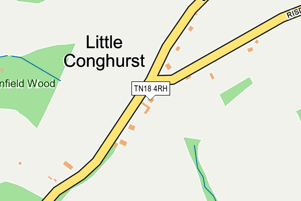
TN18 4RH is located in the Hawkhurst and Sandhurst electoral ward, within the local authority district of Tunbridge Wells and the English Parliamentary constituency of Tunbridge Wells. The Sub Integrated Care Board (ICB) Location is NHS Kent and Medway ICB - 91Q and the police force is Kent. This postcode has been in use since June 2001.


GetTheData
Source: OS OpenMap – Local (Ordnance Survey)
Source: OS VectorMap District (Ordnance Survey)
Licence: Open Government Licence (requires attribution)
| Easting | 577274 |
| Northing | 129246 |
| Latitude | 51.035231 |
| Longitude | 0.527001 |
GetTheData
Source: Open Postcode Geo
Licence: Open Government Licence
| Country | England |
| Postcode District | TN18 |
| ➜ TN18 open data dashboard ➜ See where TN18 is on a map ➜ Where is Little Conghurst? | |
GetTheData
Source: Land Registry Price Paid Data
Licence: Open Government Licence
Elevation or altitude of TN18 4RH as distance above sea level:
| Metres | Feet | |
|---|---|---|
| Elevation | 70m | 230ft |
Elevation is measured from the approximate centre of the postcode, to the nearest point on an OS contour line from OS Terrain 50, which has contour spacing of ten vertical metres.
➜ How high above sea level am I? Find the elevation of your current position using your device's GPS.
GetTheData
Source: Open Postcode Elevation
Licence: Open Government Licence
| Ward | Hawkhurst And Sandhurst |
| Constituency | Tunbridge Wells |
GetTheData
Source: ONS Postcode Database
Licence: Open Government Licence
| July 2023 | Burglary | On or near Conghurst Lane | 414m |
| June 2022 | Other theft | On or near Risden Road | 44m |
| March 2022 | Violence and sexual offences | On or near Risden Road | 389m |
| ➜ Get more crime data in our Crime section | |||
GetTheData
Source: data.police.uk
Licence: Open Government Licence
| Foxhole Lane (Rye Road) | Hawkhurst | 695m |
| Foxhole Lane (Rye Road) | Hawkhurst | 721m |
| Fir Tree Cottages (Rye Road) | Hawkhurst | 760m |
| Fir Tree Cottages (Rye Road) | Hawkhurst | 764m |
| Tudor Hall (Rye Road) | Hawkhurst | 1,107m |
GetTheData
Source: NaPTAN
Licence: Open Government Licence
| Percentage of properties with Next Generation Access | 100.0% |
| Percentage of properties with Superfast Broadband | 100.0% |
| Percentage of properties with Ultrafast Broadband | 0.0% |
| Percentage of properties with Full Fibre Broadband | 0.0% |
Superfast Broadband is between 30Mbps and 300Mbps
Ultrafast Broadband is > 300Mbps
| Percentage of properties unable to receive 2Mbps | 0.0% |
| Percentage of properties unable to receive 5Mbps | 0.0% |
| Percentage of properties unable to receive 10Mbps | 0.0% |
| Percentage of properties unable to receive 30Mbps | 0.0% |
GetTheData
Source: Ofcom
Licence: Ofcom Terms of Use (requires attribution)
GetTheData
Source: ONS Postcode Database
Licence: Open Government Licence


➜ Get more ratings from the Food Standards Agency
GetTheData
Source: Food Standards Agency
Licence: FSA terms & conditions
| Last Collection | |||
|---|---|---|---|
| Location | Mon-Fri | Sat | Distance |
| Four Throws Old Post Office | 17:00 | 09:30 | 661m |
| Field Green | 17:00 | 10:00 | 1,377m |
| Gun Green | 16:00 | 09:00 | 1,488m |
GetTheData
Source: Dracos
Licence: Creative Commons Attribution-ShareAlike
| Facility | Distance |
|---|---|
| Conghurst Lane Conghurst Lane, Hawkhurst, Cranbrook Grass Pitches | 320m |
| United Lawn Tennis Club (Hawkhurst) Rye Road, Hawkhurst, Cranbrook Outdoor Tennis Courts | 1.1km |
| King George V Playing Field (Hawkhurst) The Moor, Hawkhurst, Cranbrook Grass Pitches, Outdoor Tennis Courts | 1.6km |
GetTheData
Source: Active Places
Licence: Open Government Licence
| School | Phase of Education | Distance |
|---|---|---|
| Hawkhurst Church of England Primary School Fowlers Park, Rye Road, Hawkhurst, Cranbrook, TN18 4JJ | Primary | 1.5km |
| St Ronan's School Water Lane, Hawkhurst, Cranbrook, TN18 5DJ | Not applicable | 1.6km |
| Marlborough House School Hawkhurst, Cranbrook, TN18 4PY | Not applicable | 2.4km |
GetTheData
Source: Edubase
Licence: Open Government Licence
The below table lists the International Territorial Level (ITL) codes (formerly Nomenclature of Territorial Units for Statistics (NUTS) codes) and Local Administrative Units (LAU) codes for TN18 4RH:
| ITL 1 Code | Name |
|---|---|
| TLJ | South East (England) |
| ITL 2 Code | Name |
| TLJ4 | Kent |
| ITL 3 Code | Name |
| TLJ46 | West Kent |
| LAU 1 Code | Name |
| E07000116 | Tunbridge Wells |
GetTheData
Source: ONS Postcode Directory
Licence: Open Government Licence
The below table lists the Census Output Area (OA), Lower Layer Super Output Area (LSOA), and Middle Layer Super Output Area (MSOA) for TN18 4RH:
| Code | Name | |
|---|---|---|
| OA | E00125934 | |
| LSOA | E01024809 | Tunbridge Wells 014D |
| MSOA | E02005175 | Tunbridge Wells 014 |
GetTheData
Source: ONS Postcode Directory
Licence: Open Government Licence
| TN18 4RJ | Conghurst Lane | 99m |
| TN18 5DX | Conghurst Lane | 165m |
| TN18 4RG | Stream Lane | 447m |
| TN18 5DY | Fair Throws | 461m |
| TN18 5ED | Conghurst Lane | 566m |
| TN18 5DZ | Conghurst Lane | 566m |
| TN18 5DU | Risden Lane | 582m |
| TN18 5EA | Conghurst Lane | 626m |
| TN18 5EB | Conghurst Lane | 667m |
| TN18 5DP | Rye Road | 700m |
GetTheData
Source: Open Postcode Geo; Land Registry Price Paid Data
Licence: Open Government Licence