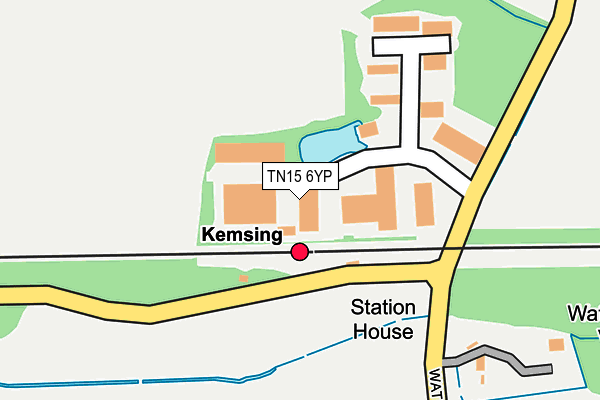
TN15 6YP is located in the Kemsing electoral ward, within the local authority district of Sevenoaks and the English Parliamentary constituency of Sevenoaks. The Sub Integrated Care Board (ICB) Location is NHS Kent and Medway ICB - 91Q and the police force is Kent. This postcode has been in use since December 1997.


GetTheData
Source: OS OpenMap – Local (Ordnance Survey)
Source: OS VectorMap District (Ordnance Survey)
Licence: Open Government Licence (requires attribution)
| Easting | 556767 |
| Northing | 157798 |
| Latitude | 51.297729 |
| Longitude | 0.247211 |
GetTheData
Source: Open Postcode Geo
Licence: Open Government Licence
| Country | England |
| Postcode District | TN15 |
| ➜ TN15 open data dashboard ➜ See where TN15 is on a map | |
GetTheData
Source: Land Registry Price Paid Data
Licence: Open Government Licence
Elevation or altitude of TN15 6YP as distance above sea level:
| Metres | Feet | |
|---|---|---|
| Elevation | 90m | 295ft |
Elevation is measured from the approximate centre of the postcode, to the nearest point on an OS contour line from OS Terrain 50, which has contour spacing of ten vertical metres.
➜ How high above sea level am I? Find the elevation of your current position using your device's GPS.
GetTheData
Source: Open Postcode Elevation
Licence: Open Government Licence
| Ward | Kemsing |
| Constituency | Sevenoaks |
GetTheData
Source: ONS Postcode Database
Licence: Open Government Licence
| June 2022 | Other theft | On or near Parking Area | 82m |
| September 2021 | Drugs | On or near Parking Area | 82m |
| September 2021 | Vehicle crime | On or near Parking Area | 82m |
| ➜ Get more crime data in our Crime section | |||
GetTheData
Source: data.police.uk
Licence: Open Government Licence
| Kemsing Railway Station (Honeypot Lane) | Kemsing | 82m |
| Kemsing Railway Station (Honeypot Lane) | Kemsing | 100m |
| Greenlands Road | Noah's Ark | 1,194m |
| Park Lane (St Ediths Road) | Kemsing | 1,467m |
| Post Office (St Ediths Road) | Kemsing | 1,555m |
| Kemsing Station | 0.1km |
| Bat & Ball Station | 3.8km |
| Otford Station | 3.9km |
GetTheData
Source: NaPTAN
Licence: Open Government Licence
GetTheData
Source: ONS Postcode Database
Licence: Open Government Licence


➜ Get more ratings from the Food Standards Agency
GetTheData
Source: Food Standards Agency
Licence: FSA terms & conditions
| Last Collection | |||
|---|---|---|---|
| Location | Mon-Fri | Sat | Distance |
| Noahs Ark | 16:45 | 10:45 | 1,137m |
| Kemsing Post Office | 17:00 | 10:45 | 1,535m |
| Seal Chart | 16:30 | 09:30 | 1,860m |
GetTheData
Source: Dracos
Licence: Creative Commons Attribution-ShareAlike
| Facility | Distance |
|---|---|
| Common Field Kemsing Heaverham Road, Kemsing, Sevenoaks Grass Pitches, Outdoor Tennis Courts | 1.4km |
| Kemsing Primary School High Street, Kemsing, Sevenoaks Swimming Pool, Grass Pitches | 1.7km |
| Seal Recreation Ground High Street, Seal, Sevenoaks Grass Pitches | 2.2km |
GetTheData
Source: Active Places
Licence: Open Government Licence
| School | Phase of Education | Distance |
|---|---|---|
| Kemsing Primary School West End, Kemsing, Sevenoaks, TN15 6PU | Primary | 1.7km |
| Seal Church of England Voluntary Controlled Primary School Zambra Way, Seal, Sevenoaks, TN15 0DJ | Primary | 2.2km |
| Ightham Primary School Oldbury Lane, Ightham, Sevenoaks, TN15 9DD | Primary | 2.5km |
GetTheData
Source: Edubase
Licence: Open Government Licence
The below table lists the International Territorial Level (ITL) codes (formerly Nomenclature of Territorial Units for Statistics (NUTS) codes) and Local Administrative Units (LAU) codes for TN15 6YP:
| ITL 1 Code | Name |
|---|---|
| TLJ | South East (England) |
| ITL 2 Code | Name |
| TLJ4 | Kent |
| ITL 3 Code | Name |
| TLJ46 | West Kent |
| LAU 1 Code | Name |
| E07000111 | Sevenoaks |
GetTheData
Source: ONS Postcode Directory
Licence: Open Government Licence
The below table lists the Census Output Area (OA), Lower Layer Super Output Area (LSOA), and Middle Layer Super Output Area (MSOA) for TN15 6YP:
| Code | Name | |
|---|---|---|
| OA | E00124101 | |
| LSOA | E01024450 | Sevenoaks 009C |
| MSOA | E02005095 | Sevenoaks 009 |
GetTheData
Source: ONS Postcode Directory
Licence: Open Government Licence
| TN15 6YU | Chaucer Business Park | 47m |
| TN15 6YT | Chaucer Business Park | 47m |
| TN15 6PW | Chaucer Business Park | 67m |
| TN15 6NT | Honey Pot Lane | 82m |
| TN15 6PJ | Chaucer Business Park | 135m |
| TN15 6PL | Chaucer Business Park | 188m |
| TN15 6NS | Waterworks Villas | 291m |
| TN15 0ER | 726m | |
| TN15 6NP | Watery Lane | 858m |
| TN15 6NR | Watery Lane | 960m |
GetTheData
Source: Open Postcode Geo; Land Registry Price Paid Data
Licence: Open Government Licence