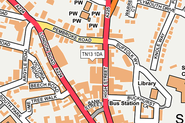
TN13 1DA is located in the Sevenoaks Town and St John's electoral ward, within the local authority district of Sevenoaks and the English Parliamentary constituency of Sevenoaks. The Sub Integrated Care Board (ICB) Location is NHS Kent and Medway ICB - 91Q and the police force is Kent. This postcode has been in use since June 2001.


GetTheData
Source: OS OpenMap – Local (Ordnance Survey)
Source: OS VectorMap District (Ordnance Survey)
Licence: Open Government Licence (requires attribution)
| Easting | 553008 |
| Northing | 154858 |
| Latitude | 51.272334 |
| Longitude | 0.192078 |
GetTheData
Source: Open Postcode Geo
Licence: Open Government Licence
| Country | England |
| Postcode District | TN13 |
| ➜ TN13 open data dashboard ➜ See where TN13 is on a map ➜ Where is Sevenoaks? | |
GetTheData
Source: Land Registry Price Paid Data
Licence: Open Government Licence
Elevation or altitude of TN13 1DA as distance above sea level:
| Metres | Feet | |
|---|---|---|
| Elevation | 140m | 459ft |
Elevation is measured from the approximate centre of the postcode, to the nearest point on an OS contour line from OS Terrain 50, which has contour spacing of ten vertical metres.
➜ How high above sea level am I? Find the elevation of your current position using your device's GPS.
GetTheData
Source: Open Postcode Elevation
Licence: Open Government Licence
| Ward | Sevenoaks Town And St John's |
| Constituency | Sevenoaks |
GetTheData
Source: ONS Postcode Database
Licence: Open Government Licence
| January 2024 | Burglary | On or near Parking Area | 48m |
| January 2024 | Violence and sexual offences | On or near Parking Area | 48m |
| January 2024 | Violence and sexual offences | On or near Parking Area | 48m |
| ➜ Get more crime data in our Crime section | |||
GetTheData
Source: data.police.uk
Licence: Open Government Licence
| M3 House (London Road) | Sevenoaks | 123m |
| M3 House (London Road) | Sevenoaks | 135m |
| Tubs Hill Shops (Pembroke Road) | Sevenoaks | 147m |
| Lower High Street (High Street) | Sevenoaks | 161m |
| Stag Theatre (London Road) | Sevenoaks | 232m |
| Sevenoaks Station | 0.9km |
| Bat & Ball Station | 1.9km |
| Dunton Green Station | 3.1km |
GetTheData
Source: NaPTAN
Licence: Open Government Licence
GetTheData
Source: ONS Postcode Database
Licence: Open Government Licence


➜ Get more ratings from the Food Standards Agency
GetTheData
Source: Food Standards Agency
Licence: FSA terms & conditions
| Last Collection | |||
|---|---|---|---|
| Location | Mon-Fri | Sat | Distance |
| Tesco | 18:45 | 12:30 | 51m |
| Pembroke Road | 18:45 | 12:30 | 62m |
| Youngs | 18:45 | 12:30 | 153m |
GetTheData
Source: Dracos
Licence: Creative Commons Attribution-ShareAlike
| Facility | Distance |
|---|---|
| Sevenoaks Leisure Centre Buckhurst Lane, Sevenoaks Sports Hall, Swimming Pool, Health and Fitness Gym, Studio | 284m |
| Sevenoaks Vine Cricket Club (The Vine Pavilion) Holly Bush Lane, Sevenoaks Grass Pitches | 386m |
| Knole Paddock Plymouth Drive, Sevenoaks Grass Pitches | 483m |
GetTheData
Source: Active Places
Licence: Open Government Licence
| School | Phase of Education | Distance |
|---|---|---|
| Lady Boswell's Church of England Voluntary Aided Primary School, Sevenoaks Plymouth Drive, Sevenoaks, TN13 3RW | Primary | 283m |
| St Thomas' Catholic Primary School, Sevenoaks South Park, Sevenoaks, TN13 1EH | Primary | 322m |
| Sevenoaks School High Street, Sevenoaks, Kent, Sevenoaks, TN13 1HU | Not applicable | 786m |
GetTheData
Source: Edubase
Licence: Open Government Licence
The below table lists the International Territorial Level (ITL) codes (formerly Nomenclature of Territorial Units for Statistics (NUTS) codes) and Local Administrative Units (LAU) codes for TN13 1DA:
| ITL 1 Code | Name |
|---|---|
| TLJ | South East (England) |
| ITL 2 Code | Name |
| TLJ4 | Kent |
| ITL 3 Code | Name |
| TLJ46 | West Kent |
| LAU 1 Code | Name |
| E07000111 | Sevenoaks |
GetTheData
Source: ONS Postcode Directory
Licence: Open Government Licence
The below table lists the Census Output Area (OA), Lower Layer Super Output Area (LSOA), and Middle Layer Super Output Area (MSOA) for TN13 1DA:
| Code | Name | |
|---|---|---|
| OA | E00124204 | |
| LSOA | E01024469 | Sevenoaks 012D |
| MSOA | E02005098 | Sevenoaks 012 |
GetTheData
Source: ONS Postcode Directory
Licence: Open Government Licence
| TN13 1UY | High Street | 53m |
| TN13 1XE | High Street | 72m |
| TN13 1UP | High Street | 82m |
| TN13 1DS | Blacks Yard | 109m |
| TN13 1YL | Suffolk Way | 111m |
| TN13 1AS | London Road | 115m |
| TN13 1YW | Pembroke Mews | 117m |
| TN13 1XJ | High Street | 119m |
| TN13 1XR | Pembroke Road | 126m |
| TN13 1AU | London Road | 128m |
GetTheData
Source: Open Postcode Geo; Land Registry Price Paid Data
Licence: Open Government Licence