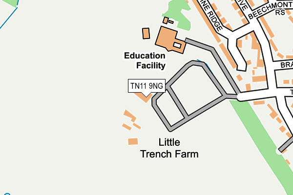
TN11 9NG is located in the Hildenborough electoral ward, within the local authority district of Tonbridge and Malling and the English Parliamentary constituency of Tonbridge and Malling. The Sub Integrated Care Board (ICB) Location is NHS Kent and Medway ICB - 91Q and the police force is Kent. This postcode has been in use since January 1980.


GetTheData
Source: OS OpenMap – Local (Ordnance Survey)
Source: OS VectorMap District (Ordnance Survey)
Licence: Open Government Licence (requires attribution)
| Easting | 558632 |
| Northing | 148756 |
| Latitude | 51.215973 |
| Longitude | 0.269934 |
GetTheData
Source: Open Postcode Geo
Licence: Open Government Licence
| Country | England |
| Postcode District | TN11 |
| ➜ TN11 open data dashboard ➜ See where TN11 is on a map | |
GetTheData
Source: Land Registry Price Paid Data
Licence: Open Government Licence
Elevation or altitude of TN11 9NG as distance above sea level:
| Metres | Feet | |
|---|---|---|
| Elevation | 40m | 131ft |
Elevation is measured from the approximate centre of the postcode, to the nearest point on an OS contour line from OS Terrain 50, which has contour spacing of ten vertical metres.
➜ How high above sea level am I? Find the elevation of your current position using your device's GPS.
GetTheData
Source: Open Postcode Elevation
Licence: Open Government Licence
| Ward | Hildenborough |
| Constituency | Tonbridge And Malling |
GetTheData
Source: ONS Postcode Database
Licence: Open Government Licence
| January 2024 | Criminal damage and arson | On or near Bracken Walk | 316m |
| December 2023 | Violence and sexual offences | On or near Bracken Walk | 316m |
| October 2023 | Violence and sexual offences | On or near Bracken Walk | 316m |
| ➜ Get more crime data in our Crime section | |||
GetTheData
Source: data.police.uk
Licence: Open Government Licence
| St Margaret Clitherow School (School Grounds) | Trench Wood | 149m |
| Greenfrith Drive (Trench Road) | Trench Wood | 289m |
| Heather Walk (Beechmont Rise) | Trench Wood | 310m |
| Heather Walk (Beechmont Rise) | Trench Wood | 326m |
| Greenfrith Drive (Trench Road) | Trench Wood | 333m |
| Tonbridge Station | 2.7km |
| Hildenborough Station | 3km |
| Leigh (Kent) Station | 4.8km |
GetTheData
Source: NaPTAN
Licence: Open Government Licence
| Percentage of properties with Next Generation Access | 100.0% |
| Percentage of properties with Superfast Broadband | 100.0% |
| Percentage of properties with Ultrafast Broadband | 0.0% |
| Percentage of properties with Full Fibre Broadband | 0.0% |
Superfast Broadband is between 30Mbps and 300Mbps
Ultrafast Broadband is > 300Mbps
| Percentage of properties unable to receive 2Mbps | 0.0% |
| Percentage of properties unable to receive 5Mbps | 0.0% |
| Percentage of properties unable to receive 10Mbps | 0.0% |
| Percentage of properties unable to receive 30Mbps | 0.0% |
GetTheData
Source: Ofcom
Licence: Ofcom Terms of Use (requires attribution)
GetTheData
Source: ONS Postcode Database
Licence: Open Government Licence


➜ Get more ratings from the Food Standards Agency
GetTheData
Source: Food Standards Agency
Licence: FSA terms & conditions
| Last Collection | |||
|---|---|---|---|
| Location | Mon-Fri | Sat | Distance |
| Trench Road | 17:30 | 12:30 | 549m |
| Hamble Road / Waveney Road | 17:30 | 12:30 | 587m |
| York Parade Post Office | 17:15 | 12:00 | 794m |
GetTheData
Source: Dracos
Licence: Creative Commons Attribution-ShareAlike
| Facility | Distance |
|---|---|
| The Halcyon Wealth Longmead Stadium Darenth Avenue, Tonbridge Grass Pitches, Artificial Grass Pitch | 498m |
| Tonbridge Farm Darenth Avenue, Tonbridge Grass Pitches, Artificial Grass Pitch | 670m |
| Tonbridge Cricket Club Welland Road, Tonbridge Grass Pitches | 1km |
GetTheData
Source: Active Places
Licence: Open Government Licence
| School | Phase of Education | Distance |
|---|---|---|
| St Margaret Clitherow Catholic Primary School Trench Road, Tonbridge, TN11 9NG | Primary | 123m |
| Long Mead Community Primary School Waveney Road, Tonbridge, TN10 3JU | Primary | 335m |
| Hugh Christie School White Cottage Road, Tonbridge, TN10 4PU | Secondary | 842m |
GetTheData
Source: Edubase
Licence: Open Government Licence
The below table lists the International Territorial Level (ITL) codes (formerly Nomenclature of Territorial Units for Statistics (NUTS) codes) and Local Administrative Units (LAU) codes for TN11 9NG:
| ITL 1 Code | Name |
|---|---|
| TLJ | South East (England) |
| ITL 2 Code | Name |
| TLJ4 | Kent |
| ITL 3 Code | Name |
| TLJ46 | West Kent |
| LAU 1 Code | Name |
| E07000115 | Tonbridge and Malling |
GetTheData
Source: ONS Postcode Directory
Licence: Open Government Licence
The below table lists the Census Output Area (OA), Lower Layer Super Output Area (LSOA), and Middle Layer Super Output Area (MSOA) for TN11 9NG:
| Code | Name | |
|---|---|---|
| OA | E00125641 | |
| LSOA | E01024754 | Tonbridge and Malling 010D |
| MSOA | E02005158 | Tonbridge and Malling 010 |
GetTheData
Source: ONS Postcode Directory
Licence: Open Government Licence
| TN10 3LL | Pine Ridge | 196m |
| TN10 3LN | Pine Ridge | 230m |
| TN10 3LG | Greenfrith Drive | 280m |
| TN10 3LQ | Greenfrith Drive | 293m |
| TN10 3HJ | Northwood Road | 324m |
| TN10 3LF | Bracken Walk | 341m |
| TN10 3NU | Bishops Oak Ride | 342m |
| TN10 3HG | Trench Road | 350m |
| TN10 3NA | Heather Walk | 355m |
| TN10 3NX | Bishops Oak Ride | 361m |
GetTheData
Source: Open Postcode Geo; Land Registry Price Paid Data
Licence: Open Government Licence