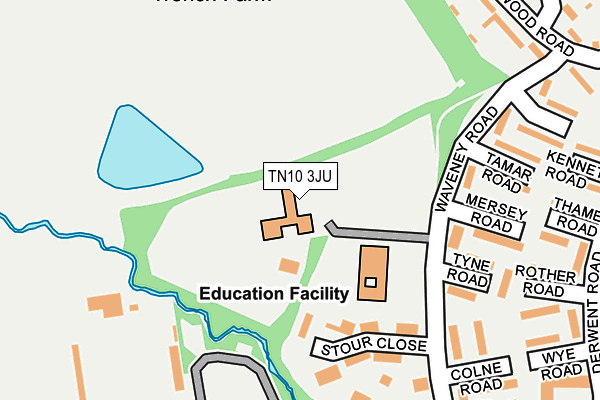
TN10 3JU is located in the Trench electoral ward, within the local authority district of Tonbridge and Malling and the English Parliamentary constituency of Tonbridge and Malling. The Sub Integrated Care Board (ICB) Location is NHS Kent and Medway ICB - 91Q and the police force is Kent. This postcode has been in use since January 1980.


GetTheData
Source: OS OpenMap – Local (Ordnance Survey)
Source: OS VectorMap District (Ordnance Survey)
Licence: Open Government Licence (requires attribution)
| Easting | 558757 |
| Northing | 148366 |
| Latitude | 51.212432 |
| Longitude | 0.271577 |
GetTheData
Source: Open Postcode Geo
Licence: Open Government Licence
| Country | England |
| Postcode District | TN10 |
| ➜ TN10 open data dashboard ➜ See where TN10 is on a map ➜ Where is Tonbridge? | |
GetTheData
Source: Land Registry Price Paid Data
Licence: Open Government Licence
Elevation or altitude of TN10 3JU as distance above sea level:
| Metres | Feet | |
|---|---|---|
| Elevation | 30m | 98ft |
Elevation is measured from the approximate centre of the postcode, to the nearest point on an OS contour line from OS Terrain 50, which has contour spacing of ten vertical metres.
➜ How high above sea level am I? Find the elevation of your current position using your device's GPS.
GetTheData
Source: Open Postcode Elevation
Licence: Open Government Licence
| Ward | Trench |
| Constituency | Tonbridge And Malling |
GetTheData
Source: ONS Postcode Database
Licence: Open Government Licence
| January 2024 | Criminal damage and arson | On or near Thames Road | 287m |
| January 2024 | Criminal damage and arson | On or near Bracken Walk | 497m |
| December 2023 | Violence and sexual offences | On or near Hamble Road | 199m |
| ➜ Get more crime data in our Crime section | |||
GetTheData
Source: data.police.uk
Licence: Open Government Licence
| Tyne Road (Waveney Road) | Trench Wood | 161m |
| Mersey Road (Waveney Road) | Trench Wood | 170m |
| Hamble Road (Waveney Road) | Trench Wood | 220m |
| Waveney Road (Darenth Avenue) | Trench Wood | 303m |
| Derwent Road (Darenth Avenue) | Trench Wood | 360m |
| Tonbridge Station | 2.3km |
| Hildenborough Station | 3.1km |
| Leigh (Kent) Station | 4.7km |
GetTheData
Source: NaPTAN
Licence: Open Government Licence
GetTheData
Source: ONS Postcode Database
Licence: Open Government Licence


➜ Get more ratings from the Food Standards Agency
GetTheData
Source: Food Standards Agency
Licence: FSA terms & conditions
| Last Collection | |||
|---|---|---|---|
| Location | Mon-Fri | Sat | Distance |
| Hamble Road / Waveney Road | 17:30 | 12:30 | 195m |
| Trench Road | 17:30 | 12:30 | 499m |
| Cage Green Road | 17:15 | 12:15 | 582m |
GetTheData
Source: Dracos
Licence: Creative Commons Attribution-ShareAlike
| Facility | Distance |
|---|---|
| The Halcyon Wealth Longmead Stadium Darenth Avenue, Tonbridge Grass Pitches, Artificial Grass Pitch | 198m |
| Tonbridge Farm Darenth Avenue, Tonbridge Grass Pitches, Artificial Grass Pitch | 295m |
| Tonbridge Cricket Club Welland Road, Tonbridge Grass Pitches | 644m |
GetTheData
Source: Active Places
Licence: Open Government Licence
| School | Phase of Education | Distance |
|---|---|---|
| Long Mead Community Primary School Waveney Road, Tonbridge, TN10 3JU | Primary | 78m |
| St Margaret Clitherow Catholic Primary School Trench Road, Tonbridge, TN11 9NG | Primary | 510m |
| YMCA West Kent 164 Shipbourne Road, Tonbridge, TN10 3EJ | Not applicable | 699m |
GetTheData
Source: Edubase
Licence: Open Government Licence
The below table lists the International Territorial Level (ITL) codes (formerly Nomenclature of Territorial Units for Statistics (NUTS) codes) and Local Administrative Units (LAU) codes for TN10 3JU:
| ITL 1 Code | Name |
|---|---|
| TLJ | South East (England) |
| ITL 2 Code | Name |
| TLJ4 | Kent |
| ITL 3 Code | Name |
| TLJ46 | West Kent |
| LAU 1 Code | Name |
| E07000115 | Tonbridge and Malling |
GetTheData
Source: ONS Postcode Directory
Licence: Open Government Licence
The below table lists the Census Output Area (OA), Lower Layer Super Output Area (LSOA), and Middle Layer Super Output Area (MSOA) for TN10 3JU:
| Code | Name | |
|---|---|---|
| OA | E00125754 | |
| LSOA | E01024775 | Tonbridge and Malling 009C |
| MSOA | E02005157 | Tonbridge and Malling 009 |
GetTheData
Source: ONS Postcode Directory
Licence: Open Government Licence
| TN10 3LE | Stour Close | 86m |
| TN10 3JY | Waveney Road | 170m |
| TN10 3JL | Hamble Road | 178m |
| TN10 3JZ | Waveney Road | 199m |
| TN10 3JP | Tyne Road | 199m |
| TN10 3JN | Colne Road | 202m |
| TN10 3JR | Mersey Road | 203m |
| TN10 3JH | Rother Road | 258m |
| TN10 3LA | Waveney Road | 259m |
| TN10 3JS | Tamar Road | 260m |
GetTheData
Source: Open Postcode Geo; Land Registry Price Paid Data
Licence: Open Government Licence