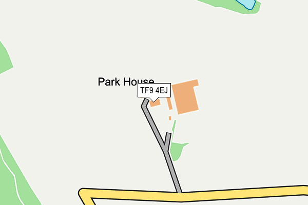
TF9 4EJ is located in the Loggerheads electoral ward, within the local authority district of Newcastle-under-Lyme and the English Parliamentary constituency of Stone. The Sub Integrated Care Board (ICB) Location is NHS Staffordshire and Stoke-on-Trent ICB - 05G and the police force is Staffordshire. This postcode has been in use since January 1980.


GetTheData
Source: OS OpenMap – Local (Ordnance Survey)
Source: OS VectorMap District (Ordnance Survey)
Licence: Open Government Licence (requires attribution)
| Easting | 376284 |
| Northing | 338519 |
| Latitude | 52.943546 |
| Longitude | -2.354364 |
GetTheData
Source: Open Postcode Geo
Licence: Open Government Licence
| Country | England |
| Postcode District | TF9 |
| ➜ TF9 open data dashboard ➜ See where TF9 is on a map | |
GetTheData
Source: Land Registry Price Paid Data
Licence: Open Government Licence
Elevation or altitude of TF9 4EJ as distance above sea level:
| Metres | Feet | |
|---|---|---|
| Elevation | 120m | 394ft |
Elevation is measured from the approximate centre of the postcode, to the nearest point on an OS contour line from OS Terrain 50, which has contour spacing of ten vertical metres.
➜ How high above sea level am I? Find the elevation of your current position using your device's GPS.
GetTheData
Source: Open Postcode Elevation
Licence: Open Government Licence
| Ward | Loggerheads |
| Constituency | Stone |
GetTheData
Source: ONS Postcode Database
Licence: Open Government Licence
| Hungers Heath Farm (Hungers Heath Lane) | Blackbrook | 202m |
| The Croft (Maerway Lane) | Blackbrook | 520m |
| The Croft (Maerway Lane) | Blackbrook | 536m |
| Newcastle Road (Nantwich Road) | Blackbrook | 874m |
| Nantwich Road (Newcastle Road) | Blackbrook | 906m |
GetTheData
Source: NaPTAN
Licence: Open Government Licence
GetTheData
Source: ONS Postcode Database
Licence: Open Government Licence


➜ Get more ratings from the Food Standards Agency
GetTheData
Source: Food Standards Agency
Licence: FSA terms & conditions
| Last Collection | |||
|---|---|---|---|
| Location | Mon-Fri | Sat | Distance |
| Gravenhunger | 16:30 | 09:00 | 4,625m |
GetTheData
Source: Dracos
Licence: Creative Commons Attribution-ShareAlike
| Facility | Distance |
|---|---|
| The Burntwood Eccleshall Road, Loggerheads, Newcastle Under Lyme Grass Pitches | 4.1km |
| Onneley Golf Club Bar Hill Road, Onneley, Crewe Golf | 4.9km |
| Falcon Field London Road, Woore Grass Pitches | 4.9km |
GetTheData
Source: Active Places
Licence: Open Government Licence
| School | Phase of Education | Distance |
|---|---|---|
| Hugo Meynell CofE (VC) Primary School Eccleshall Road, Loggerheads, Market Drayton, TF9 4NU | Primary | 3.5km |
| Baldwins Gate CofE(VC) Primary School Tollgate Avenue, Baldwins Gate, Newcastle-Under-Lyme, ST5 5DF | Primary | 3.7km |
| St Mary's CofE (A) Primary School Mucklestone, Market Drayton, TF9 4DN | Primary | 4.1km |
GetTheData
Source: Edubase
Licence: Open Government Licence
The below table lists the International Territorial Level (ITL) codes (formerly Nomenclature of Territorial Units for Statistics (NUTS) codes) and Local Administrative Units (LAU) codes for TF9 4EJ:
| ITL 1 Code | Name |
|---|---|
| TLG | West Midlands (England) |
| ITL 2 Code | Name |
| TLG2 | Shropshire and Staffordshire |
| ITL 3 Code | Name |
| TLG24 | Staffordshire CC |
| LAU 1 Code | Name |
| E07000195 | Newcastle-under-Lyme |
GetTheData
Source: ONS Postcode Directory
Licence: Open Government Licence
The below table lists the Census Output Area (OA), Lower Layer Super Output Area (LSOA), and Middle Layer Super Output Area (MSOA) for TF9 4EJ:
| Code | Name | |
|---|---|---|
| OA | E00150678 | |
| LSOA | E01029569 | Newcastle-under-Lyme 016A |
| MSOA | E02006173 | Newcastle-under-Lyme 016 |
GetTheData
Source: ONS Postcode Directory
Licence: Open Government Licence
| ST5 5EL | The Croft | 466m |
| ST5 5EH | Nantwich Road | 597m |
| ST5 5EJ | Wood Lane | 991m |
| TF9 4ET | 1094m | |
| TF9 4NB | Newcastle Road | 1384m |
| ST5 5EG | Stone Road | 1406m |
| TF9 4NE | Elder Tree Lane | 1419m |
| TF9 4ND | Sandy Lane | 1440m |
| TF9 4NA | Top Rock Road | 1466m |
| ST5 5EN | Maerway Lane | 1489m |
GetTheData
Source: Open Postcode Geo; Land Registry Price Paid Data
Licence: Open Government Licence