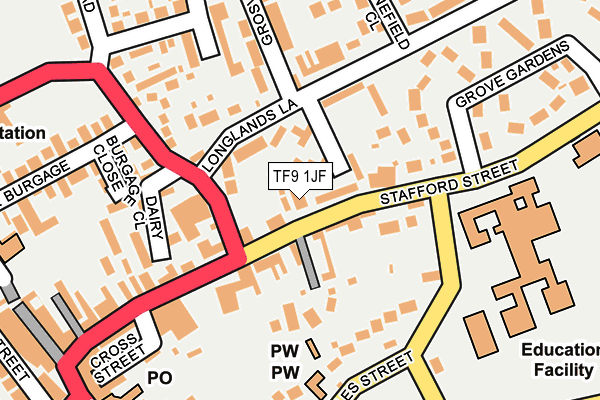
TF9 1JF is located in the Market Drayton East electoral ward, within the unitary authority of Shropshire and the English Parliamentary constituency of North Shropshire. The Sub Integrated Care Board (ICB) Location is NHS Shropshire, Telford and Wrekin ICB - M2L0M and the police force is West Mercia. This postcode has been in use since January 1980.


GetTheData
Source: OS OpenMap – Local (Ordnance Survey)
Source: OS VectorMap District (Ordnance Survey)
Licence: Open Government Licence (requires attribution)
| Easting | 367783 |
| Northing | 334370 |
| Latitude | 52.905790 |
| Longitude | -2.480450 |
GetTheData
Source: Open Postcode Geo
Licence: Open Government Licence
| Country | England |
| Postcode District | TF9 |
| ➜ TF9 open data dashboard ➜ See where TF9 is on a map ➜ Where is Market Drayton? | |
GetTheData
Source: Land Registry Price Paid Data
Licence: Open Government Licence
Elevation or altitude of TF9 1JF as distance above sea level:
| Metres | Feet | |
|---|---|---|
| Elevation | 90m | 295ft |
Elevation is measured from the approximate centre of the postcode, to the nearest point on an OS contour line from OS Terrain 50, which has contour spacing of ten vertical metres.
➜ How high above sea level am I? Find the elevation of your current position using your device's GPS.
GetTheData
Source: Open Postcode Elevation
Licence: Open Government Licence
| Ward | Market Drayton East |
| Constituency | North Shropshire |
GetTheData
Source: ONS Postcode Database
Licence: Open Government Licence
| January 2024 | Other theft | On or near Grosvenor Road | 189m |
| December 2023 | Shoplifting | On or near Parking Area | 245m |
| November 2023 | Criminal damage and arson | On or near Parking Area | 245m |
| ➜ Get more crime data in our Crime section | |||
GetTheData
Source: data.police.uk
Licence: Open Government Licence
| No. 53 (Longlands Lane) | Market Drayton | 212m |
| Grove School (Stafford Street) | Market Drayton | 286m |
| Grove School (Stafford Street) | Market Drayton | 289m |
| Stafford Street Jct (High Street) | Market Drayton | 295m |
| Iceland (Cheshire Street) | Market Drayton | 335m |
GetTheData
Source: NaPTAN
Licence: Open Government Licence
GetTheData
Source: ONS Postcode Database
Licence: Open Government Licence


➜ Get more ratings from the Food Standards Agency
GetTheData
Source: Food Standards Agency
Licence: FSA terms & conditions
| Last Collection | |||
|---|---|---|---|
| Location | Mon-Fri | Sat | Distance |
| Fairfields | 17:15 | 11:30 | 513m |
| Peatswood | 11:00 | 11:00 | 1,604m |
| Betton | 16:00 | 11:15 | 2,641m |
GetTheData
Source: Dracos
Licence: Creative Commons Attribution-ShareAlike
| Facility | Distance |
|---|---|
| The Grove School Stafford Street, Market Drayton Grass Pitches, Sports Hall | 209m |
| Longlands Community Primary School Linden Way, Market Drayton Grass Pitches | 308m |
| The Zone Community Hub Linden Way, Market Drayton Grass Pitches | 422m |
GetTheData
Source: Active Places
Licence: Open Government Licence
| School | Phase of Education | Distance |
|---|---|---|
| The Grove School Newcastle Road, Market Drayton, TF9 1HF | Secondary | 209m |
| Longlands Primary School Linden Way, Fairfields, Market Drayton, TF9 1QU | Primary | 305m |
| Market Drayton Infant & Nursery School Longslow Road, Market Drayton, TF9 3BA | Primary | 665m |
GetTheData
Source: Edubase
Licence: Open Government Licence
The below table lists the International Territorial Level (ITL) codes (formerly Nomenclature of Territorial Units for Statistics (NUTS) codes) and Local Administrative Units (LAU) codes for TF9 1JF:
| ITL 1 Code | Name |
|---|---|
| TLG | West Midlands (England) |
| ITL 2 Code | Name |
| TLG2 | Shropshire and Staffordshire |
| ITL 3 Code | Name |
| TLG22 | Shropshire |
| LAU 1 Code | Name |
| E06000051 | Shropshire |
GetTheData
Source: ONS Postcode Directory
Licence: Open Government Licence
The below table lists the Census Output Area (OA), Lower Layer Super Output Area (LSOA), and Middle Layer Super Output Area (MSOA) for TF9 1JF:
| Code | Name | |
|---|---|---|
| OA | E00147048 | |
| LSOA | E01028873 | Shropshire 005A |
| MSOA | E02006018 | Shropshire 005 |
GetTheData
Source: ONS Postcode Directory
Licence: Open Government Licence
| TF9 1JQ | Stafford Street | 38m |
| TF9 1JB | Stafford Street | 53m |
| TF9 1JD | Stafford Street | 64m |
| TF9 1ES | Longlands Lane | 66m |
| TF9 1EZ | Barrow Styles Lane | 107m |
| TF9 1EP | Smithfield Road | 112m |
| TF9 1ER | Longlands Lane | 112m |
| TF9 1EY | Longlands Lane | 119m |
| TF9 1HD | Longlands Lane | 153m |
| TF9 1EW | Smithfield Road | 165m |
GetTheData
Source: Open Postcode Geo; Land Registry Price Paid Data
Licence: Open Government Licence