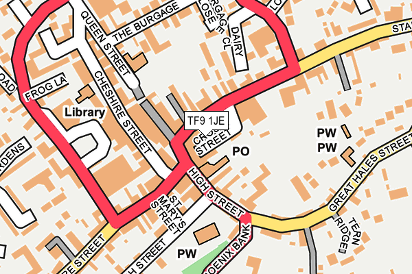
TF9 1JE is located in the Market Drayton East electoral ward, within the unitary authority of Shropshire and the English Parliamentary constituency of North Shropshire. The Sub Integrated Care Board (ICB) Location is NHS Shropshire, Telford and Wrekin ICB - M2L0M and the police force is West Mercia. This postcode has been in use since February 2006.


GetTheData
Source: OS OpenMap – Local (Ordnance Survey)
Source: OS VectorMap District (Ordnance Survey)
Licence: Open Government Licence (requires attribution)
| Easting | 367596 |
| Northing | 334211 |
| Latitude | 52.904365 |
| Longitude | -2.483214 |
GetTheData
Source: Open Postcode Geo
Licence: Open Government Licence
| Country | England |
| Postcode District | TF9 |
| ➜ TF9 open data dashboard ➜ See where TF9 is on a map ➜ Where is Market Drayton? | |
GetTheData
Source: Land Registry Price Paid Data
Licence: Open Government Licence
Elevation or altitude of TF9 1JE as distance above sea level:
| Metres | Feet | |
|---|---|---|
| Elevation | 90m | 295ft |
Elevation is measured from the approximate centre of the postcode, to the nearest point on an OS contour line from OS Terrain 50, which has contour spacing of ten vertical metres.
➜ How high above sea level am I? Find the elevation of your current position using your device's GPS.
GetTheData
Source: Open Postcode Elevation
Licence: Open Government Licence
| Ward | Market Drayton East |
| Constituency | North Shropshire |
GetTheData
Source: ONS Postcode Database
Licence: Open Government Licence
| January 2024 | Other theft | On or near Grosvenor Road | 372m |
| December 2023 | Shoplifting | On or near Parking Area | 115m |
| November 2023 | Criminal damage and arson | On or near Parking Area | 115m |
| ➜ Get more crime data in our Crime section | |||
GetTheData
Source: data.police.uk
Licence: Open Government Licence
| Stafford Street Jct (High Street) | Market Drayton | 53m |
| Iceland (Cheshire Street) | Market Drayton | 138m |
| Iceland (Cheshire Street) | Market Drayton | 150m |
| Bus Station | Market Drayton | 304m |
| Bus Station | Market Drayton | 306m |
GetTheData
Source: NaPTAN
Licence: Open Government Licence
| Median download speed | 24.3Mbps |
| Average download speed | 28.9Mbps |
| Maximum download speed | 40.00Mbps |
| Median upload speed | 1.3Mbps |
| Average upload speed | 4.7Mbps |
| Maximum upload speed | 10.00Mbps |
GetTheData
Source: Ofcom
Licence: Ofcom Terms of Use (requires attribution)
Estimated total energy consumption in TF9 1JE by fuel type, 2015.
| Consumption (kWh) | 23,744 |
|---|---|
| Meter count | 8 |
| Mean (kWh/meter) | 2,968 |
| Median (kWh/meter) | 1,969 |
GetTheData
Source: Postcode level gas estimates: 2015 (experimental)
Source: Postcode level electricity estimates: 2015 (experimental)
Licence: Open Government Licence
GetTheData
Source: ONS Postcode Database
Licence: Open Government Licence


➜ Get more ratings from the Food Standards Agency
GetTheData
Source: Food Standards Agency
Licence: FSA terms & conditions
| Last Collection | |||
|---|---|---|---|
| Location | Mon-Fri | Sat | Distance |
| Fairfields | 17:15 | 11:30 | 684m |
| Peatswood | 11:00 | 11:00 | 1,732m |
| Betton | 16:00 | 11:15 | 2,873m |
GetTheData
Source: Dracos
Licence: Creative Commons Attribution-ShareAlike
| Facility | Distance |
|---|---|
| Market Drayton Swimming & Fitness Centre Newtown, Market Drayton Swimming Pool, Health and Fitness Gym | 411m |
| The Grove School Stafford Street, Market Drayton Grass Pitches, Sports Hall | 426m |
| Bodytech Health Club (Market Drayton) (Closed) Cheshire Street, Market Drayton Health and Fitness Gym, Studio | 474m |
GetTheData
Source: Active Places
Licence: Open Government Licence
| School | Phase of Education | Distance |
|---|---|---|
| The Grove School Newcastle Road, Market Drayton, TF9 1HF | Secondary | 426m |
| Market Drayton Infant & Nursery School Longslow Road, Market Drayton, TF9 3BA | Primary | 442m |
| Longlands Primary School Linden Way, Fairfields, Market Drayton, TF9 1QU | Primary | 532m |
GetTheData
Source: Edubase
Licence: Open Government Licence
The below table lists the International Territorial Level (ITL) codes (formerly Nomenclature of Territorial Units for Statistics (NUTS) codes) and Local Administrative Units (LAU) codes for TF9 1JE:
| ITL 1 Code | Name |
|---|---|
| TLG | West Midlands (England) |
| ITL 2 Code | Name |
| TLG2 | Shropshire and Staffordshire |
| ITL 3 Code | Name |
| TLG22 | Shropshire |
| LAU 1 Code | Name |
| E06000051 | Shropshire |
GetTheData
Source: ONS Postcode Directory
Licence: Open Government Licence
The below table lists the Census Output Area (OA), Lower Layer Super Output Area (LSOA), and Middle Layer Super Output Area (MSOA) for TF9 1JE:
| Code | Name | |
|---|---|---|
| OA | E00147050 | |
| LSOA | E01028873 | Shropshire 005A |
| MSOA | E02006018 | Shropshire 005 |
GetTheData
Source: ONS Postcode Directory
Licence: Open Government Licence
| TF9 1HY | Stafford Street | 35m |
| TF9 1JA | Cross Street | 37m |
| TF9 1PY | High Street | 52m |
| TF9 1HX | Stafford Street | 72m |
| TF9 1QB | High Street | 75m |
| TF9 1PX | Queen Street | 79m |
| TF9 1PD | Cheshire Street | 89m |
| TF9 3BZ | Shropshire Street | 90m |
| TF9 1PF | Cheshire Street | 93m |
| TF9 1RA | Salopian Court | 97m |
GetTheData
Source: Open Postcode Geo; Land Registry Price Paid Data
Licence: Open Government Licence