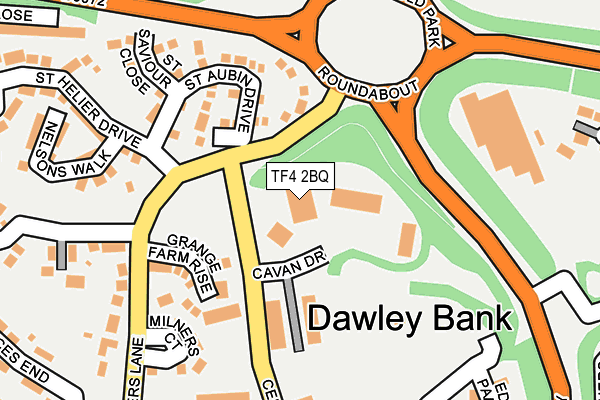
TF4 2BQ is located in the Malinslee & Dawley Bank electoral ward, within the unitary authority of Telford and Wrekin and the English Parliamentary constituency of Telford. The Sub Integrated Care Board (ICB) Location is NHS Shropshire, Telford and Wrekin ICB - M2L0M and the police force is West Mercia. This postcode has been in use since February 1984.


GetTheData
Source: OS OpenMap – Local (Ordnance Survey)
Source: OS VectorMap District (Ordnance Survey)
Licence: Open Government Licence (requires attribution)
| Easting | 368437 |
| Northing | 308811 |
| Latitude | 52.676075 |
| Longitude | -2.468252 |
GetTheData
Source: Open Postcode Geo
Licence: Open Government Licence
| Country | England |
| Postcode District | TF4 |
| ➜ TF4 open data dashboard ➜ See where TF4 is on a map ➜ Where is Telford? | |
GetTheData
Source: Land Registry Price Paid Data
Licence: Open Government Licence
Elevation or altitude of TF4 2BQ as distance above sea level:
| Metres | Feet | |
|---|---|---|
| Elevation | 200m | 656ft |
Elevation is measured from the approximate centre of the postcode, to the nearest point on an OS contour line from OS Terrain 50, which has contour spacing of ten vertical metres.
➜ How high above sea level am I? Find the elevation of your current position using your device's GPS.
GetTheData
Source: Open Postcode Elevation
Licence: Open Government Licence
| Ward | Malinslee & Dawley Bank |
| Constituency | Telford |
GetTheData
Source: ONS Postcode Database
Licence: Open Government Licence
| November 2023 | Violence and sexual offences | On or near St Davids Close | 477m |
| September 2023 | Criminal damage and arson | On or near St Davids Close | 477m |
| August 2023 | Violence and sexual offences | On or near St Davids Close | 477m |
| ➜ Get more crime data in our Crime section | |||
GetTheData
Source: data.police.uk
Licence: Open Government Licence
| St Aubin Drive (Milners Lane) | Dawley Bank | 59m |
| St Aubin Drive (Milners Lane) | Dawley Bank | 76m |
| Wrekin View (Milners Lane) | Dawley Bank | 298m |
| Teawell Close (Rock Road) | Overdale | 298m |
| Wrekin View (Milners Lane) | Dawley Bank | 303m |
| Telford Central Station | 1.9km |
| Oakengates Station | 2.3km |
| Wellington (Shropshire) Station | 4.3km |
GetTheData
Source: NaPTAN
Licence: Open Government Licence
GetTheData
Source: ONS Postcode Database
Licence: Open Government Licence


➜ Get more ratings from the Food Standards Agency
GetTheData
Source: Food Standards Agency
Licence: FSA terms & conditions
| Last Collection | |||
|---|---|---|---|
| Location | Mon-Fri | Sat | Distance |
| Lawley | 17:30 | 11:00 | 364m |
| The Rock | 14:45 | 11:30 | 679m |
| Bellpitt Road | 17:30 | 11:00 | 774m |
GetTheData
Source: Dracos
Licence: Creative Commons Attribution-ShareAlike
| Facility | Distance |
|---|---|
| Malinslee Playing Fields Alma Avenue, Dawley, Telford Grass Pitches, Cycling | 544m |
| Ladygrove Primary School Old Office Road, Dawley, Telford Grass Pitches | 580m |
| Thomas Telford School Old Park, Telford Swimming Pool, Artificial Grass Pitch, Sports Hall, Health and Fitness Gym, Grass Pitches, Studio, Outdoor Tennis Courts | 702m |
GetTheData
Source: Active Places
Licence: Open Government Licence
| School | Phase of Education | Distance |
|---|---|---|
| Thomas Telford School Old Park, Telford, TF3 4NW | Not applicable | 696m |
| Ladygrove Primary School Old Office Road, Dawley, Telford, TF4 2LF | Primary | 777m |
| Lawley Village Academy Bryce Way, Lawley Village, Telford, TF4 2SG | Primary | 867m |
GetTheData
Source: Edubase
Licence: Open Government Licence
The below table lists the International Territorial Level (ITL) codes (formerly Nomenclature of Territorial Units for Statistics (NUTS) codes) and Local Administrative Units (LAU) codes for TF4 2BQ:
| ITL 1 Code | Name |
|---|---|
| TLG | West Midlands (England) |
| ITL 2 Code | Name |
| TLG2 | Shropshire and Staffordshire |
| ITL 3 Code | Name |
| TLG21 | Telford and Wrekin |
| LAU 1 Code | Name |
| E06000020 | Telford and Wrekin |
GetTheData
Source: ONS Postcode Directory
Licence: Open Government Licence
The below table lists the Census Output Area (OA), Lower Layer Super Output Area (LSOA), and Middle Layer Super Output Area (MSOA) for TF4 2BQ:
| Code | Name | |
|---|---|---|
| OA | E00071496 | |
| LSOA | E01014158 | Telford and Wrekin 016E |
| MSOA | E02002943 | Telford and Wrekin 016 |
GetTheData
Source: ONS Postcode Directory
Licence: Open Government Licence
| TF4 2GZ | St Brelade Close | 126m |
| TF4 2EZ | Grange Farm Rise | 138m |
| TF4 2GY | St Aubin Drive | 139m |
| TF4 2JS | Milners Court | 180m |
| TF4 2GX | St Saviour Close | 211m |
| TF4 2JL | Princes End | 215m |
| TF4 2JJ | Milners Lane | 225m |
| TF4 2QE | Hill Fold | 239m |
| TF4 2FN | Nelsons Walk | 247m |
| TF4 2JH | Milners Lane | 280m |
GetTheData
Source: Open Postcode Geo; Land Registry Price Paid Data
Licence: Open Government Licence