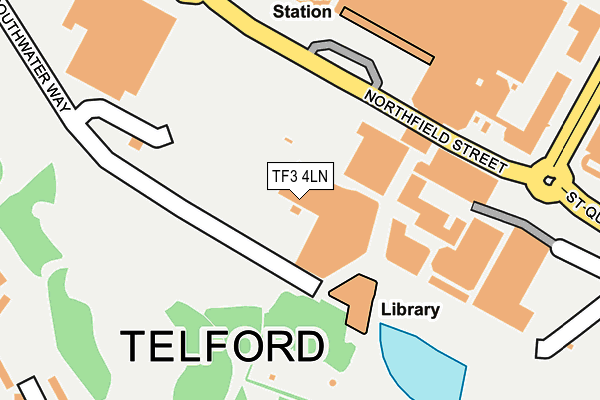
TF3 4LN is located in the Malinslee & Dawley Bank electoral ward, within the unitary authority of Telford and Wrekin and the English Parliamentary constituency of Telford. The Sub Integrated Care Board (ICB) Location is NHS Shropshire, Telford and Wrekin ICB - M2L0M and the police force is West Mercia. This postcode has been in use since August 1993.


GetTheData
Source: OS OpenMap – Local (Ordnance Survey)
Source: OS VectorMap District (Ordnance Survey)
Licence: Open Government Licence (requires attribution)
| Easting | 369738 |
| Northing | 308596 |
| Latitude | 52.674217 |
| Longitude | -2.448991 |
GetTheData
Source: Open Postcode Geo
Licence: Open Government Licence
| Country | England |
| Postcode District | TF3 |
| ➜ TF3 open data dashboard ➜ See where TF3 is on a map ➜ Where is Telford? | |
GetTheData
Source: Land Registry Price Paid Data
Licence: Open Government Licence
Elevation or altitude of TF3 4LN as distance above sea level:
| Metres | Feet | |
|---|---|---|
| Elevation | 160m | 525ft |
Elevation is measured from the approximate centre of the postcode, to the nearest point on an OS contour line from OS Terrain 50, which has contour spacing of ten vertical metres.
➜ How high above sea level am I? Find the elevation of your current position using your device's GPS.
GetTheData
Source: Open Postcode Elevation
Licence: Open Government Licence
| Ward | Malinslee & Dawley Bank |
| Constituency | Telford |
GetTheData
Source: ONS Postcode Database
Licence: Open Government Licence
| June 2022 | Anti-social behaviour | On or near Parking Area | 76m |
| June 2022 | Other theft | On or near Shopping Area | 78m |
| June 2022 | Possession of weapons | On or near Shopping Area | 78m |
| ➜ Get more crime data in our Crime section | |||
GetTheData
Source: data.police.uk
Licence: Open Government Licence
| Matheson House (Grange Central) | Telford Town Centre | 380m |
| Matheson House (Grange Central) | Telford Town Centre | 416m |
| International Centre (St Quentins Gate) | Telford Town Centre | 422m |
| International Centre (St Quentin Gate) | Telford Town Centre | 427m |
| Withywood Drive (Brunel Road) | Malins Lee | 448m |
| Telford Central Station | 0.9km |
| Oakengates Station | 2.1km |
| Wellington (Shropshire) Station | 5.5km |
GetTheData
Source: NaPTAN
Licence: Open Government Licence
GetTheData
Source: ONS Postcode Database
Licence: Open Government Licence


➜ Get more ratings from the Food Standards Agency
GetTheData
Source: Food Standards Agency
Licence: FSA terms & conditions
| Last Collection | |||
|---|---|---|---|
| Location | Mon-Fri | Sat | Distance |
| Telford Centre Post Office | 17:30 | 12:15 | 151m |
| Marks And Spencer | 17:30 | 12:00 | 372m |
| Malinslee Centre | 17:30 | 11:00 | 449m |
GetTheData
Source: Dracos
Licence: Creative Commons Attribution-ShareAlike
| Facility | Distance |
|---|---|
| Telford Ice Rink Town Centre, Telford Ice Rinks | 224m |
| Puregym (Telford) Grange Central, Telford Town Centre, Telford Health and Fitness Gym | 339m |
| Matheson House Social Club (Closed) Grange Central, Town Centre, Telford Sports Hall | 483m |
GetTheData
Source: Active Places
Licence: Open Government Licence
| School | Phase of Education | Distance |
|---|---|---|
| Old Park Primary School Brunel Road, Malinslee, Telford, TF3 2BF | Primary | 498m |
| Thomas Telford School Old Park, Telford, TF3 4NW | Not applicable | 720m |
| Hollinswood Primary School Dale Acre Way, Hollinswood, Telford, TF3 2EP | Primary | 771m |
GetTheData
Source: Edubase
Licence: Open Government Licence
The below table lists the International Territorial Level (ITL) codes (formerly Nomenclature of Territorial Units for Statistics (NUTS) codes) and Local Administrative Units (LAU) codes for TF3 4LN:
| ITL 1 Code | Name |
|---|---|
| TLG | West Midlands (England) |
| ITL 2 Code | Name |
| TLG2 | Shropshire and Staffordshire |
| ITL 3 Code | Name |
| TLG21 | Telford and Wrekin |
| LAU 1 Code | Name |
| E06000020 | Telford and Wrekin |
GetTheData
Source: ONS Postcode Directory
Licence: Open Government Licence
The below table lists the Census Output Area (OA), Lower Layer Super Output Area (LSOA), and Middle Layer Super Output Area (MSOA) for TF3 4LN:
| Code | Name | |
|---|---|---|
| OA | E00071532 | |
| LSOA | E01014165 | Telford and Wrekin 017D |
| MSOA | E02002944 | Telford and Wrekin 017 |
GetTheData
Source: ONS Postcode Directory
Licence: Open Government Licence
| TF3 4JG | Southwater Square | 97m |
| TF3 4BT | Dean Street | 286m |
| TF3 2HX | Withywood Drive | 343m |
| TF3 2HU | Withywood Drive | 362m |
| TF3 2HR | Lawns Wood | 375m |
| TF3 2HY | Withywood Drive | 387m |
| TF3 2JB | Coachwell Close | 404m |
| TF3 2HT | Withywood Drive | 411m |
| TF3 2JD | Coachwell Close | 444m |
| TF3 2BP | Dalford Court | 452m |
GetTheData
Source: Open Postcode Geo; Land Registry Price Paid Data
Licence: Open Government Licence