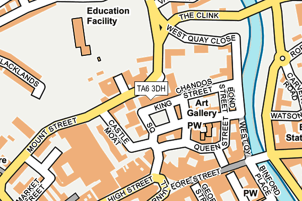
TA6 3DH is located in the Bridgwater South electoral ward, within the unitary authority of Somerset and the English Parliamentary constituency of Bridgwater and West Somerset. The Sub Integrated Care Board (ICB) Location is NHS Somerset ICB - 11X and the police force is Avon and Somerset. This postcode has been in use since January 1980.


GetTheData
Source: OS OpenMap – Local (Ordnance Survey)
Source: OS VectorMap District (Ordnance Survey)
Licence: Open Government Licence (requires attribution)
| Easting | 329826 |
| Northing | 137216 |
| Latitude | 51.129904 |
| Longitude | -3.004226 |
GetTheData
Source: Open Postcode Geo
Licence: Open Government Licence
| Country | England |
| Postcode District | TA6 |
| ➜ TA6 open data dashboard ➜ See where TA6 is on a map ➜ Where is Bridgwater? | |
GetTheData
Source: Land Registry Price Paid Data
Licence: Open Government Licence
Elevation or altitude of TA6 3DH as distance above sea level:
| Metres | Feet | |
|---|---|---|
| Elevation | 10m | 33ft |
Elevation is measured from the approximate centre of the postcode, to the nearest point on an OS contour line from OS Terrain 50, which has contour spacing of ten vertical metres.
➜ How high above sea level am I? Find the elevation of your current position using your device's GPS.
GetTheData
Source: Open Postcode Elevation
Licence: Open Government Licence
| Ward | Bridgwater South |
| Constituency | Bridgwater And West Somerset |
GetTheData
Source: ONS Postcode Database
Licence: Open Government Licence
| January 2024 | Anti-social behaviour | On or near George Street | 243m |
| January 2024 | Drugs | On or near George Street | 243m |
| January 2024 | Public order | On or near George Street | 243m |
| ➜ Get more crime data in our Crime section | |||
GetTheData
Source: data.police.uk
Licence: Open Government Licence
| Magistrates Court (Mount Street) | Bridgwater | 65m |
| Castle Moat | Bridgwater | 112m |
| Angel Place (Northgate) | Bridgwater | 169m |
| High Street 2 (High Street) | Bridgwater | 182m |
| High Street 1 (High Street) | Bridgwater | 194m |
| Bridgwater Station | 1km |
GetTheData
Source: NaPTAN
Licence: Open Government Licence
GetTheData
Source: ONS Postcode Database
Licence: Open Government Licence


➜ Get more ratings from the Food Standards Agency
GetTheData
Source: Food Standards Agency
Licence: FSA terms & conditions
| Last Collection | |||
|---|---|---|---|
| Location | Mon-Fri | Sat | Distance |
| Blacklands | 17:30 | 12:00 | 155m |
| High Street | 17:30 | 12:15 | 191m |
| Angel Place | 17:30 | 12:15 | 193m |
GetTheData
Source: Dracos
Licence: Creative Commons Attribution-ShareAlike
| Facility | Distance |
|---|---|
| Northgate Primary School Northgate, Bridgwater Grass Pitches, Artificial Grass Pitch | 160m |
| Sedgemoor Splash Leisure Centre (Closed) Mount Street, Bridgwater Swimming Pool, Health and Fitness Gym | 193m |
| Puregym (Bridgwater) Bridgwater Health and Fitness Gym | 352m |
GetTheData
Source: Active Places
Licence: Open Government Licence
| School | Phase of Education | Distance |
|---|---|---|
| Northgate Primary School Northgate, Bridgwater, TA6 3EU | Primary | 160m |
| Westover Green Community School and Autism Centre Westover Green, Bridgwater, TA6 7HB | Primary | 720m |
| The Bridge School Sedgemoor The Cossington Centre, Main Road, Cossington, Bridgwater, TA6 3RG | Not applicable | 762m |
GetTheData
Source: Edubase
Licence: Open Government Licence
The below table lists the International Territorial Level (ITL) codes (formerly Nomenclature of Territorial Units for Statistics (NUTS) codes) and Local Administrative Units (LAU) codes for TA6 3DH:
| ITL 1 Code | Name |
|---|---|
| TLK | South West (England) |
| ITL 2 Code | Name |
| TLK2 | Dorset and Somerset |
| ITL 3 Code | Name |
| TLK23 | Somerset CC |
| LAU 1 Code | Name |
| E07000188 | Sedgemoor |
GetTheData
Source: ONS Postcode Directory
Licence: Open Government Licence
The below table lists the Census Output Area (OA), Lower Layer Super Output Area (LSOA), and Middle Layer Super Output Area (MSOA) for TA6 3DH:
| Code | Name | |
|---|---|---|
| OA | E00148264 | |
| LSOA | E01029112 | Sedgemoor 009E |
| MSOA | E02006069 | Sedgemoor 009 |
GetTheData
Source: ONS Postcode Directory
Licence: Open Government Licence
| TA6 3DJ | King Square | 18m |
| TA6 3DG | King Square | 68m |
| TA6 3EU | Chalice Mews | 81m |
| TA6 3FE | Kings Place | 101m |
| TA6 3EW | Angel Crescent | 111m |
| TA6 3BS | York Buildings | 116m |
| TA6 3DL | Chandos Street | 117m |
| TA6 3DB | Castle Street | 127m |
| TA6 3EN | Clare Street | 132m |
| TA6 3DA | Queen Street | 132m |
GetTheData
Source: Open Postcode Geo; Land Registry Price Paid Data
Licence: Open Government Licence