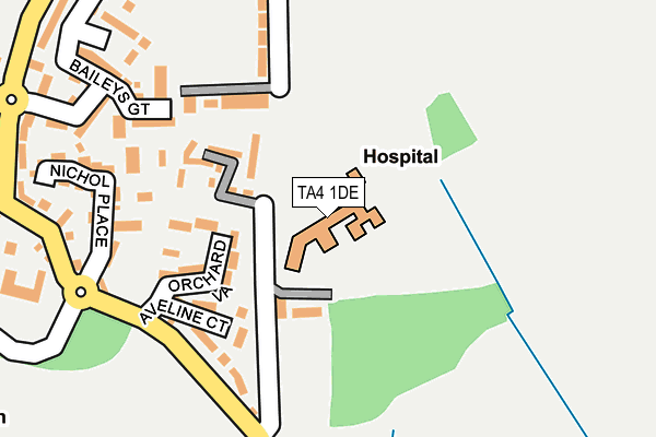
TA4 1DE is located in the Lydeard electoral ward, within the unitary authority of Somerset and the English Parliamentary constituency of Taunton Deane. The Sub Integrated Care Board (ICB) Location is NHS Somerset ICB - 11X and the police force is Avon and Somerset. This postcode has been in use since January 1980.


GetTheData
Source: OS OpenMap – Local (Ordnance Survey)
Source: OS VectorMap District (Ordnance Survey)
Licence: Open Government Licence (requires attribution)
| Easting | 317235 |
| Northing | 127220 |
| Latitude | 51.038354 |
| Longitude | -3.181831 |
GetTheData
Source: Open Postcode Geo
Licence: Open Government Licence
| Country | England |
| Postcode District | TA4 |
| ➜ TA4 open data dashboard ➜ See where TA4 is on a map ➜ Where is Cotford St Luke? | |
GetTheData
Source: Land Registry Price Paid Data
Licence: Open Government Licence
Elevation or altitude of TA4 1DE as distance above sea level:
| Metres | Feet | |
|---|---|---|
| Elevation | 40m | 131ft |
Elevation is measured from the approximate centre of the postcode, to the nearest point on an OS contour line from OS Terrain 50, which has contour spacing of ten vertical metres.
➜ How high above sea level am I? Find the elevation of your current position using your device's GPS.
GetTheData
Source: Open Postcode Elevation
Licence: Open Government Licence
| Ward | Lydeard |
| Constituency | Taunton Deane |
GetTheData
Source: ONS Postcode Database
Licence: Open Government Licence
| June 2022 | Anti-social behaviour | On or near Milsom Place | 101m |
| June 2022 | Anti-social behaviour | On or near Milsom Place | 101m |
| June 2022 | Anti-social behaviour | On or near Milsom Place | 101m |
| ➜ Get more crime data in our Crime section | |||
GetTheData
Source: data.police.uk
Licence: Open Government Licence
| Aveline Court (Dene Road) | Heathfield | 201m |
| Aveline Court (Dene Road) | Heathfield | 209m |
| Baileys Gate (Dene Road) | Heathfield | 317m |
| Baileys Gate (Dene Road) | Heathfield | 326m |
| North Villas (Dene Road) | Heathfield | 351m |
| Bishop's Lydeard | 2km |
GetTheData
Source: NaPTAN
Licence: Open Government Licence
GetTheData
Source: ONS Postcode Database
Licence: Open Government Licence


➜ Get more ratings from the Food Standards Agency
GetTheData
Source: Food Standards Agency
Licence: FSA terms & conditions
| Last Collection | |||
|---|---|---|---|
| Location | Mon-Fri | Sat | Distance |
| Dene Road | 16:30 | 09:15 | 175m |
| Cotford St Luke | 16:45 | 10:00 | 410m |
| Tithill | 10:00 | 10:00 | 860m |
GetTheData
Source: Dracos
Licence: Creative Commons Attribution-ShareAlike
| Facility | Distance |
|---|---|
| Cotford St Luke Playing Field Graham Way, Cotford St. Luke, Taunton Grass Pitches, Outdoor Tennis Courts | 361m |
| Norton Manor Camp Track Norton Manor Camp, Norton Fitzwarren, Taunton Grass Pitches, Health and Fitness Gym, Swimming Pool, Artificial Grass Pitch, Squash Courts, Sports Hall | 1.9km |
| Norton Fitzwarren Playing Field Ellis Grove, Norton Fitzwarren, Taunton Grass Pitches | 2.2km |
GetTheData
Source: Active Places
Licence: Open Government Licence
| School | Phase of Education | Distance |
|---|---|---|
| Cotford St Luke Primary School Bethell Mead, Cotford St Luke, Taunton, TA4 1HZ | Primary | 443m |
| Bishops Lydeard Church School Mount Street, Bishops Lydeard, Taunton, TA4 3AN | Primary | 2.4km |
| Oake, Bradford and Nynehead VC Primary Oake, Taunton, TA4 1AZ | Primary | 2.5km |
GetTheData
Source: Edubase
Licence: Open Government Licence
The below table lists the International Territorial Level (ITL) codes (formerly Nomenclature of Territorial Units for Statistics (NUTS) codes) and Local Administrative Units (LAU) codes for TA4 1DE:
| ITL 1 Code | Name |
|---|---|
| TLK | South West (England) |
| ITL 2 Code | Name |
| TLK2 | Dorset and Somerset |
| ITL 3 Code | Name |
| TLK23 | Somerset CC |
| LAU 1 Code | Name |
| E07000246 | Somerset West and Taunton |
GetTheData
Source: ONS Postcode Directory
Licence: Open Government Licence
The below table lists the Census Output Area (OA), Lower Layer Super Output Area (LSOA), and Middle Layer Super Output Area (MSOA) for TA4 1DE:
| Code | Name | |
|---|---|---|
| OA | E00149050 | |
| LSOA | E01029260 | Taunton Deane 001C |
| MSOA | E02006099 | Taunton Deane 001 |
GetTheData
Source: ONS Postcode Directory
Licence: Open Government Licence
| TA4 1DD | South Villas | 89m |
| TA4 1DF | West Villas | 140m |
| TA4 1JB | Aveline Court | 158m |
| TA4 1JD | Nichol Place | 215m |
| TA4 1DQ | North Villas | 250m |
| TA4 1JE | Baileys Gate | 258m |
| TA4 1GG | Graham Way | 290m |
| TA4 1DA | Dene Road | 292m |
| TA4 1LX | Park View | 318m |
| TA4 1GY | Graham Way | 328m |
GetTheData
Source: Open Postcode Geo; Land Registry Price Paid Data
Licence: Open Government Licence