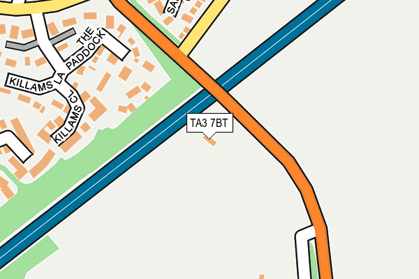
TA3 7BT is in Shoreditch, Taunton. TA3 7BT is located in the Blackdown & Neroche electoral ward, within the unitary authority of Somerset and the English Parliamentary constituency of Taunton Deane. The Sub Integrated Care Board (ICB) Location is NHS Somerset ICB - 11X and the police force is Avon and Somerset. This postcode has been in use since June 1998.


GetTheData
Source: OS OpenMap – Local (Ordnance Survey)
Source: OS VectorMap District (Ordnance Survey)
Licence: Open Government Licence (requires attribution)
| Easting | 324026 |
| Northing | 122544 |
| Latitude | 50.997254 |
| Longitude | -3.084011 |
GetTheData
Source: Open Postcode Geo
Licence: Open Government Licence
| Locality | Shoreditch |
| Town/City | Taunton |
| Country | England |
| Postcode District | TA3 |
| ➜ TA3 open data dashboard ➜ See where TA3 is on a map | |
GetTheData
Source: Land Registry Price Paid Data
Licence: Open Government Licence
Elevation or altitude of TA3 7BT as distance above sea level:
| Metres | Feet | |
|---|---|---|
| Elevation | 30m | 98ft |
Elevation is measured from the approximate centre of the postcode, to the nearest point on an OS contour line from OS Terrain 50, which has contour spacing of ten vertical metres.
➜ How high above sea level am I? Find the elevation of your current position using your device's GPS.
GetTheData
Source: Open Postcode Elevation
Licence: Open Government Licence
| Ward | Blackdown & Neroche |
| Constituency | Taunton Deane |
GetTheData
Source: ONS Postcode Database
Licence: Open Government Licence
| December 2023 | Violence and sexual offences | On or near Celandine Mead | 297m |
| June 2023 | Other theft | On or near Celandine Mead | 297m |
| April 2023 | Drugs | On or near Celandine Mead | 297m |
| ➜ Get more crime data in our Crime section | |||
GetTheData
Source: data.police.uk
Licence: Open Government Licence
| Chestnut Drive (Shoreditch Road) | Taunton | 106m |
| Chestnut Drive (Shoreditch Road) | Taunton | 113m |
| Shoreditch Racecourse (Shoreditch Road) | Shoreditch | 311m |
| Killams Drive (Shoreditch Road) | Taunton | 312m |
| Killams Drive (Shoreditch Road) | Taunton | 317m |
| Taunton Station | 3.2km |
GetTheData
Source: NaPTAN
Licence: Open Government Licence
GetTheData
Source: ONS Postcode Database
Licence: Open Government Licence


➜ Get more ratings from the Food Standards Agency
GetTheData
Source: Food Standards Agency
Licence: FSA terms & conditions
| Last Collection | |||
|---|---|---|---|
| Location | Mon-Fri | Sat | Distance |
| Killiams Avenue | 17:00 | 12:00 | 348m |
| Shoreditch | 10:00 | 08:30 | 373m |
| Shoreditch Road | 17:00 | 12:00 | 593m |
GetTheData
Source: Dracos
Licence: Creative Commons Attribution-ShareAlike
| Facility | Distance |
|---|---|
| Wyvern Club Mountfields Road, Taunton Squash Courts, Grass Pitches, Outdoor Tennis Courts | 954m |
| Bishop Fox's School Bishop Fox Drive, Taunton Sports Hall, Health and Fitness Gym, Grass Pitches, Artificial Grass Pitch | 1.2km |
| Richard Huish College South Road, Taunton Sports Hall, Grass Pitches, Health and Fitness Gym | 1.3km |
GetTheData
Source: Active Places
Licence: Open Government Licence
| School | Phase of Education | Distance |
|---|---|---|
| Bishop Fox's School Bishop Fox Drive, Taunton, TA1 3HQ | Secondary | 1.2km |
| Richard Huish College South Road, Taunton, TA1 3DZ | 16 plus | 1.3km |
| Holway Park Community Primary School Shakespeare Avenue, Taunton, TA1 2JA | Primary | 1.5km |
GetTheData
Source: Edubase
Licence: Open Government Licence
The below table lists the International Territorial Level (ITL) codes (formerly Nomenclature of Territorial Units for Statistics (NUTS) codes) and Local Administrative Units (LAU) codes for TA3 7BT:
| ITL 1 Code | Name |
|---|---|
| TLK | South West (England) |
| ITL 2 Code | Name |
| TLK2 | Dorset and Somerset |
| ITL 3 Code | Name |
| TLK23 | Somerset CC |
| LAU 1 Code | Name |
| E07000246 | Somerset West and Taunton |
GetTheData
Source: ONS Postcode Directory
Licence: Open Government Licence
The below table lists the Census Output Area (OA), Lower Layer Super Output Area (LSOA), and Middle Layer Super Output Area (MSOA) for TA3 7BT:
| Code | Name | |
|---|---|---|
| OA | E00149120 | |
| LSOA | E01029270 | Taunton Deane 014B |
| MSOA | E02006112 | Taunton Deane 014 |
GetTheData
Source: ONS Postcode Directory
Licence: Open Government Licence
| TA1 3XW | Saffron Close | 204m |
| TA1 3LD | Killams Close | 208m |
| TA1 3YA | Killams Lane | 212m |
| TA1 3XN | Bilberry Grove | 287m |
| TA1 3XF | Celandine Mead | 310m |
| TA1 3YQ | Killams Green | 355m |
| TA1 3XL | Orchid Close | 387m |
| TA1 3YB | Killams Crescent | 392m |
| TA3 7BL | 409m | |
| TA1 3DE | Fullands Avenue | 414m |
GetTheData
Source: Open Postcode Geo; Land Registry Price Paid Data
Licence: Open Government Licence