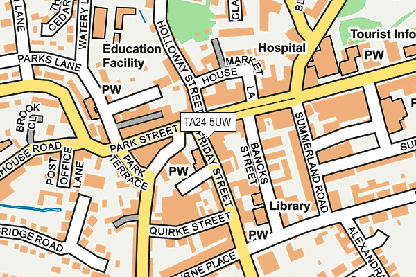
TA24 5UW lies on Floyds Corner in Minehead. TA24 5UW is located in the Minehead electoral ward, within the unitary authority of Somerset and the English Parliamentary constituency of Bridgwater and West Somerset. The Sub Integrated Care Board (ICB) Location is NHS Somerset ICB - 11X and the police force is Avon and Somerset. This postcode has been in use since March 1988.


GetTheData
Source: OS OpenMap – Local (Ordnance Survey)
Source: OS VectorMap District (Ordnance Survey)
Licence: Open Government Licence (requires attribution)
| Easting | 296796 |
| Northing | 146173 |
| Latitude | 51.205413 |
| Longitude | -3.478685 |
GetTheData
Source: Open Postcode Geo
Licence: Open Government Licence
| Street | Floyds Corner |
| Town/City | Minehead |
| Country | England |
| Postcode District | TA24 |
| ➜ TA24 open data dashboard ➜ See where TA24 is on a map ➜ Where is Minehead? | |
GetTheData
Source: Land Registry Price Paid Data
Licence: Open Government Licence
Elevation or altitude of TA24 5UW as distance above sea level:
| Metres | Feet | |
|---|---|---|
| Elevation | 20m | 66ft |
Elevation is measured from the approximate centre of the postcode, to the nearest point on an OS contour line from OS Terrain 50, which has contour spacing of ten vertical metres.
➜ How high above sea level am I? Find the elevation of your current position using your device's GPS.
GetTheData
Source: Open Postcode Elevation
Licence: Open Government Licence
| Ward | Minehead |
| Constituency | Bridgwater And West Somerset |
GetTheData
Source: ONS Postcode Database
Licence: Open Government Licence
| January 2024 | Violence and sexual offences | On or near Parking Area | 363m |
| January 2024 | Public order | On or near Parking Area | 363m |
| January 2024 | Public order | On or near Parking Area | 363m |
| ➜ Get more crime data in our Crime section | |||
GetTheData
Source: data.police.uk
Licence: Open Government Licence
| The Parade | Minehead | 43m |
| Bancks Street | Minehead | 68m |
| Blenheim Mews | Periton | 220m |
| The Avenue | Minehead | 229m |
| Roman Catholic Church (Townsend Road) | Minehead | 244m |
| Minehead (West Somerset Railway) | Minehead | 696m |
GetTheData
Source: NaPTAN
Licence: Open Government Licence
| Percentage of properties with Next Generation Access | 100.0% |
| Percentage of properties with Superfast Broadband | 100.0% |
| Percentage of properties with Ultrafast Broadband | 0.0% |
| Percentage of properties with Full Fibre Broadband | 0.0% |
Superfast Broadband is between 30Mbps and 300Mbps
Ultrafast Broadband is > 300Mbps
| Percentage of properties unable to receive 2Mbps | 0.0% |
| Percentage of properties unable to receive 5Mbps | 0.0% |
| Percentage of properties unable to receive 10Mbps | 0.0% |
| Percentage of properties unable to receive 30Mbps | 0.0% |
GetTheData
Source: Ofcom
Licence: Ofcom Terms of Use (requires attribution)
GetTheData
Source: ONS Postcode Database
Licence: Open Government Licence


➜ Get more ratings from the Food Standards Agency
GetTheData
Source: Food Standards Agency
Licence: FSA terms & conditions
| Last Collection | |||
|---|---|---|---|
| Location | Mon-Fri | Sat | Distance |
| The Avenue Post Office | 17:00 | 12:30 | 272m |
| Staunton Road | 16:30 | 12:15 | 1,088m |
| Somerwest World | 16:30 | 12:00 | 1,248m |
GetTheData
Source: Dracos
Licence: Creative Commons Attribution-ShareAlike
| Facility | Distance |
|---|---|
| Minehead Baptist Church The Parks, Minehead Sports Hall | 175m |
| Minehead First School Townsend Road, Minehead Swimming Pool, Sports Hall | 332m |
| Minehead Lawn Tennis Club Townsend Road, Minehead Outdoor Tennis Courts | 364m |
GetTheData
Source: Active Places
Licence: Open Government Licence
| School | Phase of Education | Distance |
|---|---|---|
| St Michael's Church of England First School Watery Lane, Minehead, TA24 5NY | Primary | 236m |
| Aurora Foxes Selbourne Place, Minehead, TA24 5TY | Not applicable | 259m |
| Minehead First School Townsend Road, Minehead, TA24 5RG | Primary | 332m |
GetTheData
Source: Edubase
Licence: Open Government Licence
The below table lists the International Territorial Level (ITL) codes (formerly Nomenclature of Territorial Units for Statistics (NUTS) codes) and Local Administrative Units (LAU) codes for TA24 5UW:
| ITL 1 Code | Name |
|---|---|
| TLK | South West (England) |
| ITL 2 Code | Name |
| TLK2 | Dorset and Somerset |
| ITL 3 Code | Name |
| TLK23 | Somerset CC |
| LAU 1 Code | Name |
| E07000246 | Somerset West and Taunton |
GetTheData
Source: ONS Postcode Directory
Licence: Open Government Licence
The below table lists the Census Output Area (OA), Lower Layer Super Output Area (LSOA), and Middle Layer Super Output Area (MSOA) for TA24 5UW:
| Code | Name | |
|---|---|---|
| OA | E00149442 | |
| LSOA | E01029330 | West Somerset 001D |
| MSOA | E02006113 | West Somerset 001 |
GetTheData
Source: ONS Postcode Directory
Licence: Open Government Licence
| TA24 5NP | Holloway Street | 68m |
| TA24 5UB | Friday Street | 69m |
| TA24 5UA | Friday Street | 75m |
| TA24 5NT | Tythings Court | 77m |
| TA24 5NL | The Parade | 88m |
| TA24 5NQ | Park Street | 92m |
| TA24 5UR | St Andrews Lane | 100m |
| TA24 5TR | Bampton Street | 105m |
| TA24 5DJ | Bancks Street | 110m |
| TA24 5NS | Parkhouse Cottages | 115m |
GetTheData
Source: Open Postcode Geo; Land Registry Price Paid Data
Licence: Open Government Licence