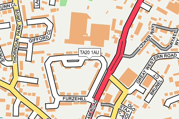
TA20 1AU is located in the Chard North electoral ward, within the unitary authority of Somerset and the English Parliamentary constituency of Yeovil. The Sub Integrated Care Board (ICB) Location is NHS Somerset ICB - 11X and the police force is Avon and Somerset. This postcode has been in use since January 1980.


GetTheData
Source: OS OpenMap – Local (Ordnance Survey)
Source: OS VectorMap District (Ordnance Survey)
Licence: Open Government Licence (requires attribution)
| Easting | 332751 |
| Northing | 109288 |
| Latitude | 50.879156 |
| Longitude | -2.957248 |
GetTheData
Source: Open Postcode Geo
Licence: Open Government Licence
| Country | England |
| Postcode District | TA20 |
| ➜ TA20 open data dashboard ➜ See where TA20 is on a map ➜ Where is Chard? | |
GetTheData
Source: Land Registry Price Paid Data
Licence: Open Government Licence
Elevation or altitude of TA20 1AU as distance above sea level:
| Metres | Feet | |
|---|---|---|
| Elevation | 90m | 295ft |
Elevation is measured from the approximate centre of the postcode, to the nearest point on an OS contour line from OS Terrain 50, which has contour spacing of ten vertical metres.
➜ How high above sea level am I? Find the elevation of your current position using your device's GPS.
GetTheData
Source: Open Postcode Elevation
Licence: Open Government Licence
| Ward | Chard North |
| Constituency | Yeovil |
GetTheData
Source: ONS Postcode Database
Licence: Open Government Licence
| December 2023 | Violence and sexual offences | On or near Britannia Way | 413m |
| December 2023 | Violence and sexual offences | On or near Britannia Way | 413m |
| November 2023 | Public order | On or near Phelps Close | 367m |
| ➜ Get more crime data in our Crime section | |||
GetTheData
Source: data.police.uk
Licence: Open Government Licence
| The Old Station (Great Western Road) | Chard | 176m |
| The Old Station (Great Western Road) | Chard | 187m |
| Oscar Meyer (Furnham Road) | Chard | 189m |
| Oscar Meyer | Chard | 207m |
| Thorndun Park Drive (Thorndurn Park Drive) | Chard | 288m |
GetTheData
Source: NaPTAN
Licence: Open Government Licence
| Percentage of properties with Next Generation Access | 100.0% |
| Percentage of properties with Superfast Broadband | 100.0% |
| Percentage of properties with Ultrafast Broadband | 0.0% |
| Percentage of properties with Full Fibre Broadband | 0.0% |
Superfast Broadband is between 30Mbps and 300Mbps
Ultrafast Broadband is > 300Mbps
| Percentage of properties unable to receive 2Mbps | 0.0% |
| Percentage of properties unable to receive 5Mbps | 0.0% |
| Percentage of properties unable to receive 10Mbps | 0.0% |
| Percentage of properties unable to receive 30Mbps | 0.0% |
GetTheData
Source: Ofcom
Licence: Ofcom Terms of Use (requires attribution)
GetTheData
Source: ONS Postcode Database
Licence: Open Government Licence


➜ Get more ratings from the Food Standards Agency
GetTheData
Source: Food Standards Agency
Licence: FSA terms & conditions
| Last Collection | |||
|---|---|---|---|
| Location | Mon-Fri | Sat | Distance |
| Glynswood | 16:30 | 12:00 | 277m |
| Thorndun Park | 16:30 | 12:00 | 470m |
| Elizabeth Way | 16:15 | 12:00 | 597m |
GetTheData
Source: Dracos
Licence: Creative Commons Attribution-ShareAlike
| Facility | Distance |
|---|---|
| 1610 Chard Jarman Way, Chard Health and Fitness Gym | 662m |
| Cresta Leisure Centre (Closed) Zembard Lane, Chard Swimming Pool, Health and Fitness Gym, Squash Courts, Studio | 668m |
| Chard Rfc Essex Close, Essex Close, Chard Grass Pitches | 675m |
GetTheData
Source: Active Places
Licence: Open Government Licence
| School | Phase of Education | Distance |
|---|---|---|
| The Redstart Primary School Redstart Road, The Redstart Primary School, Chard, TA20 1SD | Primary | 631m |
| Avishayes Community Primary School Fairway Rise, Chard, TA20 1NS | Primary | 676m |
| Holyrood Academy Zembard Lane, Chard, TA20 1JL | Secondary | 677m |
GetTheData
Source: Edubase
Licence: Open Government Licence
The below table lists the International Territorial Level (ITL) codes (formerly Nomenclature of Territorial Units for Statistics (NUTS) codes) and Local Administrative Units (LAU) codes for TA20 1AU:
| ITL 1 Code | Name |
|---|---|
| TLK | South West (England) |
| ITL 2 Code | Name |
| TLK2 | Dorset and Somerset |
| ITL 3 Code | Name |
| TLK23 | Somerset CC |
| LAU 1 Code | Name |
| E07000189 | South Somerset |
GetTheData
Source: ONS Postcode Directory
Licence: Open Government Licence
The below table lists the Census Output Area (OA), Lower Layer Super Output Area (LSOA), and Middle Layer Super Output Area (MSOA) for TA20 1AU:
| Code | Name | |
|---|---|---|
| OA | E00148604 | |
| LSOA | E01029171 | South Somerset 023B |
| MSOA | E02006097 | South Somerset 023 |
GetTheData
Source: ONS Postcode Directory
Licence: Open Government Licence
| TA20 1AT | Furzehill | 35m |
| TA20 1AP | Furnham Road | 114m |
| TA20 1AR | Furzehill | 116m |
| TA20 1HG | Cary Mews | 161m |
| TA20 1AS | Furzehill | 166m |
| TA20 1BP | Gifford Close | 179m |
| TA20 1DN | Webster Way | 214m |
| TA20 1EH | Old Station Court | 218m |
| TA20 1AJ | Glynswood | 219m |
| TA20 1AN | Furnham Road | 229m |
GetTheData
Source: Open Postcode Geo; Land Registry Price Paid Data
Licence: Open Government Licence