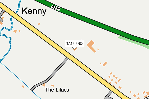
TA19 9NQ is located in the Ilminster electoral ward, within the unitary authority of Somerset and the English Parliamentary constituency of Yeovil. The Sub Integrated Care Board (ICB) Location is NHS Somerset ICB - 11X and the police force is Avon and Somerset. This postcode has been in use since January 1980.


GetTheData
Source: OS OpenMap – Local (Ordnance Survey)
Source: OS VectorMap District (Ordnance Survey)
Licence: Open Government Licence (requires attribution)
| Easting | 331769 |
| Northing | 117682 |
| Latitude | 50.954511 |
| Longitude | -2.972777 |
GetTheData
Source: Open Postcode Geo
Licence: Open Government Licence
| Country | England |
| Postcode District | TA19 |
| ➜ TA19 open data dashboard ➜ See where TA19 is on a map | |
GetTheData
Source: Land Registry Price Paid Data
Licence: Open Government Licence
Elevation or altitude of TA19 9NQ as distance above sea level:
| Metres | Feet | |
|---|---|---|
| Elevation | 50m | 164ft |
Elevation is measured from the approximate centre of the postcode, to the nearest point on an OS contour line from OS Terrain 50, which has contour spacing of ten vertical metres.
➜ How high above sea level am I? Find the elevation of your current position using your device's GPS.
GetTheData
Source: Open Postcode Elevation
Licence: Open Government Licence
| Ward | Ilminster |
| Constituency | Yeovil |
GetTheData
Source: ONS Postcode Database
Licence: Open Government Licence
| February 2022 | Other crime | On or near Harvey Way | 204m |
| February 2022 | Other theft | On or near Harvey Way | 204m |
| February 2022 | Other theft | On or near Harvey Way | 204m |
| ➜ Get more crime data in our Crime section | |||
GetTheData
Source: data.police.uk
Licence: Open Government Licence
| Stewley Lodge | Kenny | 453m |
| Stewley Lodge | Kenny | 453m |
| Ashill Inn | Ashill | 522m |
| Ashill Farm (Crow Lane) | Ashill | 529m |
GetTheData
Source: NaPTAN
Licence: Open Government Licence
GetTheData
Source: ONS Postcode Database
Licence: Open Government Licence


➜ Get more ratings from the Food Standards Agency
GetTheData
Source: Food Standards Agency
Licence: FSA terms & conditions
| Last Collection | |||
|---|---|---|---|
| Location | Mon-Fri | Sat | Distance |
| Cad Green | 10:00 | 09:30 | 3,253m |
| Hare | 12:30 | 11:00 | 3,554m |
| Dommett | 12:30 | 11:15 | 4,568m |
GetTheData
Source: Dracos
Licence: Creative Commons Attribution-ShareAlike
| Facility | Distance |
|---|---|
| Broadway & Horton Cricket Club Pound Road, Broadway, Ilminster Grass Pitches | 2.1km |
| Broadway Village Hall Church Lane, Broadway, Ilminster Sports Hall | 2.7km |
| Ilton Recreational Field Copse Lane, Ilton, Ilminster Grass Pitches | 3.2km |
GetTheData
Source: Active Places
Licence: Open Government Licence
| School | Phase of Education | Distance |
|---|---|---|
| Ashill Community Primary School School Road, Ashill, Ilminster, TA19 9ND | Primary | 553m |
| Neroche Primary School Broadway, Ilminster, TA19 9RG | Primary | 2.3km |
| Hatch Beauchamp Church of England Primary School Station Road, Somerset, Taunton, TA3 6SQ | Primary | 3.1km |
GetTheData
Source: Edubase
Licence: Open Government Licence
The below table lists the International Territorial Level (ITL) codes (formerly Nomenclature of Territorial Units for Statistics (NUTS) codes) and Local Administrative Units (LAU) codes for TA19 9NQ:
| ITL 1 Code | Name |
|---|---|
| TLK | South West (England) |
| ITL 2 Code | Name |
| TLK2 | Dorset and Somerset |
| ITL 3 Code | Name |
| TLK23 | Somerset CC |
| LAU 1 Code | Name |
| E07000189 | South Somerset |
GetTheData
Source: ONS Postcode Directory
Licence: Open Government Licence
The below table lists the Census Output Area (OA), Lower Layer Super Output Area (LSOA), and Middle Layer Super Output Area (MSOA) for TA19 9NQ:
| Code | Name | |
|---|---|---|
| OA | E00148787 | |
| LSOA | E01029209 | South Somerset 019E |
| MSOA | E02006093 | South Somerset 019 |
GetTheData
Source: ONS Postcode Directory
Licence: Open Government Licence
| TA19 9QD | Harvey Way | 192m |
| TA19 9NE | 328m | |
| TA19 9NH | Kenny | 355m |
| TA19 9NY | Wyatts Way | 369m |
| TA19 9ND | 511m | |
| TA19 9LY | 586m | |
| TA19 9LZ | Ashton Close | 592m |
| TA19 9NA | 598m | |
| TA19 9NP | Wood Road | 612m |
| TA19 9PA | Windmill Hill Lane | 622m |
GetTheData
Source: Open Postcode Geo; Land Registry Price Paid Data
Licence: Open Government Licence