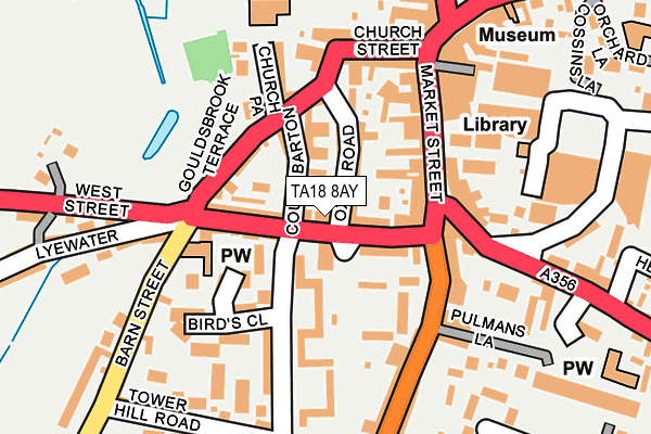
TA18 8AY is located in the Crewkerne electoral ward, within the unitary authority of Somerset and the English Parliamentary constituency of Yeovil. The Sub Integrated Care Board (ICB) Location is NHS Somerset ICB - 11X and the police force is Avon and Somerset. This postcode has been in use since January 1980.


GetTheData
Source: OS OpenMap – Local (Ordnance Survey)
Source: OS VectorMap District (Ordnance Survey)
Licence: Open Government Licence (requires attribution)
| Easting | 344010 |
| Northing | 109609 |
| Latitude | 50.883245 |
| Longitude | -2.797280 |
GetTheData
Source: Open Postcode Geo
Licence: Open Government Licence
| Country | England |
| Postcode District | TA18 |
| ➜ TA18 open data dashboard ➜ See where TA18 is on a map ➜ Where is Crewkerne? | |
GetTheData
Source: Land Registry Price Paid Data
Licence: Open Government Licence
Elevation or altitude of TA18 8AY as distance above sea level:
| Metres | Feet | |
|---|---|---|
| Elevation | 80m | 262ft |
Elevation is measured from the approximate centre of the postcode, to the nearest point on an OS contour line from OS Terrain 50, which has contour spacing of ten vertical metres.
➜ How high above sea level am I? Find the elevation of your current position using your device's GPS.
GetTheData
Source: Open Postcode Elevation
Licence: Open Government Licence
| Ward | Crewkerne |
| Constituency | Yeovil |
GetTheData
Source: ONS Postcode Database
Licence: Open Government Licence
| January 2024 | Violence and sexual offences | On or near Parking Area | 73m |
| January 2024 | Public order | On or near Parking Area | 237m |
| January 2024 | Violence and sexual offences | On or near Parking Area | 237m |
| ➜ Get more crime data in our Crime section | |||
GetTheData
Source: data.police.uk
Licence: Open Government Licence
| West Street (A30) | Crewkerne | 193m |
| West Street (A30) | Crewkerne | 193m |
| George Hotel (Market Square) | Crewkerne | 211m |
| Kings Arms (Market Square) | Crewkerne | 252m |
| South Street | Crewkerne | 388m |
| Crewkerne Station | 1.7km |
GetTheData
Source: NaPTAN
Licence: Open Government Licence
| Percentage of properties with Next Generation Access | 100.0% |
| Percentage of properties with Superfast Broadband | 100.0% |
| Percentage of properties with Ultrafast Broadband | 0.0% |
| Percentage of properties with Full Fibre Broadband | 0.0% |
Superfast Broadband is between 30Mbps and 300Mbps
Ultrafast Broadband is > 300Mbps
| Percentage of properties unable to receive 2Mbps | 0.0% |
| Percentage of properties unable to receive 5Mbps | 0.0% |
| Percentage of properties unable to receive 10Mbps | 0.0% |
| Percentage of properties unable to receive 30Mbps | 0.0% |
GetTheData
Source: Ofcom
Licence: Ofcom Terms of Use (requires attribution)
GetTheData
Source: ONS Postcode Database
Licence: Open Government Licence


➜ Get more ratings from the Food Standards Agency
GetTheData
Source: Food Standards Agency
Licence: FSA terms & conditions
| Last Collection | |||
|---|---|---|---|
| Location | Mon-Fri | Sat | Distance |
| Faulkland Square | 17:00 | 11:00 | 149m |
| East Street Post Office | 17:15 | 12:00 | 275m |
| South Street | 17:00 | 11:00 | 532m |
GetTheData
Source: Dracos
Licence: Creative Commons Attribution-ShareAlike
| Facility | Distance |
|---|---|
| Crewkerne Health Club (Closed) Market Square, Crewkerne Health and Fitness Gym, Studio | 219m |
| Crewkerne Aqua Centre Henhayes, Crewkerne Swimming Pool, Health and Fitness Gym, Studio | 289m |
| Henhayes Recreation Ground Henhayes Lane, Crewkerne Grass Pitches | 322m |
GetTheData
Source: Active Places
Licence: Open Government Licence
| School | Phase of Education | Distance |
|---|---|---|
| Ashlands Church of England Primary School North Street, Crewkerne, TA18 7AL | Primary | 408m |
| St Bartholomew's Church of England Primary School Kithill, Crewkerne, TA18 8AS | Primary | 758m |
| Maiden Beech Academy Lyme Road, Crewkerne, TA18 8HG | Primary | 931m |
GetTheData
Source: Edubase
Licence: Open Government Licence
The below table lists the International Territorial Level (ITL) codes (formerly Nomenclature of Territorial Units for Statistics (NUTS) codes) and Local Administrative Units (LAU) codes for TA18 8AY:
| ITL 1 Code | Name |
|---|---|
| TLK | South West (England) |
| ITL 2 Code | Name |
| TLK2 | Dorset and Somerset |
| ITL 3 Code | Name |
| TLK23 | Somerset CC |
| LAU 1 Code | Name |
| E07000189 | South Somerset |
GetTheData
Source: ONS Postcode Directory
Licence: Open Government Licence
The below table lists the Census Output Area (OA), Lower Layer Super Output Area (LSOA), and Middle Layer Super Output Area (MSOA) for TA18 8AY:
| Code | Name | |
|---|---|---|
| OA | E00148674 | |
| LSOA | E01029185 | South Somerset 021D |
| MSOA | E02006095 | South Somerset 021 |
GetTheData
Source: ONS Postcode Directory
Licence: Open Government Licence
| TA18 7HN | Oxen Road | 58m |
| TA18 7HP | Court Barton | 63m |
| TA18 8AX | West Street | 67m |
| TA18 7HT | Gouldsbarton | 71m |
| TA18 8AP | Hurle House Yard | 76m |
| TA18 8AZ | West Street | 78m |
| TA18 7JA | Goulds Brook Terrace | 91m |
| TA18 7LA | Market Street | 94m |
| TA18 8EP | West Street | 100m |
| TA18 8ES | Hermitage Street | 114m |
GetTheData
Source: Open Postcode Geo; Land Registry Price Paid Data
Licence: Open Government Licence